Related Research Articles

Satellite temperature measurements are inferences of the temperature of the atmosphere at various altitudes as well as sea and land surface temperatures obtained from radiometric measurements by satellites. These measurements can be used to locate weather fronts, monitor the El Niño-Southern Oscillation, determine the strength of tropical cyclones, study urban heat islands and monitor the global climate. Wildfires, volcanos, and industrial hot spots can also be found via thermal imaging from weather satellites.

A microwave radiometer (MWR) is a radiometer that measures energy emitted at one millimeter-to-metre wavelengths (frequencies of 0.3–300 GHz) known as microwaves. Microwave radiometers are very sensitive receivers designed to measure thermally-emitted electromagnetic radiation. They are usually equipped with multiple receiving channels to derive the characteristic emission spectrum of planetary atmospheres, surfaces or extraterrestrial objects. Microwave radiometers are utilized in a variety of environmental and engineering applications, including remote sensing, weather forecasting, climate monitoring, radio astronomy and radio propagation studies.

Clouds and the Earth's Radiant Energy System (CERES) is on-going NASA climatological experiment from Earth orbit. The CERES are scientific satellite instruments, part of the NASA's Earth Observing System (EOS), designed to measure both solar-reflected and Earth-emitted radiation from the top of the atmosphere (TOA) to the Earth's surface. Cloud properties are determined using simultaneous measurements by other EOS instruments such as the Moderate Resolution Imaging Spectroradiometer (MODIS). Results from the CERES and other NASA missions, such as the Earth Radiation Budget Experiment (ERBE), could enable nearer to real-time tracking of Earth's energy imbalance and better understanding of the role of clouds in global climate change.

The advanced microwave sounding unit (AMSU) is a multi-channel microwave radiometer installed on meteorological satellites. The instrument examines several bands of microwave radiation from the atmosphere to perform atmospheric sounding of temperature and moisture levels.

NOAA-19, known as NOAA-N' before launch, is the last of the American National Oceanic and Atmospheric Administration (NOAA) series of weather satellites. NOAA-19 was launched on 6 February 2009. NOAA-19 is in an afternoon Sun-synchronous orbit and is intended to replace NOAA-18 as the prime afternoon spacecraft.

NOAA-17, also known as NOAA-M before launch, was an operational, polar orbiting, weather satellite series operated by the National Environmental Satellite Service (NESS) of the National Oceanic and Atmospheric Administration (NOAA). NOAA-17 also continued the series of Advanced TIROS-N (ATN) spacecraft begun with the launch of NOAA-8 (NOAA-E) in 1983 but with additional new and improved instrumentation over the NOAA A-L series and a new launch vehicle.

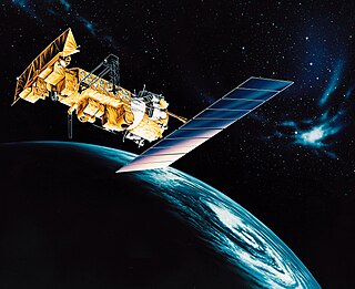
NOAA-16, also known as NOAA-L before launch, was an operational, polar orbiting, weather satellite series operated by the National Environmental Satellite Service (NESS) of the National Oceanic and Atmospheric Administration (NOAA). NOAA-16 continued the series of Advanced TIROS-N (ATN) spacecraft that began with the launch of NOAA-8 (NOAA-E) in 1983; but it had additional new and improved instrumentation over the NOAA A-K series and a new launch vehicle. It was launched on 21 September 2000 and, following an unknown anomaly, it was decommissioned on 9 June 2014. In November of 2015 it broke up in orbit, creating more than 200 pieces of debris.

NOAA-18, also known as NOAA-N before launch, is an operational, polar orbiting, weather satellite series operated by the National Environmental Satellite Service (NESS) of the National Oceanic and Atmospheric Administration (NOAA). NOAA-18 also continued the series of Advanced TIROS-N (ATN) spacecraft begun with the launch of NOAA-8 (NOAA-E) in 1983 but with additional new and improved instrumentation over the NOAA A-M series and a new launch vehicle. NOAA-18 is in an afternoon equator-crossing orbit and replaced NOAA-17 as the prime afternoon spacecraft.
NOAA-15, also known as NOAA-K before launch, is an operational, polar-orbiting of the NASA-provided Television Infrared Observation Satellite (TIROS) series of weather forecasting satellite operated by National Oceanic and Atmospheric Administration (NOAA). NOAA-15 was the latest in the Advanced TIROS-N (ATN) series. It provided support to environmental monitoring by complementing the NOAA/NESS Geostationary Operational Environmental Satellite program (GOES).
The Humidity Sounder for Brazil (HSB) was an instrument launched on NASA's Earth Observing System satellite Aqua launched in May 2002. It was a four-channel passive microwave radiometer, with one channel at 150 GHz and three channels at 183 GHz. It was very similar in design to the AMSU-B instrument, except it lacked the 89 GHz surface sounding channel. It was intended to study profiles of atmospheric water vapor and provide improved input data to the cloud-clearing algorithms in the Unified AIRS Retrieval Suite, but the scan mirror motor failed on February 5, 2003. It worked with the Atmospheric Infrared Sounder and AMSU-A to form the AIRS Sounding Suite.
The Polar-orbiting Operational Environmental Satellite (POES) was a constellation of polar orbiting weather satellites funded by the National Oceanic and Atmospheric Administration (NOAA) and the European Organisation for the Exploitation of Meteorological Satellites (EUMETSAT) with the intent of improving the accuracy and detail of weather analysis and forecasting. The spacecraft were provided by NASA and the European Space Agency (ESA), and NASA's Goddard Space Flight Center oversaw the manufacture, integration and test of the NASA-provided TIROS satellites. The first polar-orbiting weather satellite launched as part of the POES constellation was the Television Infrared Observation Satellite-N (TIROS-N), which was launched on 13 October 1978. The final spacecraft, NOAA-19, was launched on 6 February 2009. The ESA-provided MetOp satellite operated by EUMETSAT utilize POES-heritage instruments for the purpose of data continuity. The Joint Polar Satellite System, which was launched on 18 November 2017, is the successor to the POES Program.
The Special Sensor Microwave Imager / Sounder (SSMIS) is a 24-channel, 21-frequency, linearly polarized passive microwave radiometer system. The instrument is flown on board the United States Air Force Defense Meteorological Satellite Program (DMSP) F-16, F-17, F-18 and F-19 satellites, which were launched in October 2003, November 2006, October 2009, and April 2014, respectively. It is the successor to the Special Sensor Microwave/Imager (SSM/I). The SSMIS on the F19 satellite stopped producing useful data in February 2016.
Ozone Mapping and Profiler Suite (OMPS), is a suite of instruments built by Ball Aerospace that measure the global distribution of ozone and, less frequently, how it is distributed vertically within the stratosphere. The suite flies on the Suomi NPP and NOAA-20 (formerly JPSS-1) satellites along with several other instruments. It had been intended to also fly on the NPOESS, for which the NPP was a preparatory project, but the dissolution of that project was announced in 2010. OMPS launched on October 28, 2011.
The microwave sounding unit (MSU) was the predecessor to the Advanced Microwave Sounding Unit (AMSU).
Collocation is a procedure used in remote sensing to match measurements from two or more different instruments. This is done for two main reasons: for validation purposes when comparing measurements of the same variable, and to relate measurements of two different variables either for performing retrievals or for prediction. In the second case the data is later fed into some type of statistical inverse method such as an artificial neural network, statistical classification algorithm, kernel estimator or a linear least squares. In principle, most collocation problems can be solved by a nearest neighbor search, but in practice there are many other considerations involved and the best method is highly specific to the particular matching of instruments. Here we deal with some of the most important considerations along with specific examples.

The Joint Polar Satellite System (JPSS) is the latest generation of U.S. polar-orbiting, non-geosynchronous, environmental satellites. JPSS will provide the global environmental data used in numerical weather prediction models for forecasts, and scientific data used for climate monitoring. JPSS will aid in fulfilling the mission of the U.S. National Oceanic and Atmospheric Administration (NOAA), an agency of the Department of Commerce. Data and imagery obtained from the JPSS will increase timeliness and accuracy of public warnings and forecasts of climate and weather events, thus reducing the potential loss of human life and property and advancing the national economy. The JPSS is developed by the National Aeronautics and Space Administration (NASA) for the National Oceanic and Atmospheric Administration (NOAA), who is responsible for operation of JPSS. Three to five satellites are planned for the JPSS constellation of satellites. JPSS satellites will be flown, and the scientific data from JPSS will be processed, by the JPSS – Common Ground System (JPSS-CGS).

The Suomi National Polar-orbiting Partnership, previously known as the National Polar-orbiting Operational Environmental Satellite System Preparatory Project (NPP) and NPP-Bridge, is a weather satellite operated by the United States National Oceanic and Atmospheric Administration (NOAA). It was launched in 2011 and continues to operate in June 2022.

The Visible Infrared Imaging Radiometer Suite (VIIRS) is a sensor designed and manufactured by the Raytheon Company on board the polar-orbiting Suomi National Polar-orbiting Partnership, NOAA-20, and NOAA-21 weather satellites. VIIRS is one of five key instruments onboard Suomi NPP, launched on October 28, 2011. VIIRS is a whiskbroom scanner radiometer that collects imagery and radiometric measurements of the land, atmosphere, cryosphere, and oceans in the visible and infrared bands of the electromagnetic spectrum.

NOAA-21, designated JPSS-2 prior to launch, is the second of the United States National Oceanic and Atmospheric Administration (NOAA)'s latest generation of U.S. polar-orbiting, non-geosynchronous, environmental satellites called the Joint Polar Satellite System. NOAA-21 was launched on 10 November 2022 and join NOAA-20 and Suomi NPP in the same orbit. Circling the Earth from pole-to-pole, it will cross the equator about 14 times daily, providing full global coverage twice a day.
NOAA-20, designated JPSS-1 prior to launch, is the first of the United States National Oceanic and Atmospheric Administration's latest generation of U.S. polar-orbiting, non-geosynchronous, environmental satellites called the Joint Polar Satellite System. NOAA-20 was launched on 18 November 2017 and joined the Suomi National Polar-orbiting Partnership satellite in the same orbit. NOAA-20 operates about 50 minutes behind Suomi NPP, allowing important overlap in observational coverage. Circling the Earth from pole-to-pole, it crosses the equator about 14 times daily, providing full global coverage twice a day. This gives meteorologists information on "atmospheric temperature and moisture, clouds, sea-surface temperature, ocean color, sea ice cover, volcanic ash, and fire detection" so as to enhance weather forecasting including hurricane tracking, post-hurricane recovery by detailing storm damage and mapping of power outages.
References
- 1 2 3 4 Kim, E.; Lyu, C.-H. J.; Anderson, K.; Leslie, R. V.; Blackwell, W. J. (2014), "S-NPP ATMS instrument prelaunch and on-orbit performance evaluation", J. Geophys. Res. Atmos., 119 (9): 5653–5670, Bibcode:2014JGRD..119.5653K, doi: 10.1002/2013JD020483
- 1 2 3 Kim, E.; et al. (2020). Pre-launch performance of the Advanced Technology Microwave Sounder (ATMS) on the Joint Polar Satellite System-2 Satellite (JPSS-2). International Geoscience and Remote Sensing Symposium. Waikoloa, HI, USA. pp. 6353–6. doi:10.1109/IGARSS39084.2020.9324605.
- ↑ Bormann, N.; Fouilloux, A.; Bell, W. (2013), "Evaluation and assimilation of ATMS data in the ECMWF system", J. Geophys. Res. Atmos., 118 (23): 12, 970–80, Bibcode:2013JGRD..11812970B, doi: 10.1002/2013JD020325
- ↑ Weng, F.; Zou, X.; Wang, X.; Yang, S.; Goldberg, M. (2012), "Introduction to Suomi national polar-orbiting partnership advanced technology microwave sounder for NWP and tropical cyclone applications", J. Geophys. Res., 117: D19112, doi: 10.1029/2012JD018144
- ↑ Zhu, Y.; Liu, E.; van Delst, P.; Gayno, G.; Purser, J.; Su, X. (2017), "Latest Progress of All-Sky Microwave Radiance Assimilation in the GSI and the CRTM at NCEP", JCSDA Quarterly (55): 13–21, doi: 10.7289/V5V98648
- ↑ Nalli, N.R.; et al. (2016), "Satellite sounder observations of contrasting tropospheric moisture transport regimes: Saharan air layers, Hadley cells, and atmospheric rivers", J. Hydrometeorol., 17 (12): 2997–3006, Bibcode:2016JHyMe..17.2997N, doi: 10.1175/JHM-D-16-0163.1
- ↑ Zou, C-Z.; Goldberg, M.D.; Hao, X. (2018), "New generation of U.S. satellite microwave sounder achieves high radiometric stability performance for reliable climate change detection", Sci. Adv., 4 (10): eaau0049, Bibcode:2018SciA....4...49Z, doi: 10.1126/sciadv.aau0049 , PMC 6192683 , PMID 30345359
- ↑ Ma, Y.; Zou, X. (2015), "Striping noise mitigation in ATMS brightness temperatures and its impact on cloud LWP retrievals", J. Geophys. Res. Atmos., 120 (13): 6634–53, Bibcode:2015JGRD..120.6634M, doi: 10.1002/2015JD023162