Abia State is a state in the South-East geopolitical zone of Nigeria, it is bordered to the northwest by Anambra State and northeast by the states of Enugu, and Ebonyi, Imo State to the west, Cross River State to the east, Akwa Ibom State to the southeast, and Rivers State to the south. Abia is the only Southeastern state that has boundaries with the other four Southeastern states in Nigeria. It takes its name from the acronym for four of the state's most populated regions: Aba, Bende, Isuikwuato, and Afikpo. The state capital is Umuahia while the largest city and commercial centre is Aba.

Benue State is one of the North Central states in Nigeria with a population of about 4,253,641 in the 2006 census. The state was created in 1976 among the seven states created at that time. The state derives its name from the Benue River which is the second largest river in Nigeria after the River Niger. The state borders Nasarawa State to the North; Taraba State to the East; Kogi State to the West; Enugu State to the South-West; Ebonyi and Cross-Rivers State to the South; and has an international border with Cameroon to the South-East. It is inhabited predominantly by the Tiv, Idoma, and Igede. Minority ethnic groups in Benue are Etulo, Igbo, Jukun peoples etc. Its capital is Makurdi. Benue is a rich agricultural region; common crops include oranges, mangoes, sweet potatoes, cassava, soya bean, guinea corn, flax, yams, sesame, rice, groundnuts, and palm trees.

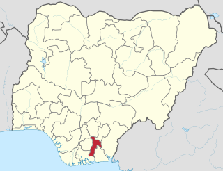
Ebonyi State is a state in the South-East geopolitical zone of Nigeria, bordered to the north and northeast by Benue State, Enugu State to the west, Cross River State to the east and southeast, and Abia State to the southwest. Named for the Abonyi (Aboine) River—a large part of which is in the state's south—Ebonyi State was formed from parts of Abia and Enugu state in 1996 and has its capital as Abakaliki.

Abakaliki is the capital city of Ebonyi State in southeastern Nigeria, located 64 kilometres (40 mi) southeast of Enugu. The inhabitants are primarily members of the Igbo nation. It was the headquarters of the Ogoja province before the creation of the Southeastern State in 1967.

Enugu State is a state in the South-East geopolitical zone of Nigeria, bordered to the north by the states of Benue and Kogi, Ebonyi State to the east and southeast, Abia State to the south, and Anambra State to the west. The state takes its name from its capital and largest city, Enugu. The city acquired township status in 1917 and was called Enugwu-Ngwo. Due to the rapid expansion towards areas owned by other indigenous communities, it was renamed Enugu in 1928.

Nigeria has 774 local government areas (LGAs), each administered by a local government council consisting of a chairman, who is the chief executive, and other elected members, who are referred to as councillors. Each LGA is further subdivided into a minimum of ten and a maximum of twenty wards. A ward is administered by a councillor, who reports directly to the LGA chairman. The councillors fall under the legislative arm of the Local Government, the third tier of government in Nigeria, below the state governments and the federal government.

The Aro people or Aros are an Igbo subgroup that originated from the Arochukwu kingdom in present-day Abia state, Nigeria. The Aros can also be found in about 250 other settlements mostly in the Southeastern Nigeria and adjacent areas. The Aros today are classified as Eastern or Cross River Igbos because of their location, mixed origins, culture, and dialect. Their god, Chukwu Abiama, was a key factor in establishing the Aro Confederacy as a regional power in the Niger Delta and Southeastern Nigeria during the 18th and 19th centuries.
Ezaa or Ezza is a northeastern Igbo sub-group, in Ebonyi State, southeastern Nigeria. The Ezaa are direct descendants of Anakiwha, the progenitor of Umuekumeyi which comprises Nnoyo, Nnodo and Ezekuna respectively. Ezekuna and his wife, Anyigo are known as the parents of Ezza. They are therefore, often referred to as Ezaa Ezekuna. The group is found at the north of Afikpo.
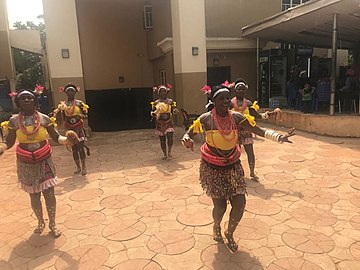
The people of Eddaland, known as the Eddics, are a sub-group of the Igbo people in south-eastern Nigeria. The land and people of Eddaland have been constitutionally designated the present day Afikpo South Local Government Area of Ebonyi State, Nigeria.

Ikom is a Local Government Area of Cross River State in South-South, Nigeria. Its headquarters are in the town of Ikom in the east of the area on the Cross River and the A4 highway at 5°57′40″N8°42′39″E.
Eddalands is an entire local government area in Ebonyi State, Nigeria. It is the most homogeneous LGA in Nigeria with people of one language, one culture and one tradition across the entire LGA.
Afikpo North is a Local Government Area of Ebonyi State, Nigeria. Its headquarters is in the town of Ehugbo, Afikpo. Important townships include Ehugbo Unwana and Amasiri. Other notable areas are Ibii and Akpoha.
Sonni Ogbuoji is a Nigerian politician who was elected Senator for Ebonyi South, in Ebonyi State, Nigeria in the 9 April 2011 national elections. He was elected on the People's Democratic Party (PDP) ticket. He left the senate in the 2019. Sonni hails from Ebunwana Edda in Afikpo South local government area of Ebonyi state.
Godwin Ogbaga is a Nigerian politician and seasoned administrator who was Minister of State for Power and Steel during the short term of Maj. Gen Abdulsalami Abubakar

Unwana, also known as Unwara, is a town and the third-most important urban area in Ebonyi State, Nigeria. It is situated in the southern part of Ebonyi State. It is bordered in the north by Afikpo, in the west by Edda, and in the east by Cross River State. It is the seat of Akanu Ibiam Federal Polytechnic Unwana.
The South East is the one of the six geopolitical zones of Nigeria representing both a geographic and political region of the country's inland southeast. It comprises five states – Abia, Anambra, Ebonyi, Enugu, and Imo.
Priscilla Ekwere Eleje is the first Director of Currency Operations at the Central Bank of Nigeria (CBN). She is the first woman to have her signature appended on the Nigeria Currency, the naira note.
Ebonyi South is one of three senatorial districts in Ebonyi State, Nigeria.

The 2023 Ebonyi State gubernatorial election will take place on 18 March 2023, to elect the Governor of Ebonyi State, concurrent with elections to the Ebonyi State House of Assembly as well as twenty-seven other gubernatorial elections and elections to all other state houses of assembly. The election—which was postponed from its original 11 March date—will be held three weeks after the presidential election and National Assembly elections. Incumbent APC Governor Dave Umahi is term-limited and cannot seek re-election to a third term.
The 2023 Nigerian presidential election in Ebonyi State will be held on 25 February 2023 as part of the nationwide 2023 Nigerian presidential election to elect the president and vice president of Nigeria. Other federal elections, including elections to the House of Representatives and the Senate, will also be held on the same date while state elections will be held two weeks afterward on 11 March.