
Golovin is a city in Nome Census Area, Alaska, United States. At the 2010 census the population was 156, up from 144 in 2000.

Bangor Charter Township is a charter township in Bay County in the U.S. state of Michigan. The township's population was 14,641 as of the 2010 Census and is included in the Bay City Metropolitan Statistical Area.

The Indian River is a 121-mile (195 km) long brackish lagoon in Florida. It is part of the Indian River Lagoon system, which in turn forms part of the Atlantic Intracoastal Waterway. It was originally named Rio de Ais after the Ais Indian tribe, who lived along the east coast of Florida, but was later given its current name.
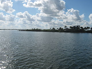
The Banana River is a 31-mile-long (50 km) lagoon that lies between Cape Canaveral and Merritt Island in Brevard County, Florida in the United States. It is part of the Indian River Lagoon system, and connects at its south end to the Indian River; it is the only part of the lagoon system not in the Intracoastal Waterway. It also has an outlet to the Atlantic Ocean via a lock into Port Canaveral. The lagoon includes salt marshes, mangrove swamps, seagrass beds, drift algae, oyster bars, tidal flats, and spoil islands, providing habitats for many marine species. These are brackish waters mixed of salt and fresh water; waist deep with a soft bottom sand/grass. Commercial and recreational activities in the lagoon generate more than US$ 800 million annually for the local economy.

Hāʻena State Park is a state park located on the north shore of the Hawaiian island of Kauaʻi. It is often referred to as the "end of the road" and marks the end point of the Kuhio Highway. The park provides access to beaches, trails, and several ancient Hawaiian sites, including sea caves estimated to be more than 4,000 years old. Archaeological sites associated with the hula, including a heiau (shrine) dedicated to Laka, are located above the park's beaches.

Apalachicola Bay is an estuary and lagoon located on the northwest coast of the U.S. state of Florida. The Apalachicola Bay system also includes St. George Sound, St. Vincent Sound and East Bay, covering an area of about 208 square miles (540 km2). Four islands, St. Vincent Island to the west, Cape St. George Island and St. George Island to the south, and Dog Island to the east, separate the system from the Gulf of Mexico. Water exchange occurs through Indian Pass, West Pass, East Pass and the Duer Channel. The lagoon has been designated as a National Estuarine Research Reserve and the Apalachicola River is the largest source of freshwater to the estuary. Combined with the Chattahoochee River, Flint River, and Ochlockonee River they drain a watershed of over 20,000 square miles (50,000 km2) at a rate of 19,599 cubic feet (550 m3) per second according to the United States Geological Survey in 2002.

Castaic Creek is a 25.0-mile-long (40.2 km) stream in the Sierra Pelona Mountains, in northeastern Los Angeles County, California. It is a tributary of the Santa Clara River.
Jason Harbour is a bay 1 mile (1.6 km) wide, lying west of Allen Bay in the north side of Cumberland West Bay, South Georgia. It was charted and named by the Swedish Antarctic Expedition, 1901–04, under Otto Nordenskiöld. The bay was previously visited by the Jason, Captain C.A. Larsen, in 1894.

Lacon, also known as Cedar Crossing, is a ghost town in extreme southern Morgan County, Alabama, United States. Lacon was named after Lacon, Illinois. Built at the northern foot of Burleson Mountain, alongside the railroad track there, a spring and good clay enabled a substantial brickyard. The Lacon brickyard made bricks with a distinctive mark, "LACON", imprinted on the large sides of the bricks.

Kent Island is a small island in Marin County, California. In 1964 it was proposed for large-scale development including a hotel and marina, but the plan was defeated in 1967. The island is now included in the Greater Farallones National Marine Sanctuary.

Belvedere Island is a rocky island in the San Francisco Bay in Marin County, California which was formerly separated by a marsh from the mainland, though has since been linked by two spits. Part of the town of Belvedere, California is located on the island.
The Icy Cape is a headland on the Chukchi Sea side of the North Slope Borough, Alaska, United States. It was discovered and named by James Cook on August 17, 1778, on account of the ice along the coast.

Isle of Wight Bay is a lagoon that separates part of mainland Worcester County, Maryland from the midtown part of Ocean City, also in Worcester County. To the north, it connects to the Assawoman Bay just south of the Assawoman Bay Bridge, and to the south it connects to the Sinepuxent Bay at the north end of West Ocean City where the bay narrows between the Thoroughfare channel and Mallard Island. The major tributary of Isle of Wight Bay is the St. Martin's River; other tributaries include Turville Creek, Manklin Creek, and Herring Creek.

Big Lagoon is a census-designated place in Humboldt County, California. It is located 7 miles (11 km) north of Trinidad, at an elevation of 56 feet (17 m). The population was 93 at the 2010 census.
Eshpeu is a former Yurok settlement in Humboldt County, California. It was located at Gold Bluff between the mouths of the Klamath River and Redwood Creek. Espa Lagoon is near the site of Eshpeu.
Kachemak Bay State Park and Kachemak Bay State Wilderness Park is a 400,000-acre (1,600 km2) park in and around Kachemak Bay, Alaska, United States. Kachemak Bay State Park was the first legislatively designated state park in the Alaska State Parks system. Kachemak Bay State Wilderness Park is the state's only legislatively designated wilderness park. No road accesses most areas of the park; visitors normally fly in or travel by boat from Homer.

Berry Glacier is an Antarctic glacier, about 25 miles (40 km) long and 5 miles (8 km) wide, draining north between Perry Range and Demas Range into the Getz Ice Shelf on the coast of Marie Byrd Land. This vicinity was first photographed and rudely charted from aircraft of the U.S. Antarctic Service in December 1940, and the glacier was mapped in detail by the U.S. Geological Survey from ground surveys and from U.S. Navy air photos, 1959–66. It was named by the Advisory Committee on Antarctic Names for Commander William H. Berry, U.S. Navy, Air Operations Officer for Task Force 43 during Operation Deep Freeze 1969–72; Operations Officer, 1973.

Winston Glacier is a glacier flowing to Winston Lagoon on the southeast side of Heard Island in the southern Indian Ocean. Its terminus is at Winston Lagoon, between Cape Lockyer and Oatt Rocks. To the northeast of Winston Glacier is Stephenson Glacier, whose terminus is located between Dovers Moraine and Stephenson Lagoon. To the southwest of Winston Glacier is Fiftyone Glacier, whose terminus is located between Lavett Bluff and Lambeth Bluff.

Lagoon Island is the northernmost of the Léonie Islands, lying in the entrance to Ryder Bay on the southeast side of Adelaide Island, Antarctica. It was discovered by the French Antarctic Expedition, 1908–10, under Jean-Baptiste Charcot. The island was charted by the British Graham Land Expedition under John Rymill in February 1936 and was so named because with the island on its west side it forms a lagoon.
Hocomonco Pond is a recreational pond located in Westborough, Massachusetts near Route 9. Also called Hobomoc Pond, it was named for Hobomok, a Wamesit Indian evil spirit. The pond and adjacent land are a Superfund site.

