Ainsdale

Last updated

Ainsdale
Ainsdale Village Church (1).JPG
Ainsdale Village Church
Location map United Kingdom Southport.svg
Red pog.svg
Ainsdale
Location in Southport
Merseyside UK location map.svg
Red pog.svg
Ainsdale
Location within Merseyside
Population12,723 (2001 Census) [1]
OS grid reference SD312122
Metropolitan borough
Metropolitan county
Region
Country England
Sovereign state United Kingdom
Post town SOUTHPORT
Postcode district PR8
Dialling code 01704
Police Merseyside
Fire Merseyside
Ambulance North West
UK Parliament
List of places
UK
England
Merseyside
53°36′08″N3°02′26″W / 53.6021°N 3.0405°W / 53.6021; -3.0405

Ainsdale is an area of Southport in Merseyside, England, situated three miles south of the centre of Southport. Originally in the historic county of Lancashire, at the 2001 Census it had a population of 12,723. [1] By the time of the 2011 census, only figures for Ainsdale (ward) were available.

Contents

It makes up the southern edge of the town, separated from neighbouring Formby by RAF Woodvale. The village and roads leading to the beach are middle class areas, with some new modern developments around the station, including the addition of the private estate Village Row in 2006, and the Belway estate in 2013.

History

Prior to 1600

Ainsdale was listed in the Domesday Book as Einulvesdel. Deriving from Old Norse name Einulfsdalr, this apparently was the valley occupied by a Scandinavian by the name of Einulf. [2] [3]

1600-Present

Ainsdale formed part of Sir Cuthbert Halsall of Halsall's estates during the early part of the 1600s. After financial difficulties the land containing Ainsdale (then Aynsdale) had to be sold. In 1634 the ownership was passed to Robert Blundell. The lands were passed from generation to generation within the Blundell family and remained in their ownership until the mid-1900s. [4]

Throughout the 1800s Ainsdale remained an agricultural community. Prior to the British Agricultural Revolution fields and farms in the locality were small and land was enclosed. The 1841 Census listed 176 inhabitants in 33 houses with occupations of farmer, agricultural labourers and servants. [5]

Ainsdale railway station opened in 1848. A second station was opened in 1901. It was originally named Seaside, being renamed Ainsdale Beach in 1912. It closed in 1952. The route of the line it was on now forms the Coastal Road from Woodvale to Southport. The row of houses over the road from the Sands Hotel were originally railway staff cottages for that line. [6]

Ainsdale became part of the County Borough of Southport in 1912 after being part of Birkdale Urban District, though it remained a separate civil parish to Southport until 1925. Although now in the administrative county of Merseyside it is still in the County Palatine of Lancashire.

Land speed record

On 16 March 1926, Sir Henry Segrave set his first land speed record of 152.33 miles per hour (245.15 km/h) using Ladybird, a 4-litre Sunbeam Tiger on Ainsdale beach. This record was broken a month later by J.G. Parry-Thomas driving Babs, a custom-built car with a 27-litre 450 hp (340 kW) V12 Liberty aero engine.

Governance

The area of Ainsdale, together with the adjoining settlement of Woodvale, and a significant part of Birkdale, forms a single electoral ward named Ainsdale, it is currently represented by three councillors on Sefton Council. [7] As of May 2023, they were Janet Harrison (Labour), Lynne Thompson (Liberal Democrat) and Tony Brough (Conservative).

For parliamentary elections, the ward is part of the Southport constituency, currently represented by the Conservative MP, Damien Moore, who was elected at the 2019 United Kingdom general election. As part of constituency boundary changes effective at the next general election, the town will move into the Sefton Central constituency. [8]

Landmarks

Tower Mill at Ainsdale The Mill at Ainsdale in Lancashire.jpg
Tower Mill at Ainsdale

Ainsdale Mill, built circa 1800 on the site of an earlier wooden mill, was an impressive - and functional - landmark until its closure in 1965 and later demolition. A branch railway line from Ainsdale railway station served the corn mill during its operating years. [9] The original Ainsdale timber post windmill served both Ainsdale and Birkdale and is mentioned in 1631 as being ‘in the possession of Cuthbert Rimmer’, in a lease from Robert Blundell. [10]

Ainsdale boating lake, along with the beach itself, were popular tourist attractions, and thus Lakeside Hotel (now known as The Sands) was built to accommodate those wishing to stay in the area. However, a large campsite was also well populated in the busiest periods of the year.

In the village green there is a war memorial that commemorates the lives of forty-four Ainsdale residents killed as a result of the First World War.The War Memorial was totally refurbished by the Ainsdale Civic Society in 2012 when some missing names of those Ainsdale men killed in action in WW1 and extra plaques were inset on the Memorial to accommodate those lost from WW2 and Afghanistan. It took two years of research and fundraising to complete the second part of the project to restore the monument to its former glory. Space has been left on the memorial for additional names; however, they hope it never needs to be filled.

Transport

The locality is served by Ainsdale railway station, which is situated on the Northern Line of the Merseyrail network, linking Southport to Liverpool. Trains operate every 15 minutes in each direction from early morning to late evening from Monday to Saturday and every 30 minutes on Sundays.

Frequent bus services passing through Ainsdale are provided by Arriva North West, including:
• 44/44A Crossens - Formby
• 47 Crossens - Liverpool (20 minutes weekday daytime, less frequent evenings)
• 49 Crossens - Woodvale (12 minutes daytime, half-hourly evenings, slightly less frequent daytime on Sundays)

Stagecoach provides the X2, running from Preston through Tarleton, Banks, Southport, Birkdale, Ainsdale, Formby, Crosby and Bootle before finishing in Liverpool (half-hourly weekday daytime, restricted in evenings, early finish Sundays). [11]

Recreation and sports

Kitesurfing at Ainsdale beach Ainsdale Beach - geograph.org.uk - 89188.jpg
Kitesurfing at Ainsdale beach

Sport in Ainsdale is represented in various streams such as football, cricket, bowls, pool and chess. The village is also the home of the famous Southport and Ainsdale Golf Club.

The football section of Ainsdale Sports and Social Club namely Southport & Ainsdale Amateurs AFC host teams from Under 6 up to Under 18 and Open Age Teams. The senior first team play in the Premier Division of the Mid Lancashire League. Ainsdale Cricket Club play in the successful Liverpool Competition. The club also has three All weather 3G pitches as part of its set up.

Ainsdale is also home to Hillside Lawn Tennis Club who play in the Southport Tennis League.

Every year at the start of July, Ainsdale Horticultural Society hold a village show. This popular local event showcases local growers produce in an horticultural competition and hosts many other events by local people.

Ainsdale beach is designated by Sefton Council as a kite beach where kitesurfing and land-based kite traction activities are allowed. [12]

The Sefton coastal path and the Trans Pennine Trail both pass through Ainsdale. A number of waymarked nature trails are also accessible from the town. These trails allow access to the Ainsdale Sand Dunes, designated as one of the national nature reserves in England. This nature reserve also comprises part of a Ramsar site. [13] [14]

The publisher Café Royal Books is based in the area.

Notable people

Related Research Articles

<span class="mw-page-title-main">Metropolitan Borough of Sefton</span> Metropolitan borough in England

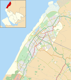
The Metropolitan Borough of Sefton is a metropolitan borough of Merseyside, England. It was formed on 1 April 1974 under the Local Government Act 1972, by the amalgamation of the county boroughs of Bootle and Southport, the municipal borough of Crosby, the urban districts of Formby and Litherland, and part of West Lancashire Rural District. It consists of a coastal strip of land on the Irish Sea which extends from Southport in the north to Bootle in the south, and an inland part to Maghull in the south-east, bounded by the city of Liverpool to the south, the Metropolitan Borough of Knowsley to the south-east, and West Lancashire to the east.

<span class="mw-page-title-main">Southport</span> Town in Merseyside, England

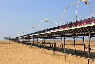
Southport is a seaside town in the Metropolitan Borough of Sefton in Merseyside, England. At the 2021 census, it had a population of 94,421, making it the eleventh most populous settlement in North West England.

<span class="mw-page-title-main">Formby</span> Town in England

Formby is a town and civil parish in the Metropolitan Borough of Sefton, Merseyside, England.

<span class="mw-page-title-main">Birkdale</span> Human settlement in England

Birkdale is an area of Southport, within the Metropolitan Borough of Sefton, Merseyside, though historically in Lancashire, in the north-west of England. The area is located on the Irish Sea coast, approximately a mile away from the centre of Southport. From 1894 to 1912, Birkdale and the adjoining suburb/village of Ainsdale were administered by Birkdale Urban District Council before becoming part of the county borough of Southport. Until 1 April 1974, Birkdale lay in the traditional borders of the county of Lancashire. At the 2001 census, the local government ward called Birkdale had a population of 12,265. The population of the area at the 2011 Census is shown under Birkdale (ward) (qv). Other parts of Birkdale are included in Dukes ward—which contains a significant part of the village centre and the Royal Birkdale Golf Club—Kew and Ainsdale wards.

<span class="mw-page-title-main">Crossens</span> Human settlement in England

Crossens is the northernmost district of the town of Southport, Merseyside, England.

<span class="mw-page-title-main">Freshfield</span> Human settlement in England

Freshfield is an area of Formby, in the Metropolitan Borough of Sefton, Merseyside, England, situated at the northern end of the town. It has no local political distinction or representation and is included as part of the two council wards which make up Formby, nor is it any longer separated in a physical sense from the town.

<span class="mw-page-title-main">Hightown, Merseyside</span> Village in England

Hightown is a village and civil parish in the Metropolitan Borough of Sefton in Merseyside, England, located midway between the city of Liverpool and the coastal resort of Southport. It is 8 miles north of Liverpool city centre and is located on the coast near the boundary of the Mersey Estuary and Liverpool Bay. The River Alt joins the sea at this point and forms an estuary. There is a pumping station on the River Alt at Altmouth, built 1972, as part of a programme to alleviate flooding in the area. This is on the Altcar Rifle Range, a Territorial Army base originally established in 1860 by Lt. Col. Gladstone.

<span class="mw-page-title-main">Liverpool, Crosby and Southport Railway</span>

The Liverpool, Crosby and Southport Railway (LC&SR) received parliamentary authorization on 2 July 1847 and opened between Southport and Liverpool, on 24 July 1848. The Liverpool terminal was a temporary station on the viaduct passing near to Waterloo Goods station.

<span class="mw-page-title-main">Southport (UK Parliament constituency)</span> Parliamentary constituency in the United Kingdom

Southport is a constituency in Merseyside which has been represented in the House of Commons of the UK Parliament since 2017 by Damien Moore of the Conservative Party.

<span class="mw-page-title-main">Halsall</span> Human settlement in England

Halsall is a village and civil parish in West Lancashire, England, located close to Ormskirk on the A5147 and Leeds and Liverpool Canal.

<span class="mw-page-title-main">Birkdale railway station</span> Railway station in Southport, England

Birkdale railway station serves the Birkdale suburb of Southport, England. The station is located on the Southport branch of the Merseyrail network's Northern Line.

<span class="mw-page-title-main">Birkdale Palace railway station</span> Disused railway station in Birkdale, Merseyside

Birkdale Palace railway station was located in Birkdale, Lancashire, England. The station was opened by the Southport & Cheshire Lines Extension Railway in 1884 and closed in 1952.

<span class="mw-page-title-main">Ainsdale Beach railway station</span> Former railway station in Merseyside, England

Ainsdale Beach was a railway station located in Ainsdale, Merseyside, England.

Woodvale railway station was a railway station located in Woodvale, Merseyside, England.

The Southport & Cheshire Lines Extension Railway was an early British railway company operating in the then county of Lancashire. It was constructed to link the Cheshire Lines Committee railway at Aintree to Southport. It operated from 1884 to 1952.

<span class="mw-page-title-main">Altcar and Hillhouse railway station</span> Disused railway station in Great Altcar, Lancashire

Altcar and Hillhouse was a railway station located on the Southport & Cheshire Lines Extension Railway near Great Altcar, Lancashire, England.

Sefton and Maghull railway station was a station located on the Southport & Cheshire Lines Extension Railway on Sefton Lane, Maghull, Merseyside, England.

<span class="mw-page-title-main">Sefton Coast</span>

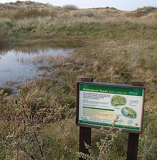
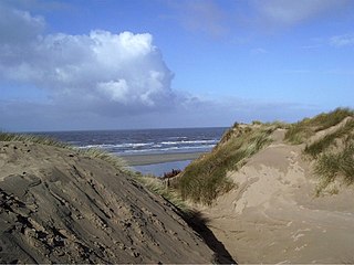
Sefton Coast is a 4605.3 hectare Site of special scientific interest which stretches for 12 miles (20 km) between Southport and Waterloo, which is end location of Crosby Beach. The site was notified in 2000 for both its biological and geological features. The coast has species such as grass of Parnassus, wild orchids, rare butterflies, sand lizards, natterjack toads and waders.

References

  1. 1 2 2001 Census: Ainsdale, Office for National Statistics, archived from the original on 25 May 2011, retrieved 24 October 2007
  2. Ainsdale On-line , retrieved 24 October 2007
  3. Vikings In Lancashire, Formby Civic Society, 4 March 2004, archived from the original on 30 September 2011, retrieved 24 October 2007
  4. Harrop, Sylvia (1985), Old Birkdale and Ainsdale, Birkdale and Ainsdale Historical Research Society, 1st ed., pp. 1–13, ISBN   0-9510905-0-X
  5. Harrop, Sylvia (1985), Old Birkdale and Ainsdale, Birkdale and Ainsdale Historical Research Society, 1st ed., pp. 120–127, ISBN   0-9510905-0-X
  6. Disused Station UK , retrieved 26 July 2015
  7. Your Councillors by Ward Archived 15 May 2010 at the Wayback Machine , Sefton Council. Retrieved on 24 May 2010
  8. "North West | Boundary Commission for England".
  9. "Tower mill, Ainsdale - Images & Documents". catalogue.millsarchive.org. Retrieved 2 April 2020.
  10. Lancs Record Office DDIn/46/4 (Birkdale lease to Richd Rymer alias Black Dick, by lives of Eliz. ‘his now wife’ and Wm his s.)
  11. "X2 - Preston - Southport - Liverpool".
  12. Kitebeach Ainsdale-on-Sea Rules and Conditions of usage, Sefton Metropolitan Borough Council, archived from the original on 26 September 2006, retrieved 23 March 2008
  13. Ramsar sites in the UK, Joint Nature Conservation Committee, retrieved 23 March 2008
  14. Natural England: Special Sites, Natural England, retrieved 23 March 2008