Airspace

Last updated

Airspace [1] is the portion of the atmosphere controlled by a country above its territory, including its territorial waters or, more generally, any specific three-dimensional portion of the atmosphere. [2] It is not the same as outer space which is the expanse or space outside the Earth and aerospace which is the general term for Earth's atmosphere and the outer space within the planet's vicinity.

Contents

Horizontal boundary

The Federal Aviation Administration (FAA) of the United States provides air traffic control services over U.S. territory and over international waters where it has been delegated such authority by the International Civil Aviation Organization. This map depicts overflight fee regions. The yellow regions are where the U.S. provides enroute ATC services (mostly over land territory). The blue regions are where the U.S. provides oceanic ATC services over international waters. US Overflight Fee Map.png
The Federal Aviation Administration (FAA) of the United States provides air traffic control services over U.S. territory and over international waters where it has been delegated such authority by the International Civil Aviation Organization. This map depicts overflight fee regions. The yellow regions are where the U.S. provides enroute ATC services (mostly over land territory). The blue regions are where the U.S. provides oceanic ATC services over international waters.

By international law, a state "has complete and exclusive sovereignty over the airspace above its territory", which corresponds with the maritime definition of territorial waters as being 12 nautical miles (22.2 km) out from a nation's coastline. [3] Airspace not within any country's territorial limit is considered international, analogous to the "high seas" in maritime law.

However, a country may, by international agreement, assume responsibility for controlling parts of international airspace, such as those over the oceans. Such airspace in respect of which a country is responsible under the International Civil Aviation Organization (ICAO) for operational control is called a Flight Information Region (FIR). For a coastal state, the FIR consists of the airspace above its land and sea territory plus any international airspace in respect of which ICAO has assigned responsibility to that state. [4]

For instance, the United States provides air traffic control services over a large part of the Pacific Ocean, even though the airspace is international.

Vertical boundary

There is no international agreement on the vertical extent of sovereign airspace, [5] with suggestions ranging from about 30 km (19 mi)—the extent of the highest aircraft and balloons—to about 160 km (100 mi)—approximately the lowest extent of short-term stable orbits. (The satellite Lixing-1 had a stable orbit with an apogee of 140 km (87 mi) for three days.) [6] The Fédération Aéronautique Internationale has established the Kármán line—at an altitude of 100 km (62 mi)—as the boundary between the Earth's atmosphere and outer space, [7] while the United States considers anyone who has flown above 80 kilometres (50 mi) to be an astronaut [ citation needed ]. Indeed, descending Space Shuttles flew closer than 80 km (50 mi) over other nations, such as Canada, without requesting permission first. [8] Nonetheless, both the Kármán line and the U.S. definition are merely working benchmarks, without any real legal authority over matters of national sovereignty.

Kármán line

The Kármán line (or von Kármán line /vɒnˈkɑːrmɑːn/ ) [9] is a proposed conventional boundary between Earth's atmosphere and outer space.

Until the middle of the 20th century, which was considered the pioneering time of aviation, there were no fixed boundaries as to what was national airspace and when it became international airspace. Because of this, a kind of customary law applied at the time and most countries such as the United Kingdom or the United States considered airspace as international from about 13,000 feet. However, this only applied in times of peace and if it was to the advantage of the states, there was no clear demarcation of the airspace question until the 1950s when the Kármán line was defined. [ citation needed ]

Private air rights

The boundary between public airspace and private air rights is defined by national or local law.

In the United States, the 1946 Supreme Court decision United States v. Causby overturned the common law doctrine that private property rights extend indefinitely upwards, instead ruling that they end 300 feet above the highest terrain (including buildings), the lower limit of the "public highway" defined by Congress in the Air Commerce Act of 1926. The Federal Aviation Administration regulates the construction and marking of structures taller than 200 feet near airports and 500 feet generally. [10]

Controlled airspace

Controlled airspace [11] exists where it is deemed necessary that air traffic control has some form of positive executive control over aircraft flying in that airspace (however, air traffic control does not necessarily control traffic operating under visual flight rules (VFR) [12] within this airspace).

Airspace may be further subdivided into a variety of areas and zones, including those where there are either restrictions on flying activities or complete prohibition of flying activities.

Controlled airspace is a generic term that covers the different classifications of airspace and defined dimensions within which air traffic control (ATC) service is provided in accordance with the airspace classification. Controlled airspace consists of: [13]

Airspace classes in the United States Airspace classes (United States).png
Airspace classes in the United States

Class A airspace

Class A airspace is generally the airspace from 18,000 feet (~3.4 miles, 5.5 km) mean sea level (MSL) up to and including flight level (FL) 600 (~11.4 miles, 18.3 km), including the airspace overlying the waters within 12 nautical miles (NM) (~13.8 miles, 22.2 km) of the coast of the 48 contiguous states and Alaska. Unless otherwise authorized, all operation in Class A airspace is conducted under instrument flight rules (IFR). [13]

Class B airspace

Class B airspace is generally airspace from the surface to 10,000 feet MSL surrounding the nation's busiest airports in terms of airport operations or passenger enplanements. The configuration of each Class B airspace area is individually tailored, consists of a surface area and two or more layers (some Class B airspace areas resemble upside-down wedding cakes), and is designed to contain all published instrument procedures once an aircraft enters the airspace. An ATC clearance is required for all aircraft to operate in the area, and all aircraft that are so cleared receive separation services within the airspace. [13]

Class C airspace

Class C airspace is generally airspace from the surface to 4,000 feet above the airport elevation (charted in MSL) surrounding those airports that have an operational control tower, are serviced by a radar approach control, and have a certain number of IFR operations or passenger enplanements. Although the configuration of each Class C area is individually tailored, the airspace usually consists of a surface area with a five NM radius, an outer circle with a ten NM radius that extends from 1,200 feet to 4,000 feet above the airport elevation, and an outer area. Each aircraft must establish two-way radio communications with the ATC facility providing air traffic services prior to entering the airspace and thereafter maintain those communications while within the airspace. [13]

Class D airspace

Class D airspace is generally airspace from the surface to 2,500 feet above the airport elevation (charted in MSL) surrounding those airports that have an operational control tower. The configuration of each Class D airspace area is individually tailored and when instrument procedures are published, the airspace is normally designed to contain the procedures. Arrival extensions for instrument approach procedures (IAPs) may be Class D or Class E airspace. Unless otherwise authorized, each aircraft must establish two-way radio communications with the ATC facility providing air traffic services prior to entering the airspace and thereafter maintain those communications while in the airspace. [13]

Class E airspace

If the airspace is not Class A, B, C, or D, and is controlled airspace, then it is Class E airspace. Class E airspace extends upward from either the surface or a designated altitude to the overlying or adjacent controlled airspace. When designated as a surface area, the airspace is configured to contain all instrument procedures. Also in this class are federal airways, airspace beginning at either 700 or 1,200 feet above ground level (AGL) used to transition to and from the terminal or en route environment, and en route domestic and offshore airspace areas designated below 18,000 feet MSL. Unless designated at a lower altitude, Class E airspace begins at 14,500 MSL over the United States, including that airspace overlying the waters within 12 NM of the coast of the 48 contiguous states and Alaska, up to but not including 18,000 feet MSL, and the airspace above FL 600. [13] Class E has control services available but VFR pilots are not required to make any contact with ATC unlike other controlled airspace.

Uncontrolled airspace

Class G airspace

Uncontrolled airspace or Class G airspace is the portion of the airspace that has not been designated as Class A, B, C, D, or E. It is therefore designated uncontrolled airspace by the ATC. Class G airspace extends from the surface to the base of the overlying Class E airspace. Although ATC has no authority or responsibility to control air traffic, pilots should remember there are visual flight rules (VFR) minimums which apply to Class G airspace, [13] and that flight over private property should not be presumed valid.

Special use airspace

Special use airspace or special area of operation (SAO) is the designation for airspace in which certain activities must be confined, or where limitations may be imposed on aircraft operations that are not part of those activities. Certain special use airspace areas can create limitations on the mixed use of airspace. The special use airspace depicted on instrument charts includes the area name or number, effective altitude, time and weather conditions of operation, the controlling agency, and the chart panel location. On National Aeronautical Charting Group (NACG) en route charts, this information is available on one of the end panels. [13] Special use airspace usually consists of:

Prohibited areas

Prohibited areas contain airspace of defined dimensions within which the flight of aircraft is prohibited. Such areas are established for security or other reasons associated with the national welfare. Prohibited areas in the United States are published in the Federal Register and are depicted on aeronautical charts. The area is charted as a "P" followed by a number (e.g., P-49). Examples of prohibited areas include Camp David and the National Mall in Washington, D.C., where the White House and the Congressional buildings are located. [13]

Restricted areas

Restricted areas are areas where operations are hazardous to nonparticipating aircraft and contain airspace within which the flight of aircraft, while not wholly prohibited, is subject to restrictions. Activities within these areas must be confined because of their nature, or limitations may be imposed upon aircraft operations that are not a part of those activities, or both. Restricted areas denote the existence of unusual, often invisible, hazards to aircraft (e.g., artillery firing, aerial gunnery, or guided missiles). IFR flights may be authorized to transit the airspace and are routed accordingly. Penetration of restricted areas without authorization from the using or controlling agency may be extremely hazardous to the aircraft and its occupants. [13] ATC facilities apply the following procedures when aircraft are operating on an IFR clearance (including those cleared by ATC to maintain VFR on top) via a route which lies within joint-use restricted airspace:

  1. If the restricted area is not active and has been released to the Federal Aviation Administration (FAA), the ATC facility allows the aircraft to operate in the restricted airspace without issuing specific clearance for it to do so.
  2. If the restricted area is active and has not been released to the FAA, the ATC facility issues a clearance which ensures the aircraft avoids the restricted airspace.

Restricted areas are charted with an "R" followed by a number (e.g., R-4401) and are depicted on the en route chart appropriate for use at the altitude or FL being flown. Restricted area information can be obtained on the back of the chart.

Warning areas

Warning areas are similar in nature to restricted areas; however, the United States government does not have sole jurisdiction over the airspace. A warning area is airspace of defined dimensions, extending from 12 NM outward from the coast of the United States, containing activity that may be hazardous to nonparticipating aircraft. The purpose of such areas is to warn nonparticipating pilots of the potential danger. A warning area may be located over domestic or international waters or both. The airspace is designated with a "W" followed by a number (e.g., W-237). [14]

Military operation areas (MOAs)

MOAs consist of airspace with defined vertical and lateral limits established for the purpose of separating certain military training activities from IFR traffic. Whenever an MOA is being used, nonparticipating IFR traffic may be cleared through an MOA if IFR separation can be provided by ATC. Otherwise, ATC reroutes or restricts nonparticipating IFR traffic. MOAs are depicted on sectional, VFR terminal area, and en route low altitude charts and are not numbered (e.g., "Camden Ridge MOA"). [Figure 14-5] However, the MOA is also further defined on the back of the sectional charts with times of operation, altitudes affected, and the controlling agency. [13]

Alert areas

Alert areas are depicted on aeronautical charts with an "A" followed by a number (e.g., A-211) to inform nonparticipating pilots of areas that may contain a high volume of pilot training or an unusual type of aerial activity. Pilots should exercise caution in alert areas. All activity within an alert area shall be conducted in accordance with regulations, without waiver, and pilots of participating aircraft, as well as pilots transiting the area, shall be equally responsible for collision avoidance. [13]

Controlled firing areas (CFAs)

CFAs contain activities, which, if not conducted in a controlled environment, could be hazardous to nonparticipating aircraft. The difference between CFAs and other special use airspace is that activities must be suspended when a spotter aircraft, radar, or ground lookout position indicates an aircraft might be approaching the area. There is no need to chart CFAs since they do not cause a nonparticipating aircraft to change its flightpath. [13]

Other airspace areas

"Other airspace areas" is a general term referring to the majority of the remaining airspace. [13] It includes:

Local airport advisory (LAA)

A service provided by facilities, which are located on the landing airport, have a discrete ground-to-air communication frequency or the tower frequency when the tower is closed, automated weather reporting with voice broadcasting, and a continuous ASOS/AWOS data display, other continuous direct reading instruments, or manual observations available to the specialist. [13]

Military training routes (MTRs)

MTRs are routes used by military aircraft to maintain proficiency in tactical flying. These routes are usually established below 10,000 feet MSL for operations at speeds in excess of 250 knots. Some route segments may be defined at higher altitudes for purposes of route continuity. Routes are identified as IFR (IR), and VFR (VR), followed by a number. [Figure 14-7] MTRs with no segment above 1,500 feet AGL are identified by four number characters (e.g., IR1206, VR1207). MTRs that include one or more segments above 1,500 feet AGL are identified by three number characters (e.g., IR206, VR207). IFR low altitude en route charts depict all IR routes and all VR routes that accommodate operations above 1,500 feet AGL. IR routes are conducted in accordance with IFR regardless of weather conditions. VFR sectional charts depict military training activities such as IR, VR, MOA, restricted area, warning area, and alert area information. [13]

Temporary flight restrictions (TFR)

A flight data center (FDC) Notice to Airmen (NOTAM) is issued to designate a TFR. The NOTAM begins with the phrase "FLIGHT RESTRICTIONS" followed by the location of the temporary restriction, effective time period, area defined in statute miles, and altitudes affected. The NOTAM also contains the FAA coordination facility and telephone number, the reason for the restriction, and any other information deemed appropriate. The pilot should check the NOTAMs as part of flight planning. [13]

Some of the purposes for establishing a TFR are:

Since the events of September 11, 2001, the use of TFRs has become much more common. There have been a number of incidents of aircraft incursions into TFRs, which have resulted in pilots undergoing security investigations and certificate suspensions. It is a pilot's responsibility to be aware of TFRs in their proposed area of flight. One way to check is to visit the FAA website(), and verify that there is not a TFR in the area. [13]

Parachute jump aircraft operations

Parachute jump aircraft operations are published in the Airport/Facility Directory (A/FD). Sites that are used frequently are depicted on sectional charts. [13]

Published VFR routes

Published VFR routes are for transitioning around, under, or through some complex airspace. Terms such as VFR flyway, VFR corridor, Class B airspace VFR transition route, and terminal area VFR route have been applied to such routes. These routes are generally found on VFR terminal area planning charts. [13]

Terminal radar service areas (TRSAs)

TRSAs are areas where participating pilots can receive additional radar services. The purpose of the service is to provide separation between all IFR operations and participating VFR aircraft. [13]

The primary airport(s) within the TRSA become(s) Class D airspace. The remaining portion of the TRSA overlies other controlled airspace, which is normally Class E airspace beginning at 700 or 1,200 feet and established to transition to/from the en route/terminal environment. TRSAs are depicted on VFR sectional charts and terminal area charts with a solid black line and altitudes for each segment. The Class D portion is charted with a blue segmented line. Participation in TRSA services is voluntary; however, pilots operating under VFR are encouraged to contact the radar approach control and take advantage of TRSA service. [13]

National Security Areas (NSAs)

NSAs consist of airspace of defined vertical and lateral dimensions established at locations where there is a requirement for increased security and safety of ground facilities. Flight in NSAs may be temporarily prohibited by regulation under the provisions of Title 14 of the Code of Federal Regulations (14 CFR) part 99, and prohibitions are disseminated via NOTAM. Pilots are requested to voluntarily avoid flying through these depicted areas. [13]

See also

Related Research Articles

<span class="mw-page-title-main">Instrument flight rules</span> Civil aviation regulations for flight on instruments

In aviation, instrument flight rules (IFR) is one of two sets of regulations governing all aspects of civil aviation aircraft operations; the other is visual flight rules (VFR).

In aviation, visual flight rules (VFR) are a set of regulations under which a pilot operates an aircraft in weather conditions generally clear enough to allow the pilot to see where the aircraft is going. Specifically, the weather must be better than basic VFR weather minima, i.e., in visual meteorological conditions (VMC), as specified in the rules of the relevant aviation authority. The pilot must be able to operate the aircraft with visual reference to the ground, and by visually avoiding obstructions and other aircraft.

<span class="mw-page-title-main">Air traffic control</span> Service to direct pilots of aircraft

Air traffic control (ATC) is a service provided by ground-based air traffic controllers (people) who direct aircraft on the ground and through a given section of controlled airspace, and can provide advisory services to aircraft in non-controlled airspace. The primary purpose of ATC worldwide is to prevent collisions, organise and expedite the flow of traffic in the air, and provide information and other support for pilots.

The Federal Aviation Regulations (FARs) are rules prescribed by the Federal Aviation Administration (FAA) governing all aviation activities in the United States. The FARs comprise Title 14 of the Code of Federal Regulations. A wide variety of activities are regulated, such as aircraft design and maintenance, typical airline flights, pilot training activities, hot-air ballooning, lighter-than-air aircraft, man-made structure heights, obstruction lighting and marking, model rocket launches, commercial space operations, model aircraft operations, Unmanned Aircraft Systems (UAS) and kite flying. The rules are designed to promote safe aviation, protecting pilots, flight attendants, passengers and the general public from unnecessary risk.

<span class="mw-page-title-main">Visual meteorological conditions</span> Flight category allowing pilots to fly using vision as well as instruments

In aviation, visual meteorological conditions (VMC) is an aviation flight category in which visual flight rules (VFR) flight is permitted—that is, conditions in which pilots have sufficient visibility to fly the aircraft maintaining visual separation from terrain and other aircraft. They are the opposite of instrument meteorological conditions (IMC). The boundary criteria between IMC and VMC are known as the VMC minima and are defined by: visibility, cloud ceilings, and cloud clearances.

<span class="mw-page-title-main">Flight plan</span> Document filed by a pilot or flight dispatcher indicating the aircrafts flight path

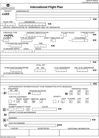
Flight plans are documents filed by a pilot or flight dispatcher with the local Air Navigation Service Provider prior to departure which indicate the plane's planned route or flight path. Flight plan format is specified in ICAO Doc 4444. They generally include basic information such as departure and arrival points, estimated time en route, alternate airports in case of bad weather, type of flight, the pilot's information, number of people on board, and information about the aircraft itself. In most countries, flight plans are required for flights under IFR, but may be optional for flying VFR unless crossing international borders. Flight plans are highly recommended, especially when flying over inhospitable areas such as water, as they provide a way of alerting rescuers if the flight is overdue. In the United States and Canada, when an aircraft is crossing the Air Defense Identification Zone (ADIZ), either an IFR or a special type of VFR flight plan called a DVFR flight plan must be filed. For IFR flights, flight plans are used by air traffic control to initiate tracking and routing services. For VFR flights, their only purpose is to provide needed information should search and rescue operations be required, or for use by air traffic control when flying in a "Special Flight Rules Area."

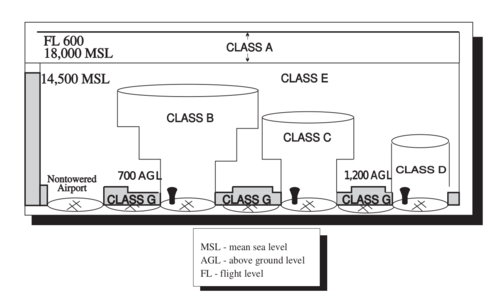
The world's navigable airspace is divided into three-dimensional segments, each of which is assigned to a specific class. Most nations adhere to the classification specified by the International Civil Aviation Organization (ICAO) and described below, though they might use only some of the classes defined below, and significantly alter the exact rules and requirements. Similarly, individual nations may also designate special use airspace (SUA) with further rules for reasons of national security or safety.

<span class="mw-page-title-main">Canadian airspace</span>

Canadian airspace is the region of airspace above the surface of the Earth within which Canada has jurisdiction. It falls within a region roughly defined as either the Canadian land mass, the Canadian Arctic or the Canadian archipelago, and areas of the high seas. Airspace is managed by Nav Canada and detailed information regarding exact dimensions and classification is available in the Designated Airspace Handbook which is published every fifty-six days by Nav Canada.

Special visual flight rules are a set of aviation regulations under which a pilot may operate an aircraft. It is a special case of operating under visual flight rules (VFR).

<span class="mw-page-title-main">Allegheny Airlines Flight 853</span> 1969 mid-air collision

Allegheny Airlines Flight 853 was a regularly scheduled Allegheny Airlines flight from Boston, Massachusetts, to St. Louis, Missouri, with stops in Baltimore, Maryland, Cincinnati, Ohio, and Indianapolis, Indiana. On September 9, 1969, the aircraft serving the flight, a McDonnell Douglas DC-9, collided in mid-air with a Piper PA-28 light aircraft near Fairland, Indiana. The DC-9 was carrying 78 passengers and 4 crew members, and the Piper was leased to a student pilot on a solo cross-country flight. All 83 occupants of both aircraft were killed in the accident and both aircraft were destroyed.

<span class="mw-page-title-main">Non-towered airport</span> Airport without an air traffic control tower

In aviation, a non-towered airport is an airport without a control tower, or air traffic control (ATC) unit. The vast majority of the world's airports are non-towered. In the United States, there are close to 20,000 non-towered airports compared to approximately 500 airports with control towers. Airports with a control tower without 24/7 ATC service follow non-towered airport procedures when the tower is closed but the airport remains open, for example at night.

<span class="mw-page-title-main">Military operations area</span>

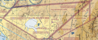
A military operations area (MOA) is an airspace established outside Class A airspace to separate or segregate certain nonhazardous military activities from IFR Traffic and to identify for VFR traffic where these activities are conducted. Similar structures exist under international flight standards. These are designed for routine training or testing maneuvers. Areas near actual combat or other military emergencies are generally designated as restricted airspace. See Temporary Flight Restriction (TFR).

<span class="mw-page-title-main">Special use airspace</span>

Special use airspace (SUA) is a type of special airspaces in the United States designated for operations of a nature such that limitations may be imposed on aircraft not participating in those operations. Often these operations are of a military nature. The designation of SUAs identifies for other users the areas where such activity occurs, provides for segregation of that activity from other users, and allows charting to keep airspace users informed of potential hazards.

An aeronautical chart is a map designed to assist in the navigation of aircraft, much as nautical charts do for watercraft, or a roadmap does for drivers. Using these charts and other tools, pilots are able to determine their position, safe altitude, best route to a destination, navigation aids along the way, alternative landing areas in case of an in-flight emergency, and other useful information such as radio frequencies and airspace boundaries. There are charts for all land masses on Earth, and long-distance charts for trans-oceanic travel.

<span class="mw-page-title-main">Airspace class (United States)</span> U.S. airspace system classification scheme

The United States airspace system's classification scheme is intended to maximize pilot flexibility within acceptable levels of risk appropriate to the type of operation and traffic density within that class of airspace – in particular to provide separation and active control in areas of dense or high-speed flight operations.

In United States aviation, a terminal radar service area (TRSA) is a delimited airspace where radar and air traffic control services are made available to pilots flying under instrument flight rules or (optionally) visual flight rules, to maintain aircraft separation.

In United States aviation, a special flight rules area (SFRA) is a region in which the normal regulations of flight do not apply in whole or in part, especially regulations concerning airspace classification, altitude, course, and speed restrictions, and the like.

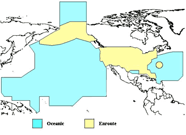
The National Airspace System (NAS) is the airspace, navigation facilities and airports of the United States along with their associated information, services, rules, regulations, policies, procedures, personnel and equipment. It includes components shared jointly with the military. It is one of the most complex aviation systems in the world, and services air travel in the United States and over large portions of the world's oceans.

Military training routes are aerial corridors across the United States in which military aircraft can operate below 10,000 feet faster than the maximum safe speed of 250 knots that all other aircraft are restricted to while operating below 10,000 feet. The routes are the result of a joint venture between the Federal Aviation Administration and the Department of Defense to provide for high-speed, low-altitude military activities.

Toronto Area Control Center is one of seven area control centers in Canada operated by Nav Canada. The Toronto Area Control Centre is based near Toronto Pearson International Airport in Mississauga, Ontario.

References

  1. "AIM Chapter 3. Airspace". Archived from the original on 7 June 2014.
  2. Wragg, David W. (1974). A Dictionary of Aviation (1st American ed.). New York: Frederick Fell, Inc. p. 29. ISBN   0-85045-163-9.
  3. "Convention on an International Civil Aviation" (PDF). Retrieved 21 June 2019.
  4. "The Legal Principles Governing the Control of National Airspace and Flight Information Regions and their Application to the Eastern Mediterranean" (PDF). Retrieved 21 June 2019.
  5. Harris, Alexandra; Harris, Ray (2006). "The need for air space and outer space demarcation". Space Policy. 22 (1): 3–7. doi:10.1016/j.spacepol.2005.11.004.
  6. "Lixing 1".
  7. Sanz Fernández de Córdoba, Dr. S. (24 June 2004). "The 100 km Boundary for Astronautics". Fédération aéronautique internationale. Retrieved 28 December 2020.
  8. White, Robert E. "'Space Weapons Ban: Thoughts on a New Treaty". Archived from the original on 15 May 2008. Retrieved 27 July 2007.
  9. "von-karman". Dictionary.com Unabridged (Online). n.d.
  10. "FAA Updates Airspace Obstructions Standards". 8 December 2015.
  11. "AIM Section 2. Controlled Airspace". Archived from the original on 7 June 2014.
  12. "Pilot/Controller Glossary – VISUAL FLIGHT RULES". Archived from the original on 18 December 2014.
  13. 1 2 3 4 5 6 7 8 9 10 11 12 13 14 15 16 17 18 19 20 21 22 23 Federal Aviation Administration, U.S. Department of Transportation (2008). "Pilot's Handbook of Aeronautical Knowledge; FAA-H-8083-25A" (PDF). Flight Standard Services. pp. 14–2 to 14–16. Archived (PDF) from the original on 30 April 2017.PD-icon.svg This article incorporates text from this source, which is in the public domain .
  14. "Chapter 15: Airspace". Pilot's Handbook of Aeronautical Knowledge (FAA-H-8083-25C ed.). Federal Aviation Administration. 17 July 2023. p. 4.