
Malmö is the largest city in the Swedish county of Scania (Skåne). It is the third-largest city in Sweden, after Stockholm and Gothenburg, and the sixth-largest city in the Nordic region, with a municipal population of 357,377 in 2022. The Malmö Metropolitan Region is home to over 700,000 people, and the Öresund Region, which includes Malmö and Copenhagen, is home to four million people.

Järfälla Municipality is a municipality in Stockholm County in east central Sweden, and is considered a suburb of Stockholm. Its seat is located in Jakobsberg, part of the Stockholm urban area.

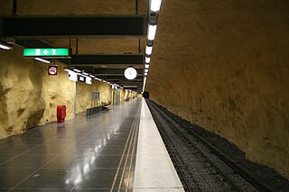
The Stockholm Metro is a rapid transit system in Stockholm, Sweden. The first line opened in 1950 as the first metro line in the Nordic countries, and today the system has 100 stations in use, of which 47 are underground and 53 above ground. There are three coloured lines, as shown on the tube maps, which form seven numbered routes with different termini. Routes numbered 17, 18 and 19, 13 and 14 and 10 and 11 all go through the centre of the city, resulting in a very centralized system. All three lines and seven routes interchange at T-Centralen station. Apart from this, there are three other interchange between lines, at Fridhemsplan, Slussen and Gamla stan stations.
Rinkeby is a district in the Rinkeby-Kista borough, Stockholm, Sweden. Rinkeby had 19,349 inhabitants in 2016. The neighbourhood was part of the Million Programme.
Vällingby is a suburban district in Västerort in the western part of Stockholm Municipality, Sweden.

Bagarmossen is a district within Skarpnäck borough of Stockholm, Sweden. Bagarmossen had 10 914 inhabitants as of December 31, 2009.

Hallonbergen is a suburb of Stockholm, Sweden.

Kymlinge is an area of Sundbyberg Municipality, Stockholm County, Sweden. It is mostly a recreational park, part of which is a nature reserve (Igelbäcken).

Tvärbanan is a light-rail line in Stockholm, Sweden. Its name literally translates to The transverse line, as it operates crosswise to the otherwise radial metro and commuter rail lines of Stockholm. It links together several transit lines through its connections with the southern, western and northern subway branches of the Stockholm Metro (Tunnelbana) as well as three branches of the Stockholm commuter rail (Pendeltåg). The possibility to travel between southern, western and northern greater Stockholm without having to enter the city centre significantly reduces the number of transit passengers, also reducing the number of trains having to pass through the Old Town bottleneck during peak hours. Near Liljeholmen the track is shared with freight traffic for a short section, this being the only place in Sweden where freight traffic and trams share the same track.

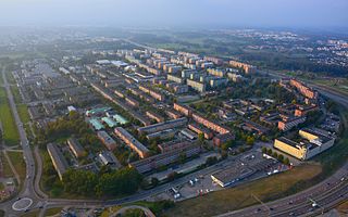
Spånga-Tensta is a borough (stadsdelsområde) located in Västerort in the western part of Stockholm, Sweden. The districts that make up the borough are Bromsten, Flysta, Lunda, Solhem, Sundby and Tensta. A large portion of Järvafältet is also located in Spånga-Tensta as well as in the districts of Akalla and Husby in neighboring Rinkeby-Kista borough.

Barkarby Airport was a disbanded Swedish Air Force base, near Akalla north of Stockholm used for general aviation. Barkarby Airport was one of Sweden’s oldest active airports until it was closed in 2010. A large shopping complex is still situated close to – and partly on – the airfield. Current plans are to construct houses, apartments and offices on large parts of the airfield. December 2008 was due to be the last commercial flight date, after which houses were due to be built. Due to legal complexities about the cancellation of the contract, however, the airport was open for another two years. The airport was finally closed in June 2010.

Hammarbyhöjden is a city district in Stockholm, Sweden. The district is split across two boroughs: Most of it is located in Skarpnäck borough, the subdistrict Blåsut is located in the Enskede-Årsta-Vantör borough. As of December 31, 2007, Hammarbyhöjden had 8,143 inhabitants.
Hökarängen is a district in the Farsta borough of southern Stockholm. It neighbours Fagersjö to the west, Farsta to the south, Sköndal to the east and Gubbängen to the north. As of 2017, the total population of Hökarängen is 9,564
Björkhagen is a district in Skarpnäck borough, Stockholm, Sweden. Björkhagen has 5,695 inhabitants as of December 31, 2007.

Barkarby is a district of Järfälla Municipality, Stockholm County, Sweden and part of the contiguously built-up Stockholm urban area.

Svea Air Corps, also F 8 Barkarby, or simply F 8, is a former Swedish Air Force air corps wing with the main base located in Barkarby just north of the capital Stockholm on the east coast.

Rinkeby-Kista is a borough (stadsdelsområde) in Stockholm, Sweden. The borough is located in Västerort.

Husby is a district in Rinkeby-Kista borough, Stockholm, Sweden. Husby has 11,551 inhabitants as of December 31, 2007.
Akalla is a station in the Stockholm metro in the Akalla district of Stockholm. The station was opened on 5 June 1977 as the northern terminus of the extension of the Blue line from Hallonbergen. This is the final stop on Line 11 of the Blue Line.

The Blue line is one of the three Stockholm Metro lines. It is 25.5 kilometres long, and runs from Kungsträdgården via T-Centralen to Västra skogen where it branches in two, and continues to Hjulsta and Akalla as lines 10 and 11 respectively.

