
Regina is the capital city of the Canadian province of Saskatchewan. The city is the second-largest in the province, after Saskatoon, and is a commercial centre for southern Saskatchewan. As of the 2016 census, Regina had a city population of 215,106, and a Metropolitan Area population of 236,481. Statistics Canada has estimated the CMA's population to be 263,184 as of 2020. It is governed by Regina City Council. The city is surrounded by the Rural Municipality of Sherwood No. 159.
There are many roads in the southwestern part of British Columbia and Vancouver Island that were designated as Highway 1A. These roads were sections of the original 1941 route of Highway 1 before its various re-alignments, and are used today as service routes and frontage roads. The "B.C. Highway 1A" designations were removed from these sections by the province between 2005 and 2010, although signage remains along some of the route and the designation on some maps.
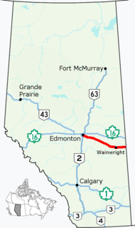
Alberta Provincial Highway No. 14, commonly referred to as Highway 14, is an east-west highway in central Alberta, Canada. It stretches from Edmonton through Wainwright to the Alberta–Saskatchewan border, running parallel to the more northern Highway 16. Highway 14 is about 257 kilometres (160 mi) long.
Highway 219 is a secondary highway in the Canadian province of Saskatchewan, running from the Gardiner Dam development and the north end of Lake Diefenbaker north to Saskatoon.
Ring Road is a 4 lane controlled access highway in Regina, Saskatchewan, Canada. Ring Road is a partial ring road or beltway that forms a partial circle around Regina, bypasses the city on the north, east, and south sides, with Lewvan Drive and Pasqua Street N functioning as the de facto western leg. East of Pasqua Street, Ring Road continues west as 9th Avenue N, an arterial road. Ring Road has a speed limit of 100 km/h (60 mph) and consists of 13 interchanges.
Victoria Avenue is one of the main east-west streets in Regina, Saskatchewan, Canada. Victoria Avenue is named in honour of Queen Victoria and crosses Albert Street, in downtown. It is the main eastern entrance into Regina.

Highway 11 is a major north-south highway in Saskatchewan, Canada that connects the province's three largest cities: Regina, Saskatoon and Prince Albert. It is a structural pavement major arterial highway which is approximately 391 kilometres (243 mi) long. It is also known as the Louis Riel Trail (LRT) after the 19th century Métis leader. It runs from Highway 1 in Regina until Highway 2 south of Prince Albert. Historically the southern portion between Regina and Saskatoon was Provincial Highway 11, and followed the Dominion Survey lines on the square, and the northern portion between Saskatoon and Prince Albert was Provincial Highway 12.
Highway 6 is a paved undivided major provincial highway in the Canadian province of Saskatchewan. It runs from Montana Highway 16 at the Canada–US border near the Canada customs port of Regway to Highway 55 near Choiceland. Highway 6 is about 523 km (325 mi) long. The CanAm Highway comprises Saskatchewan Highways from south to north: SK 35, Sk 39, Sk 6, Sk 3, as well as Sk 2. 330 kilometres (210 mi) of Saskatchewan Highway 6 contribute to the CanAm Highway between Corinne and Melfort.
Highway 46 is a highway in the Canadian province of Saskatchewan. It runs from the Ring Road at Regina to Highway 1 and Highway 364 near Balgonie; it is about 22 km (14 mi) long. Highway 46 intersects Highway 362 and Highway 624 and passes through the communities of Pilot Butte and Balgonie; it is known as McDonald Street within Regina city limits.
Highway 730 is a highway in the Canadian province of Saskatchewan. It runs from Highway 642 near Stony Beach to Regina, where it becomes Dewdney Avenue. Highway 730 is about 28 kilometres (17 mi) long.

Seven neighbourhoods are of considerable note:
Highway 33 is a highway in the southern portion of the Canadian province of Saskatchewan connecting Regina to Stoughton; the highway is divided near Regina. Highway 33 is about 139 km (86 mi) long.

Several special routes of U.S. Route 1 exist, from Florida to Maine. In order from south to north, separated by type, these special routes are as follows.
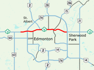
Yellowhead Trail is a 24.6-kilometre (15.3 mi) expressway segment of the Yellowhead Highway in northern Edmonton, Alberta, Canada. It carries a significant amount of truck traffic to and from the industrial areas of north Edmonton and serves as a key commuter route for the bedroom communities of Stony Plain, Spruce Grove, and Sherwood Park, carrying nearly 80,000 vehicles per weekday in 2015. A suburban bypass of the route was completed when the northeast leg of Anthony Henday Drive (Highway 216) opened in late 2016, providing an alternate route through north Edmonton.

Several special routes of U.S. Route 25 exist. In order from south to north they are as follows.

16 Avenue N is a major road in Calgary, Alberta, that forms a 26.5-kilometre (16.5 mi) segment of Highway 1 and connects Calgary to Banff and Medicine Hat. It is a four to six-lane principal arterial expressway at its extremities, but is an urban arterial road between the Bow River and Bowness Road, and also between Crowchild Trail and Deerfoot Trail. Due to Calgary's quadrant system, it is known as 16 Avenue NW west of Centre Street and 16 Avenue NE to the east.
Lewvan Drive and Pasqua Street is a major north–south roadway in west Regina, Saskatchewan. The roadway functions at the western portion of Ring Road; however, unlike Ring Road, it is an arterial road with no interchanges.
Calgary Trail and Gateway Boulevard are a pair of major arterial roadways in Edmonton, Alberta. Gateway Boulevard carries northbound traffic while Calgary Trail carries southbound traffic. From south of 31 Avenue, they form a two-way freeway separated by a median; for this portion, the roadway maintains the separate names for northbound and southbound traffic. Near 31 Avenue, Calgary Trail and Gateway Boulevard separate and become parallel one-way arterial roadways to Saskatchewan Drive, at the edge of the North Saskatchewan River valley. Designated as part of Highway 2 south of Whitemud Drive, it is Edmonton's main southern entrance and is both a major commuter route, connecting to the Edmonton International Airport and Leduc, as well as a regional connection to Red Deer and Calgary.
Highway 11A is a short freeway in the Canadian province of Saskatchewan serving the city of Regina. It runs from the Highway 6 at Regina's northern city limit to Highway 11, 7 km (4 mi) northwest of Regina. It is the original configuration for Highway 11 as it approached Regina and was designated after the Regina Bypass was opened in 2019.