Alcolu, South Carolina

Last updated

Alcolu, South Carolina
USA South Carolina location map.svg
Red pog.svg
Alcolu
Usa edcp location map.svg
Red pog.svg
Alcolu
Coordinates: 33°45′04″N80°12′51″W / 33.75111°N 80.21417°W / 33.75111; -80.21417
Country Flag of the United States (23px).png  United States
State Flag of South Carolina.svg  South Carolina
County Clarendon
Area
[1]
  Total4.57 sq mi (11.84 km2)
  Land4.55 sq mi (11.78 km2)
  Water0.02 sq mi (0.06 km2)
Elevation
125 ft (38 m)
Population
 (2020) [2]
  Total402
  Density88.37/sq mi (34.12/km2)
Time zone UTC-5 (Eastern (EST))
  Summer (DST) UTC-4 (EDT)
ZIP code
29001
Area codes 803, 839
GNIS feature ID1230998 [3]

Alcolu is an unincorporated community and census-designated place (CDP) in Clarendon County, South Carolina, United States. As of the 2010 census, its population was 429. [4] Alcolu has a post office with ZIP code 29001, which opened on August 17, 1888. [5] [6] It developed as a lumber and mill town.

Contents

History

Early History

Alcolu was established between 1885 and 1890 by D.W. Alderman as a company mill town; it was developed to house the employees of his timber company and lumber mill. These were located in a relatively isolated area. The name Alcolu is derived from "AL" for Alderman, "CO" for Coldwell (a friend), and "LU" for Lula, [7] then the only daughter of D.W. Alderman and his wife.

When it was built, Alcolu was a company town where everybody worked in one of the various businesses of D.W. Alderman & Sons. The business grew to encompass logging operations, a saw mill, planing mill, hosiery mill, flooring mill, and extensive farming and cattle ranching. They also ran a cotton gin, hotel, company store, and several other businesses. Over time, the company helped found schools and churches, and built baseball fields, an electric plant, and a telephone system for the town. D.W. Alderman also founded the Alcolu and the Paroda railroads, and built the Alcolu railroad depot. The Alcolu Post Office was established on August 17, 1888. His friend Algernon Coldwell was appointed as its first Postmaster.

Company employees were paid in "babbits", a metal coin stamped with an "A", which could be used only in the company store. There they could buy groceries, see the doctor, get a haircut, or watch a show in the 200-seat auditorium upstairs. In 1919, the company opened the "Alderman 20 Stores in One" in nearby Manning, South Carolina. It was one of the first department stores in South Carolina and boasted of having the first elevator in town.

Execution of George Stinney

The site came to its attention to the scene on March 22, 1944, when two girls Betty June Binnicker, aged 11, and Mary Thames, aged 7, were found dead after being murdered. Notably, 14-year-old George Stinney was wrongly found guilty of their murder and became the youngest person to be executed in the United States since 12-year old Hannah Ocuish in 1786. The decision was vacated in 2014. [8]

Post-War History

In 1947, the Alderman family sold the lumber mill to the Southern Coatings & Chemical Company and the Williams Furniture Company. They, in turn, were bought more than two decades later in 1968 by the Georgia-Pacific company. Georgia-Pacific continued its operations in Alcolu until 2000, when the mill was finally closed. According to the 2010 census, the unincorporated town of Alcolu had a population of 429 people.

Geography

Alcolu is located in northern Clarendon County, 4 miles (6 km) north of Manning, the county seat. The southern edge of the CDP follows Interstate 95, which provides access at Exit 122. I-95 leads northeast 44 miles (71 km) to Florence and southwest 24 miles (39 km) to Santee. U.S. Route 521 runs through Alcolu, leading south to Manning and northwest 16 miles (26 km) to Sumter.

According to the U.S. Census Bureau, the Alcolu CDP has a total area of 4.57 square miles (11.84 km2), of which 4.55 square miles (11.78 km2) is land and 0.02 square miles (0.06 km2), or 0.47%, is water. [4]

Demographics

Historical population
CensusPop.Note
2020 402
U.S. Decennial Census [9]

Notable people

Related Research Articles

<span class="mw-page-title-main">Clarendon County, South Carolina</span> County in South Carolina, United States

Clarendon County is a county located below the fall line in the Coastal Plain region of U.S. state of South Carolina. As of the 2020 census, its population was 31,144. Its county seat is Manning.

<span class="mw-page-title-main">Slater-Marietta, South Carolina</span> Census-designated place in South Carolina, United States

Slater-Marietta is a census-designated place (CDP) in Greenville County, South Carolina, United States, along the North Saluda River. At the 2000 census, there were 2,228 people. At the 2010 census, there were 2,176. At the 2020 census, there were 1,873. It is part of the Greenville–Mauldin–Easley Metropolitan Statistical Area.

<span class="mw-page-title-main">Bucksport, South Carolina</span> Census-designated place in South Carolina, United States

Bucksport is an unincorporated community and census-designated place (CDP) in Horry County, South Carolina, United States. The population was 876 at the 2010 census. It is a rural port on the Atlantic Intracoastal Waterway at the merger point with the Waccamaw River. The port has some services available for boaters and is also home to the Bucksport Restaurant.

<span class="mw-page-title-main">Watts Mills, South Carolina</span> Census-designated place in South Carolina, United States

Wattsville is an unincorporated community in Laurens County, South Carolina, United States. The town name is derived from Watts Mill, a textile mill in the center of town. The area is listed as the Wattsville census-designated place (CDP) for statistical purposes. The population of the CDP was 1,635 at the 2010 census. It is part of the Greenville–Mauldin–Easley Metropolitan Statistical Area.

<span class="mw-page-title-main">Port Hadlock-Irondale, Washington</span> Census-designated place in Washington, United States

Port Hadlock-Irondale is a census-designated place (CDP) in Jefferson County, Washington, United States. The population was 3,983 at the 2020 census.

<span class="mw-page-title-main">Cottage Lake, Washington</span> Census-designated place in Washington, United States

Cottage Lake is a census-designated place (CDP) in King County, Washington, United States. The population was 22,494 at the 2010 census. The lake itself falls within the 98072 ZIP code, while the developments east of the lake fall under the 98077 ZIP code.

<span class="mw-page-title-main">Piedmont, South Carolina</span> CDP in South Carolina, United States

Piedmont is a census-designated place (CDP) along the Saluda River in Anderson and Greenville counties in the U.S. state of South Carolina. The population was 5,411 at the 2020 census.

Arcadia is an unincorporated community and census-designated place (CDP) in Arcadia Township, Manistee County, Michigan, United States. Its population was 309 as of the 2020 census. The community is located along M-22 and the Lake Michigan shore. Arcadia has a post office with ZIP code 49613.

Wellston is an unincorporated community and census-designated place (CDP) in Norman Township, Manistee County, Michigan, United States. Its population was 254 as of the 2020 census, down from 311 in 2010. The community is in the Manistee National Forest just south of M-55, about 21 miles (34 km) east of Manistee and about 29 miles (47 km) west of Cadillac. Wellston has a post office with ZIP code 49689.

<span class="mw-page-title-main">Cascadia, Oregon</span> Unincorporated community in Oregon, US

Cascadia is an unincorporated community and census-designated place (CDP) that was established in 1892 on the South Santiam River, 14 miles (23 km) east of the current city of Sweet Home, in Linn County, Oregon, United States. As of the 2010 census it had a population of 147.

<span class="mw-page-title-main">Moncure, North Carolina</span> Census-designated place in North Carolina, United States

Moncure, founded in 1881, is a small rural unincorporated community in southeastern Chatham County, North Carolina, United States. Moncure and the neighboring community of Haywood form the Moncure census-designated place (CDP), which had a population of 711 at the 2010 census. The community is located near the confluence of the Deep and Haw rivers, which form the Cape Fear River. Moncure once served as the westernmost inland port in the state, linked to the Atlantic Ocean by steamships.

<span class="mw-page-title-main">George Stinney</span> African-American death row victim (1929–1944)

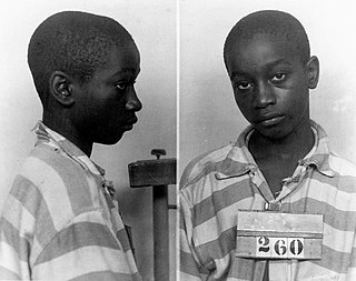
George Junius Stinney Jr. was an African American boy who, at the age of 14, was convicted and then executed in a proceeding later vacated as an unfair trial for the murders of two young white girls in March 1944 – Betty June Binnicker, age 11, and Mary Emma Thames, age 8 – in his hometown of Alcolu, South Carolina. He was convicted, sentenced to death, and executed by electric chair in June 1944, thus becoming the youngest American with an exact birth date confirmed to be both sentenced to death and executed in the 20th century.

Earling is an unincorporated community and census-designated place (CDP) in Logan County, West Virginia, United States. It was first listed as a CDP prior to the 2020 census. The Earling post office closed on July 1, 1989. The town now shares ZIP Code 25632 with Lyburn and Taplin.

<span class="mw-page-title-main">Loomis, Michigan</span> Census-designated place & unincorporated community in Michigan, United States

Loomis is an unincorporated community and census-designated place (CDP) in Isabella County in the U.S. state of Michigan. The population of the CDP was 194 at the 2020 census. The community is located within Wise Township, and is also located within the Isabella Indian Reservation, home to the federally-recognized Saginaw Chippewa Tribal Nation.

Horse Shoe is an unincorporated community and census-designated place (CDP) in Henderson County, North Carolina, United States. Its ZIP code is 28742. As of the 2010 census, its population was 2,351.

Hunt is a hamlet and census-designated place (CDP) in Livingston County, New York, United States. Its population was 78 as of the 2010 census. Hunt has a post office with ZIP code 14846.

Linwood is a hamlet and census-designated place (CDP) in the town of York, Livingston County, New York, United States. Its population was 74 as of the 2010 census. Linwood had a post office until February 6, 1993; it still has its own ZIP code, 14486.

Livonia Center is a hamlet and census-designated place (CDP) in the town of Livonia, Livingston County, New York, United States. Its population was 421 as of the 2010 census. Livonia Center has a post office with ZIP code 14488, which opened on April 9, 1811.

South Lima is a hamlet and census-designated place (CDP) in Livingston County, New York, United States. Its population was 240 as of the 2010 census. South Lima had a post office from January 10, 1854, until April 17, 2010; it still has its own ZIP code, 14558.

North Hyde Park is an unincorporated village and census-designated place (CDP) in the towns of Hyde Park and Johnson, Lamoille County, Vermont, United States. The CDP was first drawn for the 2020 census. North Hyde Park has a post office with ZIP code 05665, which opened on May 29, 1839.

References

  1. "ArcGIS REST Services Directory". United States Census Bureau. Retrieved October 15, 2022.
  2. "Census Population API". United States Census Bureau. Retrieved October 15, 2022.
  3. "Alcolu". Geographic Names Information System . United States Geological Survey, United States Department of the Interior.
  4. 1 2 "Geographic Identifiers: 2010 Census Summary File 1 (G001): Alcolu CDP, South Carolina". U.S. Census Bureau, American Factfinder. Archived from the original on February 13, 2020. Retrieved July 1, 2015.
  5. United States Postal Service (2012). "USPS - Look Up a ZIP Code" . Retrieved February 15, 2012.
  6. "Postmaster Finder - Post Offices by ZIP Code". United States Postal Service. Archived from the original on October 17, 2020. Retrieved December 21, 2012.
  7. "Alcolu Archives".
  8. University, © Stanford; Stanford; California 94305 (August 5, 2020). "George Stinney". Say Their Names - Spotlight at Stanford. Retrieved June 13, 2024.{{cite web}}: CS1 maint: numeric names: authors list (link)
  9. "Census of Population and Housing". Census.gov. Retrieved June 4, 2016.