Alford, Florida

Last updated
Alford, Florida
Jackson County Florida Incorporated and Unincorporated areas Alford Highlighted 1200625.svg
Location of Alford in Jackson County, Florida.
Coordinates: 30°41′41″N85°23′35″W / 30.69472°N 85.39306°W / 30.69472; -85.39306
Country Flag of the United States.svg  United States
State Flag of Florida.svg  Florida
County   Jackson
Area
[1]
  Total1.07 sq mi (2.78 km2)
  Land1.05 sq mi (2.73 km2)
  Water0.02 sq mi (0.05 km2)
Elevation
148 ft (45 m)
Population
 (2020)
  Total484
  Density458.77/sq mi (177.19/km2)
Time zone UTC-6 (Central (CST))
  Summer (DST) UTC-5 (CDT)
ZIP code
32420
Area code 850
FIPS code 12-00625 [2]
GNIS feature ID0277741 [3]

Alford is a town in Jackson County, Florida, United States. It is located in the Florida Panhandle near Marianna. The population was 489 at the 2010 census. [4]

Contents

Geography

Alford is located at 30°41′41″N85°23′35″W / 30.69472°N 85.39306°W / 30.69472; -85.39306 (30.694794, –85.393119). [5]

The town is located along U.S. Route 231 approximately 4 mi (6.4 km) south of its intersection with Interstate 10. Via US 231, Cottondale is 7 mi (11 km) north, and Panama City is 44 mi (71 km) south-southwest.

According to the United States Census Bureau, the town has a total area of 1.3 square miles (3.4 km2), of which 1.3 square miles (3.4 km2) is land and 0.04 square miles (0.10 km2) (1.53%) is water.

Demographics

Historical population
CensusPop.Note
1920 207
1930 2216.8%
1940 28328.1%
1950 37532.5%
1960 3801.3%
1970 4025.8%
1980 54836.3%
1990 472−13.9%
2000 466−1.3%
2010 4894.9%
2020 484−1.0%
U.S. Decennial Census [6]

2020 census

Alford racial composition
(Hispanics excluded from racial categories)
(NH = Non-Hispanic) [7]
RaceNumberPercentage
White (NH)41184.92%
Black or African American (NH)132.69%
Native American or Alaska Native (NH)30.62%
Asian (NH)20.41%
Some Other Race (NH)10.21%
Mixed/Multi-Racial (NH)275.58%
Hispanic or Latino 275.58%
Total484

As of the 2020 United States census, there were 484 people, 250 households, and 159 families residing in the town.

2010 census

As of the census of 2010, there were 489 people and 202 households in the town.

The population was 48 percent male and 52 percent female. Twenty percent of the population was under 18 and 15.5 percent 65 or over. Ninety-three percent of the population was white and 4 percent Hispanic or Latino.

Related Research Articles

<span class="mw-page-title-main">Ozark, Alabama</span> City in Alabama, United States

Ozark is a city in and the county seat of Dale County, Alabama. As of the 2010 census, the population of the city was 14,907.

<span class="mw-page-title-main">Lynn Haven, Florida</span> City in Florida, United States

Lynn Haven is a city in Bay County, Florida, United States, north of Panama City. The population was 18,493 at the 2010 census. Like many communities in Bay County, the city was severely damaged by Category 5 Hurricane Michael on October 10, 2018.

Parker is a city in Bay County, Florida, United States. As of the 2010 census it had a population of 4,317. It is part of the Panama City–Lynn Haven–Panama City Beach Metropolitan Statistical Area.

<span class="mw-page-title-main">Beverly Beach, Florida</span> Town in Florida, United States

Beverly Beach is a town in Flagler County, Florida, United States. The population was 338 at the 2010 census, down from 547 in 2000. It is part of the Deltona–Daytona Beach–Ormond Beach, FL metropolitan statistical area.

<span class="mw-page-title-main">Ponce de Leon, Florida</span> Town in the state of Florida, United States

Ponce de Leon is a town in Holmes County, Florida, United States. The population was 598 at the 2010 census, up from 457 at the 2000 census. From 2000 to 2010, the Ponce de Leon town population growth percentage was 30.9%.

<span class="mw-page-title-main">Campbellton, Florida</span> Town in Florida, United States

Campbellton is a town in Jackson County, Florida, United States. The population was 230 at the 2010 census.

<span class="mw-page-title-main">Cottondale, Florida</span> Town in Florida, United States

Cottondale is a town in Jackson County, Florida, United States. The population was 933 at the 2010 census, up from 869 at the 2000 census.

<span class="mw-page-title-main">Ebro, Florida</span> Town in Florida, United States

Ebro is a town in Washington County, Florida, United States. The population was 270 at the 2010 census. As of 2018, the population recorded by the U.S. Census Bureau is 275.

<span class="mw-page-title-main">Wausau, Florida</span> Town in the state of Florida, United States

Wausau is a town in Washington County, Florida, United States. The population was 383 at the 2010 census.

<span class="mw-page-title-main">Fort Gaines, Georgia</span> City in Georgia, United States

Fort Gaines is a city in Georgia, United States, with a population of 1,107 at the 2010 census. The city is the county seat of Clay County.

<span class="mw-page-title-main">Lewisville, Idaho</span> City in Idaho, United States

Lewisville is a city in Jefferson County, Idaho, United States. The population was 458 at the 2010 census.

<span class="mw-page-title-main">Springport, Indiana</span> Town in Indiana, United States

Springport is a town in Prairie Township, Henry County, Indiana, United States. The population was 149 at the 2010 census.

<span class="mw-page-title-main">Uniondale, Indiana</span> Town in Indiana, United States

Uniondale is a town in Union and Rockcreek townships, Wells County, in the U.S. state of Indiana. The population was 310 at the 2010 census.

<span class="mw-page-title-main">Larwill, Indiana</span> Town in Indiana, United States

Larwill is a town in Richland Township, Whitley County, in the U.S. state of Indiana. The population was 283 at the 2010 census.

<span class="mw-page-title-main">Ansonville, North Carolina</span> Town in North Carolina, United States

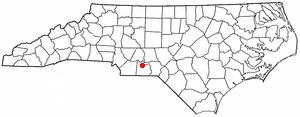
Ansonville is a town in Anson County, North Carolina, United States. The population was 421 at the 2020 census.

<span class="mw-page-title-main">Clarks Green, Pennsylvania</span> Borough in Pennsylvania, United States

Clarks Green is a borough in Lackawanna County, Pennsylvania. It is part of Northeastern Pennsylvania. The population was 1,529 at the 2020 census.

<span class="mw-page-title-main">Eastover, South Carolina</span> Town in South Carolina, United States

Eastover is a town in Richland County, South Carolina, United States. The population was 813 at the 2010 census, down from 830 in 2000. It is part of the Columbia, South Carolina, Metropolitan Statistical Area.

<span class="mw-page-title-main">Crane, Texas</span> City in Texas, United States

Crane is a city in and the county seat of Crane County, Texas, United States. Its population is about 3,680 as of 2018. An oil boomtown since the 1920s, Crane is still in the center of a prominent oil-producing region. It is the only significant town in sparsely populated Crane County, and contains the only post office in the county.

<span class="mw-page-title-main">Lumberport, West Virginia</span> Town in West Virginia, United States

Lumberport is a town in Harrison County, located in northern West Virginia, United States. The population was 720 at the 2020 census.

<span class="mw-page-title-main">Henderson, West Virginia</span> Unincorporated Town in West Virginia, United States

Henderson is an unincorporated community and former town in Mason County, West Virginia, United States, at the confluence of the Ohio and Kanawha Rivers. The population was 231 at the 2020 census. It is part of the Point Pleasant, WV–OH Micropolitan Statistical Area. The town was incorporated in 1893 and named for Samuel Bruce Henderson, who owned the townsite at the time. The town was unincorporated following a public hearing on August 11, 2022.

References

  1. "2020 U.S. Gazetteer Files". United States Census Bureau. Retrieved October 31, 2021.
  2. "U.S. Census website". United States Census Bureau . Retrieved 2008-01-31.
  3. "US Board on Geographic Names". United States Geological Survey. 2007-10-25. Retrieved 2008-01-31.
  4. "2010 Census Interactive Population Search". Archived from the original on 2012-09-01. Retrieved 2012-03-26.
  5. "US Gazetteer files: 2010, 2000, and 1990". United States Census Bureau. 2011-02-12. Retrieved 2011-04-23.
  6. "Census of Population and Housing". Census.gov. Retrieved June 4, 2015.
  7. "Explore Census Data". data.census.gov. Retrieved 2022-03-05.