
The Province of the Cape of Good Hope, commonly referred to as the Cape Province and colloquially as The Cape, was a province in the Union of South Africa and subsequently the Republic of South Africa. It encompassed the old Cape Colony, and had Cape Town as its capital. Following the end of the Apartheid era, the Cape Province was split up to form the new Eastern Cape, Northern Cape and Western Cape provinces, along with part of the North West.

A mantle is an ecclesiastical garment in the form of a very full cape that extends to the floor, joined at the neck, that is worn over the outer garments.

Cobra is the common name of various elapid snakes, most of which belonging to the genus Naja.

The purple heron is a wide-ranging species of wading bird in the heron family, Ardeidae. The scientific name comes from Latin ardea "heron", and purpureus, "coloured purple". It breeds in Africa, central and southern Europe, and southern and eastern Asia. The Western Palearctic populations migrate between breeding and wintering habitats whereas the African and tropical-Asian populations are primarily sedentary, except for occasional dispersive movements.

Bourne is a town in Barnstable County, Massachusetts, United States. The population was 19,754 at the 2010 census.

Makhanda is a town of about 70,000 people in the Eastern Cape province of South Africa. It is situated about 110 kilometres (70 mi) northeast of Port Elizabeth and 130 kilometres (80 mi) southwest of East London. Makhanda is the largest town in the Makana Local Municipality, and the seat of the municipal council. It also hosts Rhodes University, the Eastern Cape Division of the High Court, The South African Library for the Blind (SALB) and a diocese of the Anglican Church of Southern Africa and 6 South African Infantry Battalion. The name change to Makhanda was officially gazetted on 29 June 2018.

Ngcobo is a town in the Eastern Cape province of South Africa.

The Diocese of Cape Town is a diocese of the Anglican Church of Southern Africa (ACSA) which presently covers central Cape Town, some of its suburbs and the island of Tristan da Cunha, though in the past it has covered a much larger territory. The Ordinary of the diocese is Archbishop of Cape Town and ex officio Primate and Metropolitan of the ACSA. His seat is St. George's Cathedral in Cape Town.
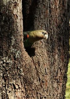
The Cape parrot or Levaillant's parrot is a large, temperate forest dwelling parrot of the genus Poicephalus endemic to South Africa. It was formerly grouped as a subspecies along with the savanna-dwelling brown-necked parrot(P. fuscicollis fuscicollis) and grey-headed parrot(P. f. suahelicus), but is now considered a distinct species.

The karoo korhaan, also known as karoo bustard, is a species of bird in the bustard family, Otididae, from Southern Africa. The species is sometimes placed in the genus Heterotetrax. It is the sister-species to Rüppell's korhaan, and the two species are sometimes considered conspecific. There are two subspecies, the nominate race, from south-eastern South Africa, and E. v. namaqua, from north-eastern South Africa and southern Namibia.
Leonard Michael Anthony "Len"/"Lenny The Lion" Killeen was a South African basketball player, rugby union, and rugby league footballer of the 1960s and 1970s.
Naude's Neck Pass, in the Eastern Cape, South Africa, connects Maclear to Rhodes. With its summit at 2,587 m above sea level, the pass is the second highest dirt road in South Africa. This pass is based on the route taken by the intrepid Naudé brothers in the 1890s.
Moordenaarsnek Pass, or just Moordenaarsnek, is situated in the Eastern Cape, province of South Africa, on the regional road R56, between Mount Fletcher and Maclear, Eastern Cape.
Witnek Pass,, is situated in the Eastern Cape, province of South Africa, on the road between Nieu-Bethesda and Cradock, Eastern Cape.
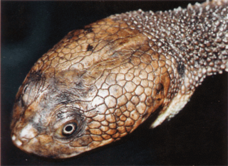
Chelodina canni, known as Cann's snake-necked turtle, is an Australian species found in the northern and northeastern parts of the continent. It has a narrow zone of hybridization with its related species the eastern snake-necked turtle, Chelodina longicollis. For many years this species was assumed to be the same species as Chelodina novaeguineae from New Guinea, however recently it has been shown that these two species differ both morphologically and genetically. Hence it was separated and described as a unique species in 2002.

Engcobo Local Municipality is an administrative area in the Chris Hani District of the Eastern Cape in South Africa. Ngcobo is an isiXhosa name for a sweet grass found in the area.

Thembuland, Afrikaans: Temboeland, is a natural region in the Eastern Cape province of South Africa. Its territory is the traditional region of the Thembu people, one of the sub-groups of the Xhosa nation.
All Saints Hospital is a Provincial government funded hospital in Ngcobo, Eastern Cape in South Africa. Situated about 5km between Ngcobo and Umtata, the hospital serves the entire Ngcobo and some of the Cofimvaba community of over 148 000 people.


