R61 (South Africa)

Last updated

SA road R61.svg
Provincial route R61
Map of the R61 (South Africa).svg
Route information
Maintained by WCDTPW, SANRAL and ECDRPW
Length1,061 km (659 mi)
Major junctions
West endSA road N1 jct.svgSA road N12 jct.svg N1  / N12 in Beaufort West
Major intersectionsSA road N9 jct.svg N9 in Aberdeen
SA road R63.svg R63 in Graaff-Reinet
SA road N9 jct.svg N9 near Bethesdaweg
SA road N10 jct.svg N10 in Cradock
SA road R67.svg R67 in Komani
SA road N6 jct.svg N6 in Komani
SA road N6 jct.svg N6 southeast of Komani
SA road R58.svg R58 in Ngcobo
SA road N2 jct.svg N2 in Mthatha
East endSA road N2 jct.svg N2 in Port Shepstone
Location
Country South Africa
Major cities
Highway system
SA road R60.svg R60 SA road R62.svg R62

The R61 is a long provincial route in South Africa that connects Beaufort West with Port Shepstone via Graaff-Reinet, Komani (previously Queenstown), Mthatha and Port Edward. [1]

Contents

The R61 is co-signed with the N9 for 103 kilometres from Aberdeen through Graaff-Reinet to Bethesdaweg, and with the N6 for 18 kilometres near Queenstown. [1]

Route

KwaZulu-Natal

The R61 begins in Port Shepstone at an interchange with the N2 highway from Durban (at the Oribi Toll Plaza). As the N2 leaves the freeway at an off-ramp and becomes the road westwards towards Harding and Kokstad, the R61 takes over as the freeway south-south-west through the KwaZulu-Natal South Coast. As the 1st section is maintained by SANRAL, the R61 is a toll road for 22 km from the N2 Interchange, through Shelly Beach, Margate and Ramsgate, up to Southbroom. At Southbroom, it stops being both a toll road and a highway. From Port Shepstone to Southbroom, the R61 is followed by the R620 route.

From Southbroom the R61 resumes south-south-west for 25 kilometres to Port Edward. Just after Port Edward, the R61 leaves the KwaZulu-Natal Province and crosses the Mtamvuna River via the C. H. Mitchell Bridge into the Eastern Cape Province.

Eastern Cape

From the provincial boundary (Mtamvuna River), the R61 heads north-west for 50 km to the town of Bizana, which it bypasses to the south. From Bizana, the R61 continues westwards for 25 kilometres to reach a junction with the R394 road, where the R61 turns southwards and heads for 70 kilometres, through Flagstaff, to the town of Lusikisiki. It continues southwards for 40 kilometres to cross the Mzimvubu River and reach a junction just north of the town of Port St. Johns. It bends to the west and heads 87 kilometres, bypassing Libode, to the city of Mthatha, where it crosses the Mthatha River and meets the N2 national route again in the city centre.

From Mthatha, the R61 heads westwards for 83 kilometres as the All Saints Neck Pass, bypassing Mthatha Airport, to the town of Ngcobo, where it meets the eastern terminus of the R58 road and the R61 turns to the south-south-west. After 45 kilometres, at the R409 intersection near Tsomo, the R61 turns to the west and heads for 80 kilometres, through Cofimvaba and Qamata, to reach a t-junction with the N6 national route. The R61 joins the N6 and they become one road north-west for 18 kilometres into the town of Komani (formerly Queenstown) as Louis Botha Road and Cathcart Street. At the roundabout with Barrable Street in Komani, the R61 becomes its own road west-south-west and after almost 2 kilometres, it meets the northern terminus of the R67 road at a roundabout. The R61 heads westwards for 136 kilometres, through Tarkastad, to the town of Cradock, where it meets the N10 national route. The R61 & N10 are one road northwards through the city centre of Cradock, continuing by a left turn (Commissioner Street), a right turn (JA Calata Street) and another left turn, to cross the Great Fish River.

The R61 and the N10 remain as one road for another 4.5 km west-north-west, before the R61 becomes its own road westwards. The R61 continues for 85 kilometres as the Wapadsberg Pass to reach a junction with the N9 national route south-east of Bethesdaweg. They are one road southwards for 46 km into the town of Graaff-Reinet, where they meet and are co-signed for a few kilometres with the R63 route, crossing the Sundays River. From Graaff-Reinet, the R61 & N9 remain as one road west-south-west for 55 km up to the town of Aberdeen. At the 4-way-junction with Hoop Street (R338), the R61 stops co-signing with the N9 and becomes the road westwards from this junction.

From Aberdeen, the R61 heads westwards for 148 kilometres, crossing into the Western Cape Province, to enter the town of Beaufort West and reach its western terminus at a junction with the N1 and N12 national route co-signage.

Wild Coast Highway

There are plans to give the first section of the R61, from its starting junction with the N2 in Port Shepstone to its other junction with the N2 in Mthatha, to the N2 national route. [2] [3] [4] The project was initially scheduled for completion in 2024. [5] Together with the current N2 from Mthatha to East London, this route will be named the "Wild Coast Toll Route".

While it will take over most of the R61's route, this new Wild Coast Highway of the N2 will be realigned in some places. This new Wild Coast Highway will provide a shorter and more direct route from Lusikisiki to Port Edward (via the Mtentu Bridge and Msikaba Bridge) while the current R61 passes through Flagstaff and Bizana on the route between those two towns (it will be 69 km shorter than the current R61). [3] [4] This new shortcut between Port Edward and Lusikisiki will have a tollgate constructed while there will also be a tollgate constructed on the stretch from Lusikisiki to Mthatha, just outside of Port St Johns. [3] [4] The overall distance between Port Shepstone and Mthatha will be 85 km shorter than the current N2. [3] [4]

Once the N2 Wild Coast Toll Route is complete, the existing 320 kilometre section of the R61 from Port Shepstone via Port Edward, Bizana, Flagstaff, and Lusikisiki to Mthatha will no-longer be designated as the R61. [3] [4]

Board signs indicating the N2 to Port Shepstone and Port Edward N2 Margate.jpg
Board signs indicating the N2 to Port Shepstone and Port Edward

As of 2021, the road classification numbers on the board signs on the R61 between Port Shepstone and Port Edward have already been changed to signs indicating the N2 as part of the Wild Coast Highway Project, indicating that the freeway from the Oribi Toll Plaza in Port Shepstone southwards will no-longer be designated as the R61. [6] Also, some of the Eastern Cape sections of the new Wild Coast Highway are being constructed as of 2021. [7]

See also

Related Research Articles

<span class="mw-page-title-main">Margate, South Africa</span> Resort town in KwaZulu-Natal, South Africa

Margate is a coastal resort town in the KwaZulu-Natal province, about 20 kilometres south-west of Port Shepstone and 127 kilometres south-west of Durban. The river which flows into the sea at Margate is called "Nkhongweni" (place of entreaty) as the original inhabitants of the area were reputed to be so mean resulting in travellers begging for hospitality.

<span class="mw-page-title-main">Port Shepstone</span> Coastal town in KwaZulu-Natal, South Africa

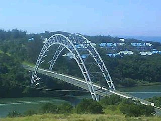
Port Shepstone is a large town situated on the mouth of the Mzimkhulu River, the largest river on the KwaZulu-Natal South Coast of South Africa. It is located halfway between Hibberdene and Margate and is positioned 120 km south of Durban. It serves as the administrative, educational, industrial and commercial centre for southern Natal.

<span class="mw-page-title-main">Port Edward, South Africa</span> Seaside town in KwaZulu-Natal, South Africa

Port Edward is a small resort town situated on the south coast of KwaZulu-Natal in South Africa and lies on the border between KwaZulu-Natal and the Eastern Cape. It is situated on the R61 road between Port Shepstone and Lusikisiki.

<span class="mw-page-title-main">Ramsgate, South Africa</span> Place in KwaZulu-Natal, South Africa

Ramsgate is a village on the south coast of KwaZulu-Natal in South Africa, just southwest of Margate. Ramsgate is located on the mouth of a river known by the Zulu name Bilanhlolo for the bubbles caused by strong currents making it look like the water is boiling. In 1922, there was only one person living there, Paul Buck, a painter and violin maker and he called the place Blue Lagoon.

<span class="mw-page-title-main">R56 (South Africa)</span> Road in South Africa

The R56 is a provincial route in South Africa that connects Middelburg with Pietermaritzburg via Molteno, Maclear and Kokstad. It is co-signed with the N2 between Kokstad and Stafford's Post for 39 kilometres.

<span class="mw-page-title-main">R63 (South Africa)</span> Road in South Africa

The R63 is a tarred provincial route in South Africa that connects Calvinia with Komga via Carnarvon, Victoria West, Graaff-Reinet, Somerset East and King William's Town. It is cosigned with the N10 between Eastpoort and Cookhouse for 24 kilometres.

<span class="mw-page-title-main">R67 (South Africa)</span>

The R67 is a provincial route in Eastern Cape, South Africa that connects Port Alfred with Komani via Grahamstown.

<span class="mw-page-title-main">R72 (South Africa)</span>

The R72 is a provincial route in Eastern Cape, South Africa that connects the N2 north-east of Gqeberha with East London via Port Alfred. It provides an alternative to the N2 for travel between Gqeberha and East London.

<span class="mw-page-title-main">R102 (South Africa)</span> Regional Route in South Africa

The R102 is a Regional Route in South Africa. It is the route designation for all old sections of the N2, thus it is a discontinuous road that resumes in areas where a new N2 has been constructed.

<span class="mw-page-title-main">R334 (South Africa)</span> Road in Nelson Mandela Bay, South Africa

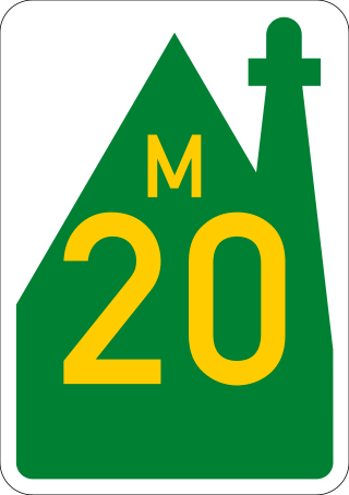
The R334 is a Regional Route in the Nelson Mandela Bay Metropolitan Municipality of South Africa that connects the N2 west of Port Elizabeth to the N2 at Coega north of Port Elizabeth via Uitenhage. The middle section of the route is also designated as the M20 metropolitan route.

<span class="mw-page-title-main">N2 (South Africa)</span> National road in South Africa

The N2 is a national route in South Africa that runs from Cape Town through George, Gqeberha, East London, Mthatha, Port Shepstone and Durban to Ermelo. It is the main highway along the Indian Ocean coast of the country. Its current length of 2,255 kilometres (1,401 mi) makes it the longest numbered route in South Africa.

<span class="mw-page-title-main">N6 (South Africa)</span> National road in South Africa

The N6 is a national route in South Africa that connects East London with Bloemfontein, via Komani and Maletswai. It runs roughly from north to south, connecting the N1 with the N2.

<span class="mw-page-title-main">N9 (South Africa)</span> National road in South Africa

The N9 is a national route in South Africa that connects George with the N1 at Colesberg, via Graaff-Reinet and Middelburg.

<span class="mw-page-title-main">N10 (South Africa)</span> National road in South Africa

The N10 is a national route in South Africa connecting Gqeberha on the Eastern Cape coast with the Namibian border at Nakop, via Cradock, De Aar and Upington.

Marburg is a settlement in the Ugu District Municipality in the KwaZulu-Natal province of South Africa, situated approximately 112 kilometres south-west of the city of Durban. Marburg was a Norwegian settlement given the name Marburg for a nearby German mission. The Norwegian founders played a significant role in the development of Marburg and Port Shepstone, which it forms part of today. The British colonial government gave the settlers a free voyage to South Africa and also houses and 100 acres of land. Marburg was the only successful Scandinavian settlement in South Africa.

<span class="mw-page-title-main">Lusikisiki</span> Place in Eastern Cape, South Africa

Lusikisiki is a town in the Ingquza Hill Local Municipality in the Eastern Cape Province, South Africa. The name is onomatopoeic, derived from the rustling sound of reeds in the wind, named by the local Xhosa people. Lusikisiki is 45 kilometres (28 mi) inland from and north of Port St Johns. The town is positioned along the R61 leading to Mthatha to the west and Port Shepstone to the north-east.

<span class="mw-page-title-main">Southbroom</span> Coastal village in KwaZulu-Natal, South Africa

Southbroom is a coastal village on the South Coast of the KwaZulu-Natal province of South Africa situated approximately halfway between Port Shepstone – 23 km (14 mi) and Port Edward – 18 km (11 mi).

The R620 is a regional route in KwaZulu-Natal, South Africa that connects Southbroom with Port Shepstone via Ramsgate, Margate, Uvongo and Shelly Beach.

<span class="mw-page-title-main">South Coast (KwaZulu-Natal)</span> Coastal region in KwaZulu-Natal, South Africa

KwaZulu-Natal South Coast is a region along the southern stretch of coastline of KwaZulu-Natal, South Africa, south of the coastal city of Durban.

References

  1. 1 2 "RDDA SOUTH AFRICAN NUMBERED ROUTE DESCRIPTION AND DESTINATION ANALYSIS". NATIONAL DEPARTMENT OF TRANSPORT. May 2012. Retrieved 25 March 2021.
  2. "@nuxtjs/Amp".
  3. 1 2 3 4 5 "Wild Coast toll road on track". DispatchLIVE. Retrieved 25 October 2020.
  4. 1 2 3 4 5 "N2 road project to continue". DispatchLIVE. Retrieved 25 October 2020.
  5. "Wild Coast Road project takes in highest bridge in Africa". The South African. 5 September 2020. Retrieved 25 October 2020.
  6. "Google Maps". Google Maps. Retrieved 28 September 2023.
  7. Langa, Lungi (13 September 2021). "OUR BURNING PLANET: Sparks fly at meeting with rural community over proposed N2 Wild Coast toll road". Daily Maverick. Retrieved 3 August 2022.