Graaff-Reinet

Last updated

Graaff-Reinet
RSA Graaff-Reinet01.jpg
View of Graaff-Reinet
Town Hall Graaff Reinet-001.jpg
Town Hall
12 1072m - Valley of Desolation.jpg
Valley of Desolation
Karoo Landscape, Nqweba, Eastern Cape, South Africa (20324198338).jpg
Fields near Graaff-Reinet
Graaff-Reinet House Museum ... (Photo JC PLE) (52652872839).jpg
Graaff-Reinet Museum
Graaff-Reinet Coat of Arms.jpg
South Africa Eastern Cape location map.svg
Red pog.svg
Graaff-Reinet
South Africa adm location map.svg
Red pog.svg
Graaff-Reinet
Africa location map.svg
Red pog.svg
Graaff-Reinet
Coordinates: 32°15′08″S24°32′26″E / 32.25222°S 24.54056°E / -32.25222; 24.54056
Country South Africa
Province Eastern Cape
District Sarah Baartman
Municipality Dr Beyers Naudé
Established1786 [1]
Area
[2]
  Total203.62 km2 (78.62 sq mi)
Elevation
750 m (2,460 ft)
Population
 (2011) [2]
  Total35,672
  Density180/km2 (450/sq mi)
Racial makeup (2011)
[2]
   Coloured 62.18%
   Black African 28.19%
   White 8.74%
   Indian/Asian 0.47%
  Other0.42%
First languages (2011)
[2]
   Afrikaans 71.83%
   IsiXhosa 17.89%
   English 3.37%
  Other6.91%
Time zone UTC+2 (SAST)
Postal code (street)
6286, 6280, 6281
Area code 049

Graaff-Reinet is a town in the Eastern Cape Province of South Africa. It is the oldest town in the province and the fourth oldest town in South Africa, after Cape Town, Stellenbosch, Simon's Town, Paarl and Swellendam. [3] [4] The town was the centre of a short-lived republic in the late 18th century. [5] The town was a starting point for Great Trek groups led by Gerrit Maritz and Piet Retief and furnished large numbers of the Voortrekkers in 1835–1842. [5]

Contents

Graaff-Reinet is home to more national monuments than any other town or city in South Africa. [6] It is also known for being a flourishing market for agricultural produce, noted for its mohair industry, and sheep and ostrich farming.

History

Boer republic of Graaff-Reinet (blue) and other Dutch territories around 1795 Kapkolonie 1795.jpg
Boer republic of Graaff-Reinet (blue) and other Dutch territories around 1795

Graaff-Reinet was established by the Dutch East India Company in 1786, after Cape Town in 1652, Stellenbosch in 1679, Paarl in 1687 and Swellendam in 1745. The town is named after then-governor of the Cape Colony, Cornelis Jacob van de Graaff, and his wife. The town was originally established as a trading post to expand trading inland from the Cape Colony. [5]

In 1795, the town's burghers, who were annoyed by company taxation, proclaimed themselves to be the independent "Colony of Graaff-Reinet". The burghers then requested guardianship from the government of the Netherlands. Similar action was subsequently taken by the burghers of Swellendam. [5] Before the authorities at Cape Town could take decisive measures against the rebels, they were compelled to capitulate to the British who had invaded and occupied the Cape. [5]

In January 1799, Marthinus Prinsloo, a leader of the 1795 independence movement, rebelled again but surrendered the following April. Prinsloo and nineteen others were imprisoned in the Cape Town castle. After trial, Prinsloo and another commandant were sentenced to death. Other conspirators were sentenced to exile. The sentences were not carried out and the prisoners were released in March 1803, on the retrocession of the Cape to the Netherlands.

In 1801, there was another revolt in Graaff Reinet, but due to the measures of General Francis Dundas, the acting governor of the Cape Colony, peace was soon restored. In February 1803, due to the 1802 signing of the Treaty of Amiens, the British returned the Cape Colony to the Netherlands, then named the Batavian Republic. [5]

On 13 August 1814 the Cape Colony was formally ceded to Britain by a convention under which Dutch vessels were entitled to resort freely to the Cape of Good Hope for the purposes of refreshment and repairs. Britain agreed on 13 August 1814 to pay five million sterling to the United Netherlands for the Dutch possession at the Cape.

The Cape Colony received a degree of independence in 1872 when "Responsible Government" was declared in South Africa. In 1877, the government of Prime Minister John Molteno began construction of the railway line connecting Graaff-Reinet to Port Elizabeth on the coast. This railway was officially opened on 26 August 1879. [7]

Graaff Reinet became the centre of British military operations for the Eastern Cape during the Second Boer War. In 1901, a number of captured Boer rebels were tried in the town for crimes ranging from high treason, murder, attempted murder, arson and robbery. Nine were sentenced to death, with eight of these being executed by firing squad on the outskirts of the town, while the ninth sentence was carried out in Colesberg. A monument stands in the town to commemorate these fallen Boers. [8]

Geography

The town lies 750 metres (2,460 ft) above sea level and is built on the banks of the Sundays River, which rises a little further north on the southern slopes of the Sneeuberge, and splits into several channels here.

The town is home to a number of tourist attractions, including the Dutch Reformed church in the town, which is a prominent stone building with seating to accommodate 1,500 people. The building is influenced by the architecture of Salisbury Cathedral in England. [9] The town is also home to tourist sites such as The Valley of Desolation, Camdeboo National Park and the Reinet House Museum, a Cape Dutch building, formerly the Dutch Reformed Church parsonage.

Demographics

In the South African National Census of 2011, the population of Graaff-Reinet and the township of uMasizakhe was recorded as 35,672, which included 8,393 households. 62.2% of these residents described themselves as "Coloured" an identity that Khoi communities were coerced into accepting, 28.2% as "Black African", and 8.7% as "White". The dominant language was Afrikaans, which was the first language of 76.0% of the population. 18.9% spoke Xhosa, and 3.6% spoke English. [2]

Dutch Reformed Church
Graaff-Reinet GR3.jpg
The Dutch Reformed Church ( Grotekerk ) in Graaff-Reinet
Graff-Reinet Dutch Reform Church.jpg
An aerial view of Graaff-Reinet's Dutch Reformed Church

Notable people

The Drostdy Hotel Graaff Reinet.jpg
The Drostdy Hotel

Great Trek and Boer Republics

Politics

Sciences

Sports

Literature and the Arts

Economics

Academics

Other

Coats of arms

Graaff-Reinet Coat of Arms.jpg

Drostdy

In 1804, when the Cape Colony was ruled by the Batavian Republic, the government assigned armorial seals to each of the drostdyen, i.e. administrative districts. Graaff Reinet was given the arms of its founder, Cornelis Jacob van de Graaff, namely a silver shield displaying two black stripes with embattled edges, and a golden canton bearing a double-headed black eagle. An anchor was placed behind the shield. [19] The British authorities discontinued the drostdy seals in 1814, and replaced them with the royal coat of arms. [20]

Municipal (1)

In September 1911, the Graaff Reinet municipal council adopted the Van de Graaff arms, complete with crest (a double-headed black eagle), supporters (two black eagles) and motto (Dieu mon conduise). [21] [22]

Municipal (2)

The coat of arms was re-designed in the 1980s, and registered at the Bureau of Heraldry in May 1979. [23]

The arms were now: Argent, two bars embattled counter-embattled Gules, on a canton Sable an anchor erect Or (i.e. the bars were changed from black to red, and the canton to a gold anchor on a black background). The crest was differenced by placing a golden anchor on the eagle's breast. The supporters and motto remained the same.

Divisional council

The divisional council, i.e. the local authority for the rural areas outside the town, assumed its own coat of arms, had it granted by the provincial administrator in July 1966 [24] and registered it at the Bureau of Heraldry in January 1969. [23]

The arms were: Argent, on a chevron Vert. a pair of compasses expanded Argent, in base a spade erect Sable, on a chief embattled Sable a merino ram's head caboshed Or. In layman's terms, a silver shield displaying, from top to bottom, a golden merino ram's head on a black stripe with an embattled edge, a pair of silver compasses on a green chevron, and an upright black spade.

The crest was a double-headed black eagle, and the motto was Monemus et minimus.

Further reading

See also

Related Research Articles

<span class="mw-page-title-main">Boers</span> Descendants of Afrikaners beyond the Cape Colony frontier

Boers are the descendants of the proto Afrikaans-speaking Free Burghers of the eastern Cape frontier in Southern Africa during the 17th, 18th, and 19th centuries. From 1652 to 1795, the Dutch East India Company controlled Dutch Cape Colony, but the United Kingdom incorporated it into the British Empire in 1806. The name of the group is derived from Trekboer then later "boer", which means "farmer" in Dutch and Afrikaans.

<span class="mw-page-title-main">Cape Province</span> Former province of South Africa

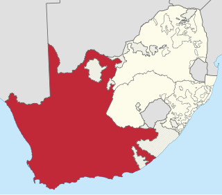
The Province of the Cape of Good Hope, commonly referred to as the Cape Province and colloquially as The Cape, was a province in the Union of South Africa and subsequently the Republic of South Africa. It encompassed the old Cape Colony, as well as Walvis Bay, and had Cape Town as its capital. In 1994, the Cape Province was divided into the new Eastern Cape, Northern Cape and Western Cape provinces, along with part of the North West.

<span class="mw-page-title-main">Great Trek</span> 1836–1852 Boer migrations away from the British Cape Colony

The Great Trek was a northward migration of Dutch-speaking settlers who travelled by wagon trains from the Cape Colony into the interior of modern South Africa from 1836 onwards, seeking to live beyond the Cape's British colonial administration. The Great Trek resulted from the culmination of tensions between rural descendants of the Cape's original European settlers, known collectively as Boers, and the British Empire. It was also reflective of an increasingly common trend among individual Boer communities to pursue an isolationist and semi-nomadic lifestyle away from the developing administrative complexities in Cape Town. Boers who took part in the Great Trek identified themselves as voortrekkers, meaning "pioneers", "pathfinders" in Dutch and Afrikaans.

<span class="mw-page-title-main">Boer republics</span> Former countries in southern Africa

The Boer republics were independent, self-governing republics formed by Dutch-speaking inhabitants of the Cape Colony and their descendants. The founders – variously named Trekboers, Boers, and Voortrekkers – settled mainly in the middle, northern, north-eastern and eastern parts of present-day South Africa. Two of the Boer republics achieved international recognition and complete independence: the South African Republic and the Orange Free State. The republics did not provide for the separation of church and state, initially allowing only the Dutch Reformed Church, and later also other Protestant churches in the Calvinist tradition. The republics came to an end after the Second Boer War of 1899–1902, which resulted in British annexation and later incorporation of their lands into the Union of South Africa.

<span class="mw-page-title-main">Andries Pretorius</span> South African politician (1798–1853)

Andries Wilhelmus Jacobus Pretorius was a leader of the Boers who was instrumental in the creation of the South African Republic, as well as the earlier but short-lived Natalia Republic, in present-day South Africa. The large city of Pretoria, executive capital of South Africa, is named after him.

<span class="mw-page-title-main">Trekboers</span> Historical group of pastoralists in Southern Africa

The Trekboers were nomadic pastoralists descended from European colonists on the frontiers of the Dutch Cape Colony in Southern Africa. The Trekboers began migrating into the interior from the areas surrounding what is now Cape Town, such as Paarl, Stellenbosch, and Franschhoek, during the late 17th century and throughout the 18th century.

<span class="mw-page-title-main">Uitenhage</span> Place in Eastern Cape, South Africa

Uitenhage, officially renamed Kariega, is a South African town in the Eastern Cape Province. It is well known for the Volkswagen factory located there, which is the biggest car factory on the African continent. Along with the city of Port Elizabeth and the small town of Despatch, it forms the Nelson Mandela Bay Metropolitan Municipality.

The following lists events that happened during the 1790s in South Africa.

The following lists events that happened during the 1780s in South Africa.

<span class="mw-page-title-main">Aberdeen, South Africa</span> Place in Eastern Cape, South Africa

Aberdeen is a small town in the Sarah Baartman District Municipality of the Eastern Cape province of South Africa. With its numerous examples of Victorian architecture, it is one of the architectural conservation areas of the Karoo.

<span class="mw-page-title-main">Jacobus Nicolaas Boshoff</span> South African Boer statesman

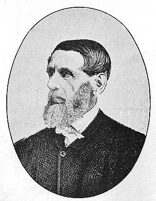
Jacobus Nicolaas Boshof was a South African (Boer) statesman, a late-arriving member of the Voortrekker movement, and the second state president of the Orange Free State, in office from 1855 to 1859.

<span class="mw-page-title-main">Uys</span> Surname list

Uys is the surname of a family that played a significant role in South African history during the nineteenth century and made distinguished contributions to South African culture, politics and sports during the course of the twentieth.

<span class="mw-page-title-main">Andries Stockenström</span>

Sir Andries Stockenström, 1st Baronet, was lieutenant governor of British Kaffraria from 13 September 1836 to 9 August 1838.

Maria Elizabeth Rothmann, penname M.E.R. was an Afrikaans writer, and co-founder of the Voortrekkers youth movement. Her unique contribution to Afrikaans literature was an ethical didactic, cultural historic review of a bygone Afrikaans society.

<span class="mw-page-title-main">Abraham Faure</span>

Abraham Faure was a clergyman and author from Cape Colony, part of what later became South Africa.

<span class="mw-page-title-main">1854 Cape Colony parliamentary election</span>

The first election for the Parliament of the Cape of Good Hope was held in 1854. There were no clear party lines, however many representatives for Eastern electoral districts subscribed to a common programme which emphasised separation from the Cape Colony or moving the seat of colonial government eastward, a vagrancy law, or increasing the property qualification part of the franchise.

Olof Godlieb de Wet (1739–1811) was a South African high-ranking official in the Dutch East India Company and co-founder of the Freemasons in South Africa.

<span class="mw-page-title-main">Dutch Reformed Church, Burgersdorp</span> Church in Burgersdorp, South Africa

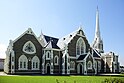
The Dutch Reformed Church in Burgersdorp is a congregation of the Dutch Reformed Church in the Synod of Eastern Cape in South Africa. It is the eighth oldest congregation in this Synod and was founded in 1846, 54 years after Graaff-Reinet. In the entire NG Church it was the 34th foundation, all of which except Pietermaritzburg (1839) and Potchefstroom (1842) were located in the single Cape Colony. In 2016, the congregation had 510 professing and 135 baptized members. Of the professing members, only 200 were under 50, while 140 of the 510 lived locally. On August 17, 2020, the church was damaged by a fire.

References

  1. Robson, Linda Gillian (2011). "Annexure A" (PDF). The Royal Engineers and settlement planning in the Cape Colony 1806–1872: Approach, methodology and impact (PhD thesis). University of Pretoria. pp. xlv–lii. hdl:2263/26503.
  2. 1 2 3 4 5 Sum of the main places Graaff Reinet and uMasizakhe from Census 2011.
  3. Floyd, TB (1960). "What are the Oldest Towns in South Africa?".
  4. "What are the Oldest Towns in South Africa?". 2003.
  5. 1 2 3 4 5 6 Wikisource-logo.svg One or more of the preceding sentences incorporates text from a publication now in the public domain :  Chisholm, Hugh, ed. (1911). "Graaff Reinet". Encyclopædia Britannica . Vol. 12 (11th ed.). Cambridge University Press. p. 306.
  6. "Graaff-Reinet City website".
  7. Burman, Jose (1984), Early Railways at the Cape. Cape Town: Human & Rousseau, p.68. ISBN   0-7981-1760-5
  8. Innocent Bloodauthor=Graham Jooste, Roger Webster. New Africa Books. 2002. p. 50. ISBN   0-86486-532-5 . Retrieved 12 October 2008.
  9. "NG Grootkerk History". Archived from the original on 4 September 2014. Retrieved 13 June 2014.
  10. Grobler, Jack. "The Retief Massacre of 6 February 1838 revisited" (PDF). repository.up.ac.za.
  11. "About Potchefstroom – History". Potchefstroom.co.za. 11 October 2004.
  12. "Genealogie en Geselsgroep – Jeffreysbaai / Jeffreys Bay Genealogy Interest Group: Commandant Lourens Jacobus (Louw) Wepener". 2015.
  13. https://kormorant.co.za/2009/11Nov/26Nov/Pretorius.htm%5B%5D
  14. "Beyers Naudé." African National Congress. Retrieved on 21 August 2008.
  15. "Matthew Goniwe". SA History. Retrieved 23 February 2015.
  16. "Memorial to Johannes J. Brummer 1921–2005" (PDF). The Geological Society of America.
  17. Watts, G (12 December 2015). "Aubrey Sheiham". Lancet. 386 (10011): 2388. doi:10.1016/s0140-6736(15)01204-0. PMID   26709401. S2CID   46037473.
  18. 1 2 Ets-Hokin, Gabe (10 June 2007). "CW 5Q: Pierre Terblanche". Cycle World.
  19. Pama, C. (1965) Lions and Virgins.
  20. Cape Town Gazette 418 (15 January 1814).
  21. Western Cape Archives : Graaff Reinet Municipal Minutes (22 September 1911).
  22. The arms were depicted on a cigarette card issued in 1931.
  23. 1 2 http://www.national.archsrch.gov.za%5B%5D
  24. Cape of Good Hope Official Gazette 3354 (8 July 1966).