Swellendam

Last updated

Swellendam
Swellendam view.jpg
Dutch Reformed Church Swellendam2.JPG
Schoone-Oordt-Country-House-Hotel-Swellendam-South-Africa-1.jpg
Old Drostdy, Swellendam.JPG
Historical Village, Swellendam. 07.jpg
From the top, Swellendam with the Clock Peaks (1710m) of the Langeberg in the background. Middle left, Dutch Reformed Church. Middle right, a historic Cape Georgian style home. Bottom left, Old Drostdy historic home and a good example of the Cape Dutch architectural style in the area. Bottom right, the restored historical village area of Swellendam.
Crest of Swellendam.png
South Africa Western Cape location map.svg
Red pog.svg
Swellendam
South Africa adm location map.svg
Red pog.svg
Swellendam
Africa location map.svg
Red pog.svg
Swellendam
Coordinates: 34°01′23″S20°26′24″E / 34.02306°S 20.44000°E / -34.02306; 20.44000
Country South Africa
Province Western Cape
District Overberg
Municipality Swellendam
Established1745 [1]
Named for Hendrik Swellengrebel and his wife, Helena Ten Damme
Area
[2]
  Total19.68 km2 (7.60 sq mi)
Population
 (2011) [2]
  Total4,676
  Density240/km2 (620/sq mi)
Racial makeup (2011)
[2]
   White 69.31%
   Coloured 22.54%
   Black African 6.67%
   Indian/Asian 0.34%
  Other1.13%
First languages (2011)
[2]
   Afrikaans 82.84%
   English 13.77%
   Xhosa 0.88%
   Sotho 0.31%
  Other2.2%
Time zone UTC+2 (SAST)
Postal code (street)
6740
PO box
6740
Area code 028

Swellendam is the third oldest town [3] [4] in South Africa (after Cape Town and Stellenbosch), a town with 17,537 inhabitants situated in the Western Cape province. The town has over 50 provincial heritage sites, most of them buildings of Cape Dutch architecture. Swellendam is situated on the N2, approximately 220 km (140 miles) from both Cape Town and George.

Contents

History

Boer Republic of Swellendam (red) and other Dutch territories around 1795 Kapkolonie 1795.jpg
Boer Republic of Swellendam (red) and other Dutch territories around 1795

Early travellers and explorers who visited the Cape in the 16th century traded with the Khoikhoi people who lived on these shores and in the interior. When the Dutch East India Company established a replenishment station at the Cape in 1652, trade continued inland as far as Swellendam.

In 1743, Swellendam was declared a magisterial district, the third-oldest in South Africa, and was named after Governor Hendrik Swellengrebel, the first South African born Governor, and his wife, Helena Ten Damme. This outlying settlement soon became a gateway to the interior, and was visited by many famous explorers and travellers including François Le Vaillant (1781), Lady Anne Barnard (1798), William John Burchell (1815), and Thomas William Bowler (1860). In time, a village was established beyond the Drostdy, where artisans including numerous wainwrights and traders settled. Swellendam was the last Dutch outpost on the eastern frontier, and provided useful crafts services in the region.

By 1795, maladministration and inadequacies of the Dutch East India Company caused the burghers of Swellendam to revolt, and on 17 June 1795, they declared themselves a Republic. Hermanus Steyn was appointed as President of the Republic of Swellendam. The burghers of Swellendam started to call themselves "national burghers", after the style of the French Revolution. The Republic was short-lived, and was ended on 4 November 1795, when the Cape was occupied by the Kingdom of Great Britain. [5] With the arrival of British settlers in the early 19th century, the Overberg boomed, and Swellendam was soon the heart of the mercantile empire of Barry and Nephews, created by Joseph Barry, which dominated trade in the area up until 1870. [6] The Breede River is the longest navigable river in South Africa [7] and ships sailed 35 km (20 miles) up river to Malgas to unload and load merchandise.

By the middle of the 19th century, the eastern districts had been colonised by the British settlers and Swellendam had grown in size. The town served as a useful refreshment station on the long, slow journey up the coast. Today Swellendam remains an agricultural area, and contains multiple historic buildings. The first known sketch of Swellendam was of the Drostdy, by Johannes Schumacher in 1776, when he accompanied the son of Governor Swellengrebel to the town. Today the Drostdy forms part of a museum complex that consist of several heritage sites, namely the Drostdy, the old Gaol, and Mayville.

The 1936 census recorded a total population 3,784 residents. [8]

Famous pioneer families

Some of the famous families that settled in the region and have since lived there are the Barry family, the Moodies from Scotland, the Steyns (Including The President of the Republic of Swellendam) the Streicher family, the Van Eeden family, the Rothmann family, the Tomlinson family and the Dunn family. Both Johannes Brand and Francis Reitz spent some of their childhood in the same Cape Dutch house in Swellendam. Both became presidents of the Orange Free State .

Climate

The region has a predominantly Mediterranean climate. There are long summer days in January and February. During February and March, summer draws to a close, with prevailing South Easter winds. April and May are autumnal months, with milder days and occasional showers. June and July bring the Cape winter, with mild weather, rain and possible snow on the mountain tops. August and September are the start of spring.

Climate data for Swellendam
MonthJanFebMarAprMayJunJulAugSepOctNovDecYear
Mean daily maximum °C (°F)30.7
(87.3)
30.5
(86.9)
28.3
(82.9)
25.4
(77.7)
22.4
(72.3)
20.6
(69.1)
19.5
(67.1)
20.6
(69.1)
21.9
(71.4)
24.4
(75.9)
26.9
(80.4)
29.1
(84.4)
25.0
(77.0)
Mean daily minimum °C (°F)16.7
(62.1)
17.1
(62.8)
15.6
(60.1)
12.3
(54.1)
8.9
(48.0)
6.4
(43.5)
5.8
(42.4)
7.0
(44.6)
8.8
(47.8)
11.6
(52.9)
13.8
(56.8)
15.3
(59.5)
11.6
(52.9)
Average precipitation mm (inches)39
(1.5)
46
(1.8)
50
(2.0)
66
(2.6)
52
(2.0)
44
(1.7)
46
(1.8)
60
(2.4)
38
(1.5)
51
(2.0)
40
(1.6)
32
(1.3)
564
(22.2)
Source: Climate-Data.org [9]

Fauna and flora

The Grootvadersbosch Nature Reserve against the Langeberg Mountains Grootvadersbosch Nature Reserve PICT3774.JPG
The Grootvadersbosch Nature Reserve against the Langeberg Mountains

Three nature reserves are situated near Swellendam, Marloth Nature Reserve, Sanbona Wildlife Reserve and Bontebok National Park. Bontebok National Park is where the rare bontebok was protected when it was close to extinction. The population has increased from 17 individuals in 1931 to a sustainable number today. [10]

The area is botanically diverse with an abundance of wild flowers and fynbos. The 250 hectare (one square mile) indigenous forest at Grootvadersbosch is the most noteworthy in the southwestern Cape. Woods like these are rare to find in the Cape this far west of the Knysna forests.

Wildlife such as the formerly endangered bontebok and Cape mountain zebra inhabit the area. Other species include bushbuck, klipspringer, grey rhebuck, Cape grysbok, baboon, mongoose, genet and the occasional leopard, as well as a species of ghost frog and a unique forest emperor butterfly. Over 200 bird species found near the town include waterfowl, the crowned eagle, black eagle, Narina trogon, paradise flycatcher and the Knysna woodpecker.

Witsand, a small coastal town about 50 km (30 miles) from Swellendam, is one of the best whale viewing spots on the South coast as it is the largest whale nursery in South Africa. [11] The town is situated at the foot of the Langeberg, and there are many hiking trails, ranging from day-walks to a 5 to 7-day trail.

Agriculture

Wheat, canola, oats, sheep and dairy farming are practised in the area. Sentraal-Suid Koöperasie serves as a co-operative in the area.

Varia

May 2007 the Swellendam VOR SWV 114.4 MHz was permanently withdrawn.[ clarification needed ]

Architecture

Coats of arms

Drostdy arms – In 1804, when the Cape Colony was ruled by the Batavian Republic, the government assigned armorial seals to each of the drostdyen, i.e. administrative districts. Swellendam was given the arms of its founder, Hendrik Swellengrebel, namely a golden shield displaying a blue fleur de lis with a red band. An anchor was placed behind the shield. [12] The British authorities discontinued the drostdy seals in 1814, and replaced them with the royal coat of arms. [13]

Municipality (1) – The town of Swellendam established a municipality in 1843. Some time later, the town council decided to adopt the old drostdy arms (although it was not the legal successor to the drostdy). It mistook the fleur de lis for a sheaf of wheat, and thus actually created a new design. [14]

Municipality (2) – In 1929, the town council learned that the Swellengrebel arms actually depicted a fleur de lis and not a sheaf of wheat. It changed the municipal arms accordingly. [14] Both arms were depicted on cigarette cards issued in 1931.

Swellendam Divisional Council Crest.png
The Swellendam Divisional Council Coat of Arms.

Divisional council – The divisional council, i.e. the local authority for the rural areas outside the town, assumed its own coat of arms on 15 November 1974. [15] and registered it at the Bureau of Heraldry in October 1975. [16]

The arms – Per pale Azure and Or, a fleur-de-lis and in chief two mullets of six points counterchanged, i.e. a shield divided vertically into blue and gold, and a fleur de lis below two six-pointed stars – were designed by Cornelis Pama. The crest was an anchor entwined with a grapevine with the motto Lucem spero.

See also

Related Research Articles

<span class="mw-page-title-main">Boer republics</span> Former countries in southern Africa

The Boer republics were independent, self-governing republics formed by Dutch-speaking inhabitants of the Cape Colony and their descendants. The founders – variously named Trekboers, Boers, and Voortrekkers – settled mainly in the middle, northern, north-eastern and eastern parts of present-day South Africa. Two of the Boer republics achieved international recognition and complete independence: the South African Republic and the Orange Free State. The republics did not provide for the separation of church and state, initially allowing only the Dutch Reformed Church, and later also other Protestant churches in the Calvinist tradition. The republics came to an end after the Second Boer War of 1899–1902, which resulted in British annexation and later incorporation of their lands into the Union of South Africa.

<span class="mw-page-title-main">Stellenbosch</span> Town in Western Cape, South Africa

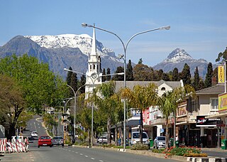
Stellenbosch is a town in the Western Cape province of South Africa, situated about 50 kilometres east of Cape Town, along the banks of the Eerste River at the foot of the Stellenbosch Mountain. The town became known as the City of Oaks or Eikestad in Afrikaans and Dutch due to the large number of oak trees that were planted by its founder, Simon van der Stel, to grace the streets and homesteads.

<span class="mw-page-title-main">Uitenhage</span> Place in Eastern Cape, South Africa

Uitenhage, officially renamed Kariega, is a South African town in the Eastern Cape Province. It is well known for the Volkswagen factory located there, which is the biggest car factory on the African continent. Along with the city of Port Elizabeth and the small town of Despatch, it forms the Nelson Mandela Bay Metropolitan Municipality.

<span class="mw-page-title-main">Graaff-Reinet</span> Place in Eastern Cape, South Africa

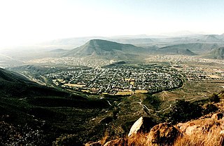
Graaff-Reinet is a town in the Eastern Cape Province of South Africa. It is the oldest town in the province and the fourth oldest town in South Africa, after Cape Town, Stellenbosch, Simon's Town, Paarl and Swellendam. The town was the centre of a short-lived republic in the late 18th century. The town was a starting point for Great Trek groups led by Gerrit Maritz and Piet Retief and furnished large numbers of the Voortrekkers in 1835–1842.

<span class="mw-page-title-main">Overberg</span> Region of the Western Cape in South Africa, east of Cape Town

Overberg is a region in South Africa to the east of Cape Town beyond the Hottentots-Holland mountains. It lies along the Western Cape Province's south coast between the Cape Peninsula and the region known as the Garden Route in the east. The boundaries of the Overberg are the Hottentots-Holland mountains in the West; the Riviersonderend Mountains, part of the Cape Fold Belt, in the North; the Atlantic and Indian Oceans in the South and the Breede River in the East.

<span class="mw-page-title-main">Swellendam Local Municipality</span> Local municipality in Western Cape, South Africa

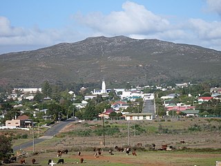
Swellendam Municipality is a local municipality located within the Overberg District Municipality, in the Western Cape province of South Africa. As of 2011, it had a population of 35,916. Its municipality code is WC034.

<span class="mw-page-title-main">Breede River</span> River in South Africa

The Breede River, also known as Breë River, is a river in the Western Cape Province of South Africa. Travelling inland north from the city of Cape Town, the river runs in a west to east direction. The surrounding western mountains formed the first continental divide experienced by European settlers in the 18th century. The Titus River and Dwars River become the Breë River.

<span class="mw-page-title-main">Worcester, South Africa</span> Town in Western Cape, South Africa

Worcester is a town in the Western Cape, South Africa. It is the third-largest city in the western cape province of South Africa. It is located 120 kilometres (75 mi) north-east of Cape Town on the N1 highway north to Johannesburg.

<span class="mw-page-title-main">Heidelberg, Western Cape</span> Place in Western Cape, South Africa

Heidelberg is a town in the Western Cape, South Africa. It is located near South Africa's south coast, on the N2 highway, within the Hessequa region, 274 km east of Cape Town. Heidelberg marks the start of the Garden Route. Heidelberg is part of the Hessequa Local Municipality.

<span class="mw-page-title-main">Wynberg, Cape Town</span> Place in Western Cape, South Africa

Wynberg is a southern suburb of the City of Cape Town in Western Cape, South Africa. It is situated between Plumstead and Kenilworth, and is a main transport hub for the Southern Suburbs of Cape Town.

<span class="mw-page-title-main">Ceres, South Africa</span> Town in Western Cape, South Africa

Ceres is the administrative centre and largest town of the Witzenberg Local Municipality in the Western Cape Province of South Africa. Ceres serves as a regional centre for the surrounding towns of Wolseley, Tulbagh, Op-die-Berg and Prince Alfred Hamlet. It is situated in the Warmbokkeveld Valley about 170 km north-east of Cape Town. Ceres is located at the north-eastern entrance to Michell's Pass and was the old route north between Cape Town and Johannesburg, which was later replaced by the N1 highway, which traverses the Breede River Valley to the south.

<span class="mw-page-title-main">Wellington, South Africa</span> Place in Western Cape, South Africa

Wellington is a town in the Western Cape Winelands, a 45-minute drive from Cape Town, in South Africa with a population of approximately 62,000. Wellington's economy is centered on agriculture such as wine, table grapes, deciduous fruit, and a brandy industry. The town is located 75 km north-east of Cape Town, reached by the N1 motorway and R44. Due to the growth of the Vlakkeland and Mbekweni township south of the town, it now forms a de facto urban unit with Paarl, just 10 km to the south. Wellington now officially falls under the Drakenstein Local Municipality, which also covers Saron and Paarl.

<span class="mw-page-title-main">Bontebok National Park</span> National park near Swellendam in the Western Cape, South Africa

Bontebok National Park is a species-specific national park in South Africa. It was established in 1931 to ensure the preservation of the Bontebok. It is the smallest of South Africa's 19 National Parks, covering an area of 27.86 km2 The park is part of the Cape Floristic Region, which is a World Heritage Site.

<span class="mw-page-title-main">Parow, South Africa</span> Place in Western Cape, South Africa

Parow is a township of Cape Town in the Western Cape, South Africa and a Northern Suburb of the City of Cape Town Metropolitan Municipality founded by Johann Heinrich Ferdinand Parow who arrived in the locality in 1865.

<span class="mw-page-title-main">Bredasdorp</span> Place in Western Cape, South Africa

Bredasdorp is a town in the Southern Overberg region of the Western Cape, South Africa, and the main economic and service hub of that region. It lies on the northern edge of the Agulhas Plain, about 160 kilometres (100 mi) south-east of Cape Town and 35 kilometres (22 mi) north of Cape Agulhas, the southernmost tip of Africa.

<span class="mw-page-title-main">Ryk Tulbagh</span> Dutch Governor of the Cape Colony

Ryk Tulbagh was Governor of the Dutch Cape Colony from 27 February 1751 to 11 August 1771 under the Dutch East India Company (VOC).

<span class="mw-page-title-main">Buffeljags River</span> River in Western Cape, South Africa

Buffeljagsriver is a river that originates where two other rivers meet, one being the Grootvadersbos River and the other the Tradou River. The confluence is just east of a small town, Suurbraak, Western Cape province. The Tradouw Pass is situated just north of this meeting point. To the west of the town the river flows into the Buffeljags Dam, and the river then heads south to join the Breede River, not far from the Bontebok National Park.

<span class="mw-page-title-main">Pieter van Reede van Oudtshoorn</span>

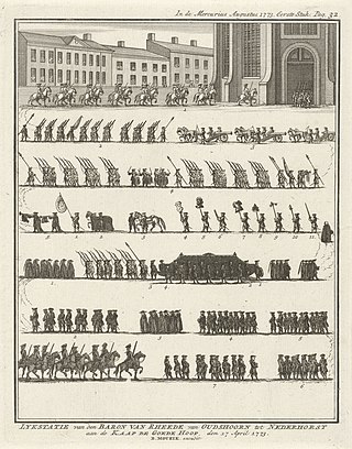
Baron Pieter van Reedevan Oudtshoorn was a senior official and Governor designate of the Dutch Cape Colony. He was appointed Governor of the Cape Colony in 1772 to succeed the deceased Governor Ryk Tulbagh but died at sea on his way to the Cape Colony to take up his post. The Western Cape town of Oudtshoorn is named after him. He is the progenitor of the van R(h)eede van Oudtshoorn family in South Africa.

<span class="mw-page-title-main">Grootvadersbosch Nature Reserve</span> South African nature reserve

Grootvadersbosch is a historic farm in the Overberg, and the surrounding area is currently a nature reserve in the southern portion of the Boosmansbos Wilderness Area, in Western Cape, South Africa.

<span class="mw-page-title-main">Republic of Swellendam</span> Short-lived Boer Republic in Southern Africa (1795)

The Republic of Swellendam was founded in 1795 with the dissatisfaction towards the Dutch East India Company caused the burghers of Swellendam to revolt, and on 17 June 1795 they declared themselves a republic. Hermanus Steyn was appointed as President of the Republic of Swellendam. The burghers of Swellendam started to call themselves "national burghers" – after the style of the French Revolution. However, the Republic was short-lived and was ended on 4 November 1795 when the Cape was occupied by the Kingdom of Great Britain.

References

  1. Robson, Linda Gillian (2011). "Annexure A" (PDF). The Royal Engineers and settlement planning in the Cape Colony 1806–1872: Approach, methodology and impact (PhD thesis). University of Pretoria. pp. xlv–lii. hdl:2263/26503.
  2. 1 2 3 4 "Sub-Place Swellendam". Census 2011.
  3. Floyd, TB (1960). "What are the Oldest Towns in South Africa?".
  4. "What are the Oldest Towns in South Africa?". 2003.
  5. "The Swellendam Republic accepts British rule". South African History Online. Retrieved 7 August 2014.
  6. Rosenthal, Eric. 1978. Encyclopaedia of Southern Africa. Cape Town and Johannesburg: Juta and Company Limited
  7. "Breede River; Western Cape; fruit; wine farms; historic towns; water sports; river rafting; angling; whale watching; Route 62 (GL)". www.southafrica.net. Retrieved 2 March 2023.
  8. Malherbe, E.G. (1939). Official Year Book of the Union of South Africa and of Basutoland, Bechuanaland Protectorate, and Swaziland. Vol. 20. Pretoria: Union of South Africa. p. 1044.
  9. "Climate: Swellendam- Climate-Data.org" . Retrieved 7 September 2020.
  10. van der Walt, J.M.; L.H. Nel; A.R. Hoelzel (2001). "Characterization of major histocompatibility complex DRB diversity in the endemic South African antelope Damaliscus pygargus: a comparison in two subspecies with different demographic histories". Molecular Ecology. 10 (7). Blackwell Science: 1679–1688. doi:10.1046/j.0962-1083.2001.01321.x. PMID   11472536. S2CID   1538591.
  11. "About Swellendam – Roosje van de Kaap" . Retrieved 2 March 2023.
  12. Pama, C. (1965) Lions and Virgins.
  13. Cape Town Gazette 418 (15 January 1814).
  14. 1 2 Western Cape Archives : Heraldic Information (CAD 1/2/16).
  15. Western Cape Archives : Swellendam Divisional Council Minutes (15 November 1974).
  16. http://www.national.archsrch.gov.za%5B%5D