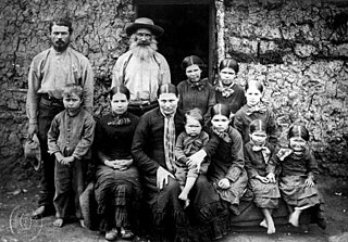
Boers are the descendants of the Dutch-speaking Free Burghers of the eastern Cape frontier in Southern Africa during the 17th, 18th, and 19th centuries. From 1652 to 1795, the Dutch East India Company controlled this area, but the United Kingdom incorporated it into the British Empire in 1806. The name of the group is derived from "boer", which means "farmer" in Dutch and Afrikaans.

The South African Republic, also known as the Transvaal Republic, was an independent Boer republic in Southern Africa which existed from 1852 to 1902, when it was annexed into the British Empire as a result of the Second Boer War.

The Transvaal Colony was the name used to refer to the Transvaal region during the period of direct British rule and military occupation between the end of the Second Boer War in 1902 when the South African Republic was dissolved, and the establishment of the Union of South Africa in 1910. The borders of the Transvaal Colony were larger than the defeated South African Republic. In 1910 the entire territory became the Transvaal Province of the Union of South Africa.

Stephanus Johannes Paulus Kruger was a South African politician. He was one of the dominant political and military figures in 19th-century South Africa, and State President of the South African Republic from 1883 to 1900. Nicknamed Oom Paul, he came to international prominence as the face of the Boer cause—that of the Transvaal and its neighbour the Orange Free State—against Britain during the Second Boer War of 1899–1902. He has been called a personification of Afrikanerdom, and remains a controversial figure; admirers venerate him as a tragic folk hero.

The Orange Free State was an independent Boer sovereign republic under British suzerainty in Southern Africa during the second half of the 19th century, which ceased to exist after it was defeated and surrendered to the British Empire at the end of the Second Boer War in 1902. It is one of the three historical precursors to the present-day Free State province.

The Great Trek was a northward migration of Dutch-speaking settlers who travelled by wagon trains from the Cape Colony into the interior of modern South Africa from 1836 onwards, seeking to live beyond the Cape's British colonial administration. The Great Trek resulted from the culmination of tensions between rural descendants of the Cape's original European settlers, known collectively as Boers, and the British Empire. It was also reflective of an increasingly common trend among individual Boer communities to pursue an isolationist and semi-nomadic lifestyle away from the developing administrative complexities in Cape Town. Boers who took part in the Great Trek identified themselves as voortrekkers, meaning "pioneers", "pathfinders" in Dutch and Afrikaans.

The Province of the Transvaal, commonly referred to as the Transvaal, was a province of South Africa from 1910 until 1994, when a new constitution subdivided it following the end of apartheid. The name "Transvaal" refers to the province's geographical location to the north of the Vaal River. Its capital was Pretoria, which was also the country's executive capital.

The Boer republics were independent, self-governing republics formed by Dutch-speaking inhabitants of the Cape Colony and their descendants. The founders – variously named Trekboers, Boers and Voortrekkers – settled mainly in the middle, northern, north-eastern and eastern parts of present-day South Africa. Two of the Boer Republics achieved international recognition and complete independence: the South African Republic and the Orange Free State. The republics did not provide for the separation of church and state, initially allowing only the Dutch Reformed Church, and later also other Protestant churches in the Calvinist tradition. The republics came to an end after the Second Boer War of 1899–1902, which resulted in British annexation and later incorporation of their lands into the Union of South Africa.

Andries Wilhelmus Jacobus Pretorius was a leader of the Boers who was instrumental in the creation of the South African Republic, as well as the earlier but short-lived Natalia Republic, in present-day South Africa. The large city of Pretoria, executive capital of South Africa, is named after him.
Klerksdorp is located in the North West Province, South Africa. Klerksdorp, the largest city in the North West Province, is located 165 km (103 mi) southeast of Mahikeng, the provincial capital. Klerksdorp was also the first capital of the then Transvaal Republic and used to be the home of the first Stock Exchange in the region. It became an important trading town linking Kimberley to Johannesburg. It became home to a mix of farmers, miners and immigrants servicing the two industries.

Winburg is a small mixed farming town in the Free State province of South Africa.
Bela-Bela, also known by its original name Warmbaths. is a town in the Limpopo Province of South Africa. Deriving its name from the geothermic hot springs around which the town was built.

The Soutpansberg, meaning "Salt Pan Mountain" in Afrikaans, is a range of mountains in far northern South Africa. It is located in Vhembe District, Limpopo. It is named for the salt pan located at its western end. The mountain range reaches the opposite extremity in the Matikwa Nature Reserve, some 107 kilometres (66 mi) due east. The range as a whole had no Venda name, as it was instead known by its sub-ranges which include Dzanani, Songozwi and others. Of late it is however known as Tha vhani ya muno, meaning "mountain of salt".

The Colony of Natal was a British colony in south-eastern Africa. It was proclaimed a British colony on 4 May 1843 after the British government had annexed the Boer Republic of Natalia, and on 31 May 1910 combined with three other colonies to form the Union of South Africa, as one of its provinces. It is now the KwaZulu-Natal province of South Africa.

The Transvaal Civil War was a series of skirmishes during the early 1860s in the South African Republic, or Transvaal, in the area now comprising the Gauteng, Limpopo, Mpumalanga, and North West provinces of South Africa. It began after the British government had recognised trekkers living in the Transvaal as independent in 1854. The Boers divided into numerous political factions. The war ended in 1864, when an armistice treaty was signed under a Karee tree south of the site of the later town of Brits.

Louis Johannes Tregardt, commonly spelled Trichardt was a farmer from the Cape Colony's eastern frontier, who became an early voortrekker leader. Shunning colonial authority, he emigrated in 1834 to live among the Xhosa across the native reserve frontier, before he crossed the Orange River into northern territory. His northward trek, along with fellow trekker Johannes (Hans) van Rensburg, was commenced in early 1836. He led his small party of emigrants, composed of seven Boer farmers, with their wives and thirty-four children & native servants, into the uncharted interior of South Africa, and settled for a year at the base of the Zoutpansberg.
Makhado was a 19th-century chief in the Singo dynasty of the Vendas. They ruled over the Dzanani "district" of the Zoutpansberg region of South Africa. He was the youngest son of khosi Ramabulana who died in 1864 when Makhado was about 25. Makhado's mother was Limani, noted for her political intrigue. Makhado's first wife was Nwaphunga. According to Venda historian M. H. Nemudzivhadi, Nwaphunga conspired with a pro-Boer faction among the Venda, and poisoned him in 1895.
Schoemansdal was a settlement situated 16 km west of Louis Trichardt (Makhado), which had its origins during the Great Trek. It existed from 1848 to 1867, and functioned as the capital of an autonomous region until the S.A.R. Volksraad was established, when the outpost came under the supervision and regulations of the central government. The settlement was evacuated after only thirty years when attacked by Venda militants. The government rendered indecisive support and the town as torched by Katze-Katze on the night of 15 July 1867.

Adam Stanley Renders was a German-American hunter, prospector and trader in southern Africa who is generally recorded as the first European to see the medieval city of Great Zimbabwe, having inadvertently come across the ruins while hunting big game in 1867. He subsequently guided the explorer and geographer Karl Mauch during the first archaeological expedition to the site in 1871, and also discovered prehistoric gold mines in the region.
The siege of Marabastad was a siege of Fort Marabastad, in present day Limpopo, South Africa, carried out by the Boer Republic of Transvaal, starting on 11 January 1881, and ending with British surrender on 2 April 1881. It took place during the First Boer War, during which Boer forces besieged several British garrisons across the country.


