
Table Bay is a natural bay on the Atlantic Ocean overlooked by Cape Town and is at the northern end of the Cape Peninsula, which stretches south to the Cape of Good Hope. It was named because it is dominated by the flat-topped Table Mountain.

Overstrand Municipality is a local municipality in the Western Cape province of South Africa. It is located along the Atlantic coast between Cape Town and Cape Agulhas, within the Overberg District Municipality. The principal towns in the municipality are Hermanus, Gansbaai and Kleinmond. As of 2011, it had a population of 80,432.

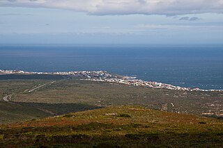
Gansbaai is a fishing town and popular tourist destination in the Overberg District Municipality, Western Cape, South Africa. It is known for its dense population of great white sharks and as a whale-watching location.

Fish Hoek is a coastal town at the eastern end of the Fish Hoek Valley on the False Bay side of the Cape Peninsula in the Western Cape, South Africa. Previously a separate municipality, Fish Hoek is now part of the City of Cape Town. As a coastal suburb of Cape Town, Fish Hoek is popular as a residence for commuters, retired people and holidaymakers alike. The traditional industries of 'trek' fishing and angling coexist with the leisure pursuits of surfing, although nearby Kommetjie is usually favoured, sailing and sunbathing. There is an active lifeguard community who utilise the beach and bay for training.

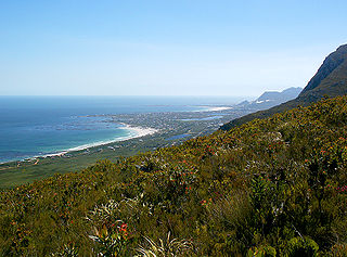
False Bay is a body of water in the Atlantic Ocean between the mountainous Cape Peninsula and the Hottentots Holland Mountains in the extreme south-west of South Africa. The mouth of the bay faces south and is demarcated by Cape Point to the west and Cape Hangklip to the east. The north side of the bay is the low-lying Cape Flats, and the east side is the foot of the Hottentots Holland Mountains to Cape Hangklip which is at nearly the same latitude as Cape Point. In plan the bay is approximately square, being roughly the same extent from north to south as east to west, with the southern side open to the ocean. The seabed slopes gradually down from north to south, and is mostly fairly flat unconsolidated sediments. Much of the bay is off the coast of the City of Cape Town, and it includes part of the Table Mountain National Park Marine Protected Area and the whole of the Helderberg Marine Protected Area. The name "False Bay" was applied at least three hundred years ago by sailors returning from the east who confused Cape Point and Cape Hangklip, which are somewhat similar in profile when approached from the southeast.

Arniston is a small seaside settlement on the coast of the Overberg region of South Africa, close to Cape Agulhas, the southernmost tip of Africa. Prior to the wreck of Arniston, it is also known as Waenhuiskrans, an Afrikaans name meaning literally "Wagon house cliff", after a local sea cave large enough to accommodate a wagon and a span of oxen.
Muizenberg is a beach-side town in the Western Cape, South Africa. It is situated where the shore of the Cape Peninsula curves round to the east on the False Bay coast. It is considered to be the main surfing spot in Cape Town and is currently home to a surfing community, centered on the popular 'Surfer's Corner'.
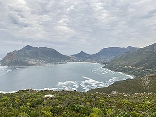
Hout Bay is a seaside suburb of Cape Town in the Western Cape province of South Africa. It is situated in a valley on the Atlantic seaboard of the Cape Peninsula, twenty kilometres south of the Central business district of Cape Town. The name "Hout Bay" can refer to the town, the bay on which it is situated, or the entire valley.
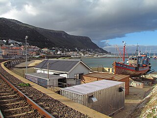
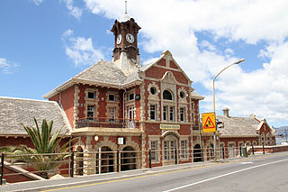
Kalk Bay is a fishing village and suburb of Cape Town. It lies on the east coast of False Bay with much of the town built on the slopes of mountains which border the sea, with peaks of Table Mountain Sandstone forming valleys. The railway from Cape Town to Simon's Town passes through Kalk Bay, which has one station near the harbour.

Helderberg refers to a planning district of the City of Cape Town metropolitan municipality, the mountain after which it is named, a wine-producing area in the Western Cape province of South Africa, or a small census area in Somerset West.
Betty's Bay is a small holiday town situated on the Overberg coast of South Africa's Western Cape province. It is located 100 km from Cape Town beneath the Kogelberg Mountains on the scenic R44 ocean drive between Pringle Bay and Kleinmond. This village stretches over 13 km along the coast. Tourism plays a large role in the town's economy due to its popularity with holiday makers from across the Western Cape and Cape Town in particular.

Kleinmond is a small coastal town in the Overberg region of the Western Cape province, South Africa. It is situated inside a UNESCO-declared biosphere about 90 km east of Cape Town between Betty's Bay and Hermanus. The town's name, meaning "small mouth" in Afrikaans, refers to its location at the mouth of the Bot River lagoon. Stone axe heads found in the area indicate that people already lived in the vicinity of nearby Hangklip 20,000 years ago. Information about the area has existed in writing since the seventeenth century.

Vice-Admiral Thomas Pringle was a British officer of the Royal Navy. He served during the American War of Independence, and the French Revolutionary and Napoleonic Wars.

Cape Town lies at the south-western corner of the continent of Africa. It is bounded to the south and west by the Atlantic Ocean, and to the north and east by various other municipalities in the Western Cape province of South Africa.
The Fish Hoek Valley is situated in the Cape Peninsula, eighteen miles south of Cape Town, South Africa. It takes its name from the town of Fish Hoek on the False Bay coast.
De Kelders is a coastal village in the Overberg District Municipality, Western Cape, South Africa.

Rooiels is a settlement in Overberg District Municipality in the Western Cape province of South Africa. It was declared a township in June 1948, and is situated 5 km north of Pringle Bay, on the eastern shore of False Bay. It was named after the farm and river of the same name, which were named after the red alder tree known as rooiels in Afrikaans.
Wolvengat, also known as Viljoenshof, is a village in the southern Overberg region, in the Western Cape province of South Africa. It is situated 10 kilometres (6 mi) south of Elim and 35 kilometres (22 mi) southwest of Bredasdorp. It was originally named Wolfgat or Wolvengat in reference to the brown hyena, known as strandwolf in Afrikaans. However, when the local post office was established the authorities named it Viljoenshof in honour of DJ Viljoen, the Dutch Reformed (NGK) minister of Bredasdorp from 1904 to 1934; this name was then extended to the village. The original name Wolvengat was officially restored in 1991.

The Table Mountain National Park Marine Protected Area is an inshore marine protected area around the Cape Peninsula, in the vicinity of Cape Town, South Africa. It was proclaimed in Government Gazette No. 26431 of 4 June 2004 in terms of the Marine Living Resources Act, 18 of 1998.

Clarence Drive is a mountain pass crossed by the R44 road between Gordon's Bay and Rooi-Els. The tourist route is 22 km long and provides a panoramic view of False Bay, the coastline, Table Mountain, and parts of the Cape Peninsula. The nearby coast is popular with anglers and whale watchers, and Kogel Bay Resort is particularly sought after by surfers.


