
Birkenhead is a town in the Metropolitan Borough of Wirral, Merseyside, England; historically, until 1974, in Cheshire. It is on the Wirral Peninsula, along the south bank of the River Mersey, opposite the city of Liverpool. At the 2011 census, it had a population of 88,818.

Wirral, also known as The Wirral, is a peninsula in North West England. The roughly rectangular peninsula is about 15 miles (24 km) long and 7 miles (11 km) wide and is bounded by the River Dee to the west that forms a boundary with Wales, the River Mersey to the east, and the Irish Sea to the north.

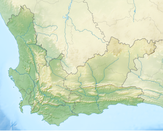
Overstrand Municipality is a local municipality in the Western Cape province of South Africa. It is located along the Atlantic coast between Cape Town and Cape Agulhas, within the Overberg District Municipality. The principal towns in the municipality are Hermanus, Gansbaai and Kleinmond. As of 2011 it had a population of 80,432.

Cape Agulhas Municipality is a municipality located in the Western Cape Province of South Africa. As of 2011 it had a population of 33,038. Its municipality code is WC033. It is named after Cape Agulhas, the southernmost point of Africa. The largest town is Bredasdorp, which is the seat of the municipal headquarters. It also includes the villages of Napier, Struisbaai, Elim, Arniston and L'Agulhas, and the De Hoop Nature Reserve.

The Overberg District Municipality is a district municipality that governs the Overberg region in the Western Cape province of South Africa. It is divided into four local municipalities and includes the major towns of Grabouw, Caledon, Hermanus, Bredasdorp and Swellendam. The municipal area covers 12,241 square kilometres (4,726 sq mi) and had in 2007 an estimated population of 212,787 people in 60,056 households.

Overstrand is a village on the north coast of Norfolk in England, two miles east of Cromer. It was once a modest fishing station, with all or part of the fishing station being known as Beck Hythe. In the latter part of the 19th century it was catapulted into prominence, and became known as “the village of millionaires”.

Gansbaai is a fishing town and popular tourist destination in the Overberg District Municipality, Western Cape, South Africa. It is known for its dense population of great white sharks and as a whale-watching location.
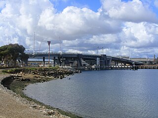
Birkenhead is a north-western suburb of Adelaide 14 km from the CBD, on the Lefevre Peninsula, in South Australia, and lies within the City of Port Adelaide Enfield. It is adjacent to Peterhead, Exeter and Glanville. It is bounded to the south by the Gawler Reach of the Port River, to the north by Hargrave Street and in the west and east by the Outer Harbor railway line and the Port River respectively.

Claughton is a village and suburb of Birkenhead, on the Wirral Peninsula, Merseyside, England. It is situated approximately 3 km (1.9 mi) to the west of Birkenhead town centre, adjacent to Birkenhead Park. Administratively, Claughton is a ward of the Metropolitan Borough of Wirral. Before local government reorganisation on 1 April 1974, it was part of the County Borough of Birkenhead, within the county of Cheshire.

Birkenhead Transport was a bus operator in Birkenhead. It commenced operating on 12 July 1919 with a service from Rock Ferry to Birkenhead Park station, this service was extended to Moreton in the August of that year. The buses supplemented an earlier tram service.
The Bishop of Birkenhead is an episcopal title used by a suffragan bishop of the Church of England Diocese of Chester, in the Province of York, England. The title takes its name after Birkenhead, a town located on the Wirral Peninsula.
Salmonsdam Nature Reserve is a nature reserve in the Overberg region of the Western Cape province of South Africa. It contains the mountain catchment area of the Paardensberg River in the Akkedisberg mountains. The reserve is administered by CapeNature and covers an area of 834 hectares.

Hawston is a village in the Western Cape, South Africa, It is a fishing village north-east of Mudge Point, 5 km north-west of Onrusrivier and 11 km from Hermanus. It is named after C.R. Haw, a civil commissioner of Caledon.

Birkenhead Sixth Form College specialises in A Level & BTEC education and is rated as 'Outstanding' by Ofsted. In February 2018, TES FE Awards named the College UK 'Sixth Form College of the Year'. It is Wirral's only specialist sixth form provider, with teachers that solely teach A Level and BTECs to ages 16+.
Franskraalstrand, also known as Franskraal, is a coastal village near to Gansbaai in the Western Cape province of South Africa. As of 2011 it had a population of 1,165 people in 592 households.

The District Council of Lefevre's Peninsula was a local government area in South Australia centred on the Lefevre Peninsula from 1872 to 1884.
The District Council of Birkenhead was a local government area in South Australia centred on the suburb of Birkenhead. It was gazetted on 22 February 1877 from areas formerly part of the District Council of Lefevre's Peninsula. The council chambers were based out of the Birkenhead Hotel. It absorbed the remainder of the Lefevre's Peninsula council, which had been severely reduced in size by the creation of the Corporate Town of Semaphore, on 7 August 1884. It ceased to exist when it merged with the Corporate Town of Port Adelaide on 7 December 1886 as the Birkenhead Ward, a move supported by the council and the local population.

The Hundred of Port Adelaide is a cadastral hundred covering the vicinity of Port Adelaide, Lefevre Peninsula and the coast of the central Adelaide Plains south of Gawler River and west of Port Wakefield Road. It is one of the eleven hundreds of the County of Adelaide and was named in 1846 by Governor Frederick Robe.
The council of the Overstrand Local Municipality in the Western Cape, South Africa is elected every five years by a system of mixed-member proportional representation. Half of the councillors are elected by first-past-the-post voting from individual wards, while the other half are appointed from party lists so that the total number of party representatives is proportional to the number of votes received. By-elections are held to replace the councillors elected by wards if a vacancy occurs.

Overstrand Cliffs is a 57.8-hectare (143-acre) biological and geological Site of Special Scientific Interest in Cromer in Norfolk. It is a Special Area of Conservation and part of it is a Geological Conservation Review site.


