Dutch Cape Colony

Last updated

Cape Colony
Kaapkolonie (Dutch)
1652–1806
Map of the Dutch Cape Colony in 1795.jpg
VOC Cape Colony at its largest extent in 1795
StatusColony under Company rule (1652–1795)
British occupation (1795–1803)
Colony of the Batavian Republic (1803–1806)
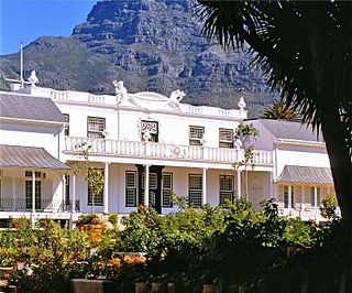
Capital Castle of Good Hope (1st)
Kaapstad (2nd)
Official language Dutch
Common languages
Afrikaans
Xiri
!Orakobab (Korana language)
Khoekhoe
isiXhosa
Religion
Dutch Reformed
native beliefs
Governor 
 1652–1662
Jan van Riebeeck
 1662–1666
Zacharias Wagenaer
 1771–1785
Joachim van Plettenberg
 1803–1806
Jan Willem Janssens
Historical era Colonialism
6 April 1652
 Elevated to Governorate
1691
7 August 1795
1 March 1803
8 January 1806
Population
 1797 [1]
61,947
Currency Dutch rijksdaalder
Preceded by
Succeeded by
Blank.png Khoekhoe people
British Cape Colony Flag of the Cape Colony (1876-1910).svg
Republic of Graaff-Reinet Mixed flag of Republic of Graaff-Reinet.png
Republic of Swellendam Mixed flag of Republic of Swellendam.png
Today part of South Africa

The Cape Colony (Dutch : Kaapkolonie) was a Dutch United East India Company (VOC) colony in Southern Africa, centered on the Cape of Good Hope, from where it derived its name. The original colony and the successive states that the colony was incorporated into occupied much of modern South Africa. Between 1652 and 1691, it was a Commandment, and between 1691 and 1795, a Governorate of the VOC. Jan van Riebeeck established the colony as a re-supply and layover port for vessels of the VOC trading with Asia. [2] The Cape came under VOC rule from 1652 to 1795 and from 1803 to 1806 was ruled by the Batavian Republic. [3] Much to the dismay of the shareholders of the VOC, who focused primarily on making profits from the Asian trade, the colony rapidly expanded into a settler colony in the years after its founding.

Contents

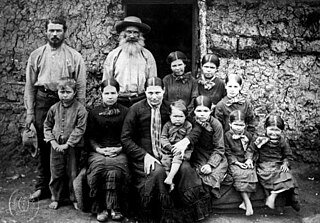
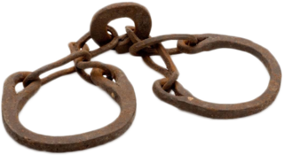
As the only permanent settlement of the Dutch United East India Company not serving as a trading post, it proved an ideal retirement place for employees of the company. After several years of service in the company, an employee could lease a piece of land in the colony as a Vryburgher ('free citizen'), on which he had to cultivate crops that he had to sell to the United East India Company for a fixed price. As these farms were labour-intensive, Vryburghers imported slaves from Madagascar, Mozambique and Asia (Dutch East Indies and Dutch Ceylon), which rapidly increased the number of inhabitants. [2] After King Louis XIV of France issued the Edict of Fontainebleau in October 1685 (revoking the Edict of Nantes of 1598), thereby ending protection of the right of Huguenots in France to practise Protestant worship without persecution from the state, the colony attracted many Huguenot settlers, who eventually mixed with the general Vryburgher population.

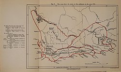
Due to the authoritarian rule of the company (telling farmers what to grow for what price, controlling immigration, and monopolising trade), some farmers tried to escape the rule of the company by moving further inland. The company, in an effort to control these migrants, established a magistracy at Swellendam in 1745 and another at Graaff Reinet in 1786, and declared the Gamtoos River as the eastern frontier of the colony, only to see the Trekboers cross it soon afterwards. In order to keep out Cape native pastoralists, organised increasingly under the resisting, rising house of Xhosa, the VOC agreed in 1780 to make the Great Fish River the boundary of the colony.

In 1795, after the Battle of Muizenberg in present-day Cape Town, the British occupied the colony. Under the terms of the Peace of Amiens of 1802, Britain ceded the colony back to the Dutch on 1 March 1803, but as the Batavian Republic had since nationalized the United East India Company (1796), the colony came under the direct rule of The Hague. Dutch control did not last long, however, as the outbreak of the Napoleonic Wars (18 May 1803) invalidated the Peace of Amiens. In January 1806, the British occupied the colony for a second time after the Battle of Blaauwberg at present-day Bloubergstrand. The Anglo-Dutch Treaty of 1814 confirmed the transfer of sovereignty to Great Britain.

History

United East India Company

Replica of an East Indiaman of the VOC/United East Indies Company Vereenigde Oostindische Compagnie spiegelretourschip Amsterdam replica.jpg
Replica of an East Indiaman of the VOC/United East Indies Company
View of Table Bay with ships of the United East India Company (VOC), c. 1683 Aernout Smit Table Bay, 1683 William Fehr Collection Cape Town.jpg
View of Table Bay with ships of the United East India Company (VOC), c. 1683
Painting of an account of the arrival of Jan van Riebeeck, by Charles Bell Charles Bell - Jan van Riebeeck se aankoms aan die Kaap.jpg
Painting of an account of the arrival of Jan van Riebeeck, by Charles Bell
Drawing of a group of Khoidi women, made by a Dutch artist in the early 1700s Khoi Women and Dutch Colonist WDL11267.png
Drawing of a group of Khoidi women, made by a Dutch artist in the early 1700s

Traders of the United East India Company (VOC), under the command of Jan van Riebeeck, were the first people to establish a European colony in South Africa. The Cape settlement was built by them in 1652 as a re-supply point and way-station for United East India Company vessels on their way back and forth between the Netherlands and Batavia (Jakarta) in the Dutch East Indies. The support station gradually became a settler community, the forebears of the Boers, and the Cape Dutch who collectively became modern-day Afrikaners.

Khoi people of the Cape

At the time of first European settlement in the Cape, the southwest of Africa was inhabited by Khoikhoi pastoralists and hunters, The Khoina ("People") were disgruntled by the disruption of their seasonal visit to the area for which purpose they grazed their cattle at the foot of Table Mountain only to find European settlers occupying and farming the land, leading to the first Khoi-Dutch War as part of a series of Khoekhoe-Dutch Wars. After the war, the natives ceded the land to the settlers in 1660. During a visit in 1672, the high-ranking Commissioner Arnout van Overbeke made a formal purchase of the Cape territory, although already ceded in 1660, his reason was to "prevent future disputes". [4]

The ability of the European settlers to produce food at the Cape initiated the decline of the nomadic lifestyle of the Khoe and Tuu speaking peoples since food was produced at a fixed location. Thus by 1672, the permanent indigenous residents living at the Cape had grown substantially. The first school to be built in South Africa by the settlers were for the sake of the slaves who had been rescued from a Portuguese slave ship and arrived at the Cape with the Amersfoort in 1658. Later on, the school was also attended by the children of the indigenes and the Free Burghers. The Dutch language was taught at schools as the main medium for commercial purposes, with the result that the indigenous people and even the French settlers found themselves speaking Dutch more than their native languages. The principles of Christianity were also introduced at the school resulting in the baptisms of many slaves and indigenous residents. [4]

Conflicts with the settlers and the effects of smallpox decimated their numbers in 1713 and 1755, until gradually the breakdown of their society led them to be scattered and ethnically cleansed beyond the colonial frontiers: both beyond the Eastward-expanding frontier (to form eventually the future resisting population of the frontier wars), as well as beyond the Northern open frontier above the Great Escarpment. [5]

Some worked for the colonists, mostly as shepherds and herdsmen. [6]

Free Burghers

The VOC favoured the idea of freemen at the Cape and many settlers requested to be discharged in order to become free burghers; as a result, Jan van Riebeeck approved the notion on favorable conditions and earmarked two areas near the Liesbeek River for farming purposes in 1657. The two areas which were allocated to the freemen, for agricultural purposes, were named Groeneveld and Dutch Garden. These areas were separated by the Amstel River (Liesbeek River). Nine of the best applicants were selected to use the land for agricultural purposes. The freemen or free burghers as they were afterwards termed, thus became subjects, and were no longer servants, of the company. [7]

Trekboers

After the first settlers spread out around the Company station, nomadic European livestock farmers, or Trekboeren, moved more widely afield, leaving the richer, but limited, farming lands of the coast for the drier interior tableland. There they contested still wider groups of Khoe-speaking cattle herders for the best grazing lands.

The Cape society in this period was thus a diverse one. The emergence of Afrikaans reflects this diversity, from its roots as a Dutch pidgin, to its subsequent creolisation and use as "Kitchen Dutch" by slaves and serfs of the colonials, and its later use in Cape Islam by them when it first became a written language that used the Arabic letters. By the time of British rule after 1795, the sociopolitical foundations were firmly laid.

British conquest

Map of the Cape Colony in 1809 Cape Colony00.jpg
Map of the Cape Colony in 1809

In 1795, France occupied the Dutch Republic. This prompted Great Britain, at war with France, to occupy the territory that same year as a way to better control the seas on the way to India. The British sent a fleet of nine warships which anchored at Simon's Town and, following the defeat of the Dutch militia at the Battle of Muizenberg, took control of the territory. The United East India Company transferred its territories and claims to the Batavian Republic (the Dutch sister republic established by France) in 1798, then ceased to exist in 1799. Improving relations between Britain and Napoleonic France, and its vassal state the Batavian Republic, led the British to hand the Cape Colony over to the Batavian Republic in 1803, under the terms of the Treaty of Amiens.

In 1806, the Cape, now nominally controlled by the Batavian Republic, was occupied again by the British after their victory in the Battle of Blaauwberg. The peace between Britain and Napoleonic France had broken after one year, while Napoleon had been strengthening his influence on the Batavian Republic (which he would replace with a monarchy later that year). The British established their colony to control the Far East trade routes. In 1814 the Dutch government formally ceded sovereignty over the Cape to the British, under the terms of the Convention of London.

Administrative divisions

Administrative divisions of the Cape Colony on the eve of the 1795 British occupation Map of the Dutch Cape Colony in 1795.jpg
Administrative divisions of the Cape Colony on the eve of the 1795 British occupation

The Dutch Cape Colony was divided into four districts. In 1797 their "recorded" populations were: [8]

DistrictFree ChristiansSlaves"Hottentots"Total (1797)
District of the Cape6,26111,891-18,152
District of Stellenbosch and Drakenstein 7,25610,7035,00022,959
District of Zwellendam 3,9672,1965006,663
District of Graaff Reynet 4,2629648,94714,173

Commanders and Governors of the Cape Colony (1652–1806)

The title of the founder of the Cape Colony, Jan van Riebeeck, was installed as "Commander of the Cape", a position he held from 1652 to 1662. During the tenure of Simon van der Stel, the colony was elevated to the rank of a governorate, hence he was promoted to the position of "Governor of the Cape".

Jan van Riebeeck Jan van Riebeeck.jpg
Jan van Riebeeck
Meeting between Governor Janssens and the Xhosa leader Gaika, 1803 Ontmoeting tussen gouverneur-generaal Janssens en de Xhosa leider Gaika, 1803 Bijeenkomst van den Hoog Ed. Gestr. Heer Generaal J.W. Janssens. Gouverneur van de Kaap de Goede Hoop, met het Opperste Hoofd der Kaffers. Ga, RP-P-OB-75.374.jpg
Meeting between Governor Janssens and the Xhosa leader Gaika, 1803
Commanders of the Cape Colony (1652–1691)
NamePeriodTitle
Jan van Riebeeck 7 April 1652 – 6 May 1662Commander
Zacharias Wagenaer 6 May 1662 – 27 September 1666Commander
Cornelis van Quaelberg 27 September 1666 – 18 June 1668Commander
Jacob Borghorst 18 June 1668 – 25 March 1670Commander
Pieter Hackius 25 March 1670 – 30 November 1671Commander and Governor
1671–1672Acting Council
Albert van Breugel April 1672 – 2 October 1672Acting Commander
Isbrand Goske 2 October 1672 – 14 March 1676Governor
Johan Bax van Herenthals 14 March 1676 – 29 June 1678Commander
Hendrik Crudop 29 June 1678 – 12 October 1679Acting Commander
Simon van der Stel 10 December 1679 – 1 June 1691Commander, after 1691 Governor
Governors of the Cape Colony (1691–1795)
NamePeriodTitle
Simon van der Stel 1 June 1691 – 2 November 1699Governor
Willem Adriaan van der Stel 2 November 1699 – 3 June 1707Governor
Johan Cornelis d'Ableing 3 June 1707 – 1 February 1708Acting Governor
Louis van Assenburgh 1 February 1708 – 27 December 1711Governor
Willem Helot (acting)27 December 1711 – 28 March 1714Acting Governor
Maurits Pasques de Chavonnes 28 March 1714 – 8 September 1724Governor
Jan de la Fontaine (acting)8 September 1724 – 25 February 1727Acting Governor
Pieter Gysbert Noodt 25 February 1727 – 23 April 1729Governor
Jan de la Fontaine 23 April 1729 – 8 March 1737Acting Governor
Jan de la Fontaine 8 March 1737 – 31 August 1737Governor
Adriaan van Kervel 31 August 1737 – 19 September 1737 (died after three weeks in office)Governor
Daniël van den Henghel 19 September 1737 – 14 April 1739Acting Governor
Hendrik Swellengrebel 14 April 1739 – 27 February 1751Governor
Ryk Tulbagh 27 February 1751 – 11 August 1771Governor
Baron Joachim van Plettenberg 12 August 1771 – 18 May 1774Acting Governor
Baron Pieter van Reede van Oudtshoorn 1772 – 23 January 1773 (died at sea on his way to the Cape)Governor designate
Baron Joachim van Plettenberg 18 May 1774 – 14 February 1785Governor
Cornelis Jacob van de Graaff 14 February 1785 – 24 June 1791Governor
Johan Isaac Rhenius 24 June 1791 – 3 July 1792Acting Governor
Sebastiaan Cornelis Nederburgh and
Simon Hendrik Frijkenius
3 July 1792 – 2 September 1793Commissioners-General
Abraham Josias Sluysken 2 September 1793 – 16 September 1795Commissioner-General
Governors of the First British occupation (1797–1803)
NamePeriodTitle
George Macartney, 1st Earl Macartney 1797–1798Governor
Francis Dundas (1st time)1798–1799Acting Governor
Sir George Yonge 1799–1801Governor
Francis Dundas (2nd time)1801–1803Governor
Governors of the Cape Colony for the Batavian Republic (1803–1806)
NamePeriodTitle
Jacob Abraham Uitenhage de Mist 1803–1804Governor
Jan Willem Janssens 1804–1807Governor

Related Research Articles

<span class="mw-page-title-main">Boers</span> Descendants of Afrikaners beyond the Cape Colony frontier

Boers are the descendants of the proto Afrikaans-speaking Free Burghers of the eastern Cape frontier in Southern Africa during the 17th, 18th, and 19th centuries. From 1652 to 1795, the Dutch East India Company controlled Dutch Cape Colony, but the United Kingdom incorporated it into the British Empire in 1806. The name of the group is derived from Trekboer then later "boer", which means "farmer" in Dutch and Afrikaans.

<span class="mw-page-title-main">Dutch East India Company</span> 1602–1799 Dutch trading company

The United East India Company, commonly known as the Dutch East India Company, was a chartered trading company and the first joint-stock company in the world. Established on 20 March 1602 by the States General of the Netherlands amalgamating existing companies, it was granted a 21-year monopoly to carry out trade activities in Asia. Shares in the company could be purchased by any citizen of the United Provinces and then subsequently bought and sold in open-air secondary markets. The company possessed quasi-governmental powers, including the ability to wage war, imprison and execute convicts, negotiate treaties, strike its own coins, and establish colonies. Also, because it traded across multiple colonies and countries from both the East and the West, the VOC is sometimes considered to have been the world's first multinational corporation.

<span class="mw-page-title-main">Cape Colony</span> British colony from 1806 to 1910

The Cape Colony, also known as the Cape of Good Hope, was a British colony in present-day South Africa named after the Cape of Good Hope. It existed from 1795 to 1802, and again from 1806 to 1910, when it united with three other colonies to form the Union of South Africa, then became the Cape Province, which existed even after 1961, when South Africa had become a republic, albeit, temporarily outside the Commonwealth of Nations (1961–94).

<span class="mw-page-title-main">History of South Africa</span>

The very first modern humans are believed to have inhabited South Africa more than 100,000 years ago. In 1999, Unesco designated the region the Cradle of Humankind World Heritage site. South Africa's first known inhabitants have been referred to as the Khoisan, the Khwe and the San. Starting in about 1,000 BCE, these groups were then joined by the Bantu tribes who migrated from Western and Central Africa during what is known as the Bantu expansion.

The written history of the Cape Colony in what is now South Africa began when Portuguese navigator Bartolomeu Dias became the first modern European to round the Cape of Good Hope in 1488. In 1497, Vasco da Gama sailed along the whole coast of South Africa on his way to India, landed at St Helena Bay for 8 days, and made a detailed description of the area. The Portuguese, attracted by the riches of Asia, made no permanent settlement at the Cape Colony. However, the Dutch East India Company (VOC) settled the area as a location where vessels could restock water and provisions.

<span class="mw-page-title-main">Jan van Riebeeck</span> Dutch colonial governor (1619–1677)

Johan Anthoniszoon "Jan" van Riebeeck was a Dutch navigator and colonial administrator of the Dutch East India Company.

<span class="mw-page-title-main">Great Trek</span> 1836–1852 Boer migrations away from the British Cape Colony

The Great Trek was a northward migration of Dutch-speaking settlers who travelled by wagon trains from the Cape Colony into the interior of modern South Africa from 1836 onwards, seeking to live beyond the Cape's British colonial administration. The Great Trek resulted from the culmination of tensions between rural descendants of the Cape's original European settlers, known collectively as Boers, and the British Empire. It was also reflective of an increasingly common trend among individual Boer communities to pursue an isolationist and semi-nomadic lifestyle away from the developing administrative complexities in Cape Town. Boers who took part in the Great Trek identified themselves as voortrekkers, meaning "pioneers", "pathfinders" in Dutch and Afrikaans.

<span class="mw-page-title-main">Boer republics</span> Former countries in southern Africa

The Boer republics were independent, self-governing republics formed by Dutch-speaking inhabitants of the Cape Colony and their descendants. The founders – variously named Trekboers, Boers and Voortrekkers – settled mainly in the middle, northern, north-eastern and eastern parts of present-day South Africa. Two of the Boer republics achieved international recognition and complete independence: the South African Republic and the Orange Free State. The republics did not provide for the separation of church and state, initially allowing only the Dutch Reformed Church, and later also other Protestant churches in the Calvinist tradition. The republics came to an end after the Second Boer War of 1899–1902, which resulted in British annexation and later incorporation of their lands into the Union of South Africa.

<span class="mw-page-title-main">Trekboers</span> Historical group of pastoralists in Southern Africa

The Trekboers were nomadic pastoralists descended from European settlers on the frontiers of the Dutch Cape Colony in Southern Africa. The Trekboers began migrating into the interior from the areas surrounding what is now Cape Town, such as Paarl, Stellenbosch, and Franschhoek, during the late 17th century and throughout the 18th century. The Trekboer includes mixed-race families of partial Khoikoi descent that had also become established within the economic class of burghers.

<span class="mw-page-title-main">Swellendam</span> Town in Western Cape, South Africa

Swellendam is the fourth oldest town in South Africa, a town with 17,537 inhabitants situated in the Western Cape province. The town has over 50 provincial heritage sites, most of them buildings of Cape Dutch architecture. Swellendam is situated on the N2, approximately 220 km from both Cape Town and George.

Jan van Riebeeck landed at the Cape on 6 April 1652, setting up a supply station and fortifications for the Dutch East India Company. The decade saw the beginning of European settlement, marked by the introduction of crops from Europe and the New World and culminating in war with the Khoikhoi in 1659.

<span class="mw-page-title-main">Castle of Good Hope</span> 17th-century bastion fort in Cape Town, South African

The Castle of Good Hope is a bastion fort built in the 17th century in Cape Town, South Africa. Originally located on the coastline of Table Bay, following land reclamation the fort is now located inland. In 1936 the Castle was declared a historical monument and following restorations in the 1980s it is considered the best preserved example of a Dutch East India Company fort.

<span class="mw-page-title-main">Tuynhuys</span> Office of the president of South Africa

De Tuynhuys is the office of the president of South Africa, located in Cape Town.

The area known today as Cape Town has no written history before it was first mentioned by Portuguese explorer Bartholomeu Dias in 1488. The German anthropologist Theophilus Hahn recorded that the original name of the area was '||Hui !Gais' – a toponym in the indigenous Khoi language meaning "where clouds gather."

<span class="mw-page-title-main">Battle of Blaauwberg</span> Part of the Napoleonic Wars (1806)

The Battle of Blaauwberg, also known as the Battle of Cape Town, fought near Cape Town on Wednesday 8 January 1806, was a small but significant military engagement during the War of the Third Coalition, one of the Napoleonic Wars. After a British victory, peace was made under the Treaty Tree in Woodstock establishing British control over the Dutch Cape Colony. The Cape later became a permanent part of the British Empire following the Congress of Vienna that marked the end of the Napoleonic Wars in 1814. By establishing permanent British rule over the Cape Colony the battle would have many ramifications for the southern Africa region during the nineteenth and twentieth centuries. A bi-centennial commemoration was held in January 2006.

Although the Portuguese basked in the nautical achievement of successfully navigating the cape, they showed little interest in colonization. The area's fierce weather and rocky shoreline posed a threat to their ships, and many of their attempts to trade with the local Khoikhoi ended in conflict. The Portuguese found the Mozambican coast more attractive, with appealing bays to use as waystations, prawns, and links to gold ore in the interior.

<span class="mw-page-title-main">Afrikaners</span> Southern African settlers descended from predominantly Dutch settlers

Afrikaners are a Southern African ethnic group descended from predominantly Dutch settlers first arriving at the Cape of Good Hope in 1652. Until 1994, they dominated South Africa's politics as well as the country's commercial agricultural sector.

<span class="mw-page-title-main">Slavery in South Africa</span> Slavery in the Cape Colony

Slavery in South Africa existed from 1653 in the Dutch Cape Colony until the abolition of slavery in the British Cape Colony on 1 January 1834. This followed the British banning the trade of slaves between colonies in 1807, with their emancipation by 1834. Beyond legal abolition, slavery continued in the Transvaal though a system of inboekstelsel.

German South Africans refers to South Africans who have full or partial German heritage.

References

  1. Robert Montgomery Martin (1836). The British Colonial Library: In 12 volumes. Mortimer. p. 112.
  2. 1 2 "Kaap de Goede Hoop". De VOC site. Archived from the original on 6 May 2019. Retrieved 8 February 2013.
  3. J. A. Heese, Die Herkoms van die Afrikaner 1657–1867. A. A. Balkema, Kaapstad, 1971. CD Colin Pretorius 2013. ISBN   978-1-920429-13-3. Bladsy 15.
  4. 1 2 History of South Africa, 1484–1691, G.M. Theal, London 1888
  5. Penn, Nigel G (1995). "The Northern Cape Frontier Zone 1700- c.1815" (PDF). The Northern Cape Frontier Zone 1700- c.1815.
  6. Newmark, S. Daniel. The South African Frontier: Economic Influences 1652–1836. Stanford University Press. pp. 10–11. ISBN   978-0-8047-1617-8.
  7. Precis of the Archives of the Cape of Good Hope, January 1652 - December 1658, Riebeeck's Journal, H.C.V. Leibrandt, pp. 47–48
  8. Sir John Barrow (1806). Travels into the Interior of Southern Africa. T. Cadell and W. Davies. p.  25.

Sources