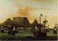
Cape Town is the legislative capital of South Africa. It is the country's oldest city and the seat of the Parliament of South Africa. It is the country's second-largest city, after Johannesburg, and the largest in the Western Cape. The city is part of the City of Cape Town metropolitan municipality.

Robben Island is an island in Table Bay, 6.9 kilometres (4.3 mi) west of the coast of Bloubergstrand, north of Cape Town, South Africa. It takes its name from the Dutch word for seals (robben), hence the Dutch/Afrikaans name Robbeneiland, which translates to Seal(s) Island.
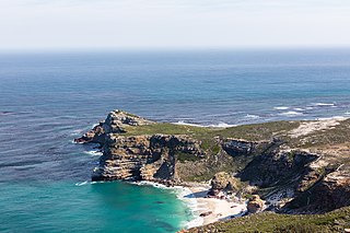
The Cape of Good Hope is a rocky headland on the Atlantic coast of the Cape Peninsula in South Africa.

Table Mountain is a flat-topped mountain forming a prominent landmark overlooking the city of Cape Town in South Africa. It is a significant tourist attraction, with many visitors using the cableway or hiking to the top. Table Mountain National Park is the most visited national park in South Africa, attracting 4.2 million people every year for various activities. The mountain has 8,200 plant species, of which around 80% are fynbos, meaning fine bush. It forms part of the Table Mountain National Park, and part of the lands formerly ranged by Khoe-speaking clans, such as the !Uriǁʼaes. It is home to a large array of mostly endemic fauna and flora.

The V&A Waterfront is a mixed-use destination located in the oldest working harbour in the Southern Hemisphere. With Table Mountain as its backdrop, the 123-hectare neighbourhood is located within the Cape Town, South Africa, where millions of people visit each year. It contains art, entrepreneurs, and sustainable design.

Cape Point is a promontory at the southeast corner of the Cape Peninsula, a mountainous and scenic landform that runs north-south for about thirty kilometres at the extreme southwestern tip of the African continent in South Africa. Table Mountain and the city of Cape Town are close to the northern extremity of the same peninsula. The cape is located at 34°21′26″S18°29′51″E, about 2.3 kilometres (1.4 mi) east and a little north of the Cape of Good Hope on the southwest corner. Although these two rocky capes are very well known, neither cape is actually the southernmost point of the mainland of Africa; that is Cape Agulhas, approximately 150 kilometres (93 mi) to the east-southeast.

Toronto Harbour or Toronto Bay is a natural bay on the north shore of Lake Ontario, in Toronto, Ontario, Canada. Today, the harbour is used primarily for recreational boating, including personal vessels and pleasure boats providing scenic or party cruises. Ferries travel from docks on the mainland to the Islands, and cargo ships deliver aggregates and raw sugar to industries located in the harbour. Historically, the harbour has been used for military vessels, passenger traffic and cargo traffic. Waterfront uses include residential, recreational, cultural, commercial and industrial sites.

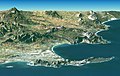
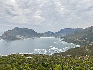
The Cape Peninsula is a generally mountainous peninsula that juts out into the Atlantic Ocean at the south-western extremity of the African continent. At the southern end of the peninsula are Cape Point and the Cape of Good Hope. On the northern end is Table Mountain, overlooking Table Bay and the City Bowl of Cape Town, South Africa. The peninsula is 52 km long from Mouille point in the north to Cape Point in the south. The Peninsula has been an island on and off for the past 5 million years, as sea levels fell and rose with the ice age and interglacial global warming cycles of, particularly, the Pleistocene. The last time that the Peninsula was an island was about 1.5 million years ago. Soon afterwards it was joined to the mainland by the emergence from the sea of the sandy area now known as the Cape Flats. The towns and villages of the Cape Peninsula and Cape Flats, and the undeveloped land of the rest of the peninsula now form part of the City of Cape Town metropolitan municipality. The Cape Peninsula is bounded to the north by Table Bay, to the west by the open Atlantic Ocean, and to the east by False Bay in the south and the Cape Flats in the north.

Simon's Town, sometimes spelled Simonstown, is a town in the Western Cape, South Africa and is home to Naval Base Simon's Town, the South African Navy's largest base. It is located on the shores of False Bay, on the eastern side of the Cape Peninsula. For more than two centuries it has been a naval base and harbour. The town is named after Simon van der Stel, an early governor of the Cape Colony.

False Bay is a body of water in the Atlantic Ocean between the mountainous Cape Peninsula and the Hottentots Holland Mountains in the extreme south-west of South Africa. The mouth of the bay faces south and is demarcated by Cape Point to the west and Cape Hangklip to the east. The north side of the bay is the low-lying Cape Flats, and the east side is the foot of the Hottentots Holland Mountains to Cape Hangklip which is at nearly the same latitude as Cape Point. In plan the bay is approximately square, being roughly the same extent from north to south as east to west, with the southern side open to the ocean. The seabed slopes gradually down from north to south, and is mostly fairly flat unconsolidated sediments. Much of the bay is off the coast of the City of Cape Town, and it includes part of the Table Mountain National Park Marine Protected Area and the whole of the Helderberg Marine Protected Area. The name "False Bay" was applied at least three hundred years ago by sailors returning from the east who confused Cape Point and Cape Hangklip, which are somewhat similar in profile when approached from the southeast.
Hout Bay is a seaside suburb of Cape Town in the Western Cape province of South Africa. It is situated in a valley on the Atlantic seaboard of the Cape Peninsula, twenty kilometres south of the Central business district of Cape Town. The name "Hout Bay" can refer to the town, the bay on which it is situated, or the entire valley.
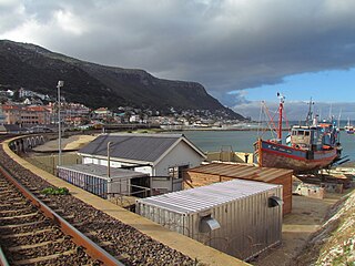
Kalk Bay is a fishing village and suburb of Cape Town. It lies on the east coast of False Bay with much of the town built on the slopes of mountains which border the sea, with peaks of Table Mountain Sandstone forming valleys. The railway from Cape Town to Simon's Town passes through Kalk Bay, which has one station near the harbour.

The Port of Cape Town, South Africa, is situated in Table Bay.

Dorset Island or Cape Dorset Island is one of the Canadian Arctic islands located in Hudson Strait, Nunavut, Canada. It lies off the Foxe Peninsula area of southwestern Baffin Island in the Qikiqtaaluk Region. It is serviced by an airport and a harbour.

Cape Town lies at the south-western corner of the continent of Africa. It is bounded to the south and west by the Atlantic Ocean, and to the north and east by various other municipalities in the Western Cape province of South Africa.
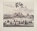
Dozens of fortifications were built in Cape Town and the Cape Peninsula between the 1650s and the 1940s. Most have gone, but a few still stand.

The Table Bay Harbour 0-4-0T of 1874 was a South African steam locomotive from the pre-Union era in the Cape of Good Hope.

The Table Mountain National Park Marine Protected Area is an inshore marine protected area around the Cape Peninsula, in the vicinity of Cape Town, South Africa. It was proclaimed in Government Gazette No. 26431 of 4 June 2004 in terms of the Marine Living Resources Act, 18 of 1998.

Recreational dive sites are specific places that recreational scuba divers go to enjoy the underwater environment or for training purposes. They include technical diving sites beyond the range generally accepted for recreational diving. In this context all diving done for recreational purposes is included. Professional diving tends to be done where the job is, and with the exception of diver training and leading groups of recreational divers, does not generally occur at specific sites chosen for their easy access, pleasant conditions or interesting features.

The following outline is provided as an overview of and topical guide to Cape Town: