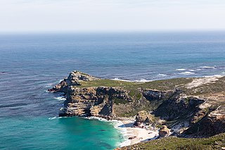
The Cape of Good Hope is a rocky headland on the Atlantic coast of the Cape Peninsula in South Africa.

The African penguin, also known as Cape penguin or South African penguin, is a species of penguin confined to southern African waters. Like all penguins, it is flightless, with a streamlined body and wings stiffened and flattened into flippers for a marine habitat. Adults weigh an average of 2.2–3.5 kg (4.9–7.7 lb) and are 60–70 cm (24–28 in) tall. The species has distinctive pink patches of skin above the eyes and a black facial mask. The body's upper parts are black and sharply delineated from the white underparts, which are spotted and marked with a black band.

The Tasman Peninsula, officially Turrakana / Tasman Peninsula, is a peninsula located in south-east Tasmania, Australia, approximately 75 km (47 mi) by the Arthur Highway, south-east of Hobart.

Plettenberg Bay, nicknamed Plet or Plett, is the primary town of the Bitou Local Municipality in the Western Cape Province of South Africa. As of the census of 2001, there were 29,149 population. It was originally named Bahia Formosa by early Portuguese explorers and lies on South Africa's Garden Route 210 km from Port Elizabeth and about 600 km from Cape Town.

Paternoster is one of the oldest fishing villages on the West Coast of South Africa. It is situated 15 km north-west of Vredenburg and 145 km north of Cape Town, at Cape Columbine between Saldanha Bay and St Helena Bay. The town covers an area of 194.8 hectare and has approximately 1883 inhabitants.
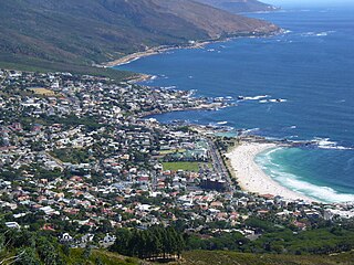
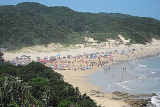
Camps Bay is an affluent suburb of Cape Town, South Africa, and the small bay on the west coast of the Cape Peninsula after which it is named. In summer it attracts many South African and foreign visitors.

Strand is a seaside resort town in the Western Cape, South Africa. It forms part of the Helderberg region of the City of Cape Town Metropolitan Municipality, situated on the north-eastern edge of False Bay and near the foot of the Helderberg Mountains. Its geographical position is between Somerset West and Gordon's Bay, and is about 50 km southeast of Cape Town City Bowl. Strand has a population of approximately 50,000. Strand's main attraction is the beach; 5 km of white sandy beach off False Bay.

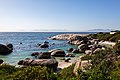
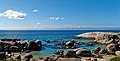
The Cape Peninsula is a generally mountainous peninsula that juts out into the Atlantic Ocean at the south-western extremity of the African continent. At the southern end of the peninsula are Cape Point and the Cape of Good Hope. On the northern end is Table Mountain, overlooking Table Bay and the city bowl of Cape Town, South Africa. The peninsula is 52 km long from Mouille point in the north to Cape Point in the south. The Peninsula has been an island on and off for the past 5 million years, as sea levels fell and rose with the ice age and interglacial global warming cycles of, particularly, the Pleistocene. The last time that the Peninsula was an island was about 1.5 million years ago. Soon afterwards it was joined to the mainland by the emergence from the sea of the sandy area now known as the Cape Flats. The towns and villages of the Cape Peninsula and Cape Flats, and the undeveloped land of the rest of the peninsula now form part of the City of Cape Town metropolitan municipality. The Cape Peninsula is bounded to the north by Table Bay, to the west by the open Atlantic Ocean, and to the east by False Bay in the south and the Cape Flats in the north.

Simon's Town, sometimes spelled Simonstown, is a town in the Western Cape, South Africa and is home to Naval Base Simon's Town, the South African Navy's largest base. It is located on the shores of False Bay, on the eastern side of the Cape Peninsula. For more than two centuries it has been a naval base and harbour. The town is named after Simon van der Stel, an early governor of the Cape Colony.

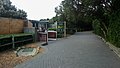
Fish Hoek is a coastal town at the eastern end of the Fish Hoek Valley on the False Bay side of the Cape Peninsula in the Western Cape, South Africa. Previously a separate municipality, Fish Hoek is now part of the City of Cape Town. As a coastal suburb of Cape Town, Fish Hoek is popular as a residence for commuters, retired people and holidaymakers alike. The traditional industries of 'trek' fishing and angling coexist with the leisure pursuits of surfing, although nearby Kommetjie is usually favoured, sailing and sunbathing. There is an active lifeguard community who utilise the beach and bay for training.

False Bay is a body of water in the Atlantic Ocean between the mountainous Cape Peninsula and the Hottentots Holland Mountains in the extreme south-west of South Africa. The mouth of the bay faces south and is demarcated by Cape Point to the west and Cape Hangklip to the east. The north side of the bay is the low-lying Cape Flats, and the east side is the foot of the Hottentots Holland Mountains to Cape Hangklip which is at nearly the same latitude as Cape Point. In plan the bay is approximately square, being roughly the same extent from north to south as east to west, with the southern side open to the ocean. The seabed slopes gradually down from north to south, and is mostly fairly flat unconsolidated sediments. Much of the bay is off the coast of the City of Cape Town, and it includes part of the Table Mountain National Park Marine Protected Area and the whole of the Helderberg Marine Protected Area. The name "False Bay" was applied at least three hundred years ago by sailors returning from the east who confused Cape Point and Cape Hangklip, which are somewhat similar in profile when approached from the southeast.
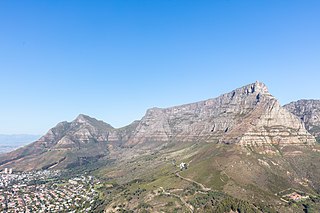
Table Mountain National Park, previously known as the Cape Peninsula National Park, is a national park in Cape Town, South Africa, proclaimed on 29 May 1998, for the purpose of protecting the natural environment of the Table Mountain Chain, and in particular the rare fynbos vegetation. The park is managed by South African National Parks. The property is included as part of the UNESCO Cape Floral Region World Heritage Site.

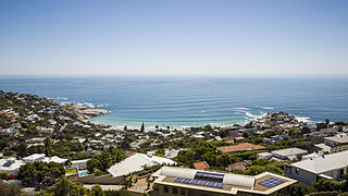
Clifton is an affluent suburb of Cape Town, South Africa. It is an exclusive residential area and is home to the most expensive real estate in South Africa, with dwellings nestled on cliffs that have sweeping views of the Atlantic Ocean.

Helderberg refers to a planning district of the City of Cape Town metropolitan municipality, the mountain after which it is named, a wine-producing area in the Western Cape province of South Africa, or a small census area in Somerset West.
Llandudno is a seaside suburb of Cape Town on the Atlantic seaboard of the Cape Peninsula in the Western Cape, South Africa. There are no street lights, shops or commercial activities, and the town has some of the most expensive residential property in South Africa.

Cape Town lies at the south-western corner of the continent of Africa. It is bounded to the south and west by the Atlantic Ocean, and to the north and east by various other municipalities in the Western Cape province of South Africa.

Miller's Point is a headland and stretch of protected coastline in South Africa. It is located about 4 kilometres (2.5 mi) south of Simon's Town on the road to Cape Point.
Morgan Bay is a village in Amathole District Municipality in the Eastern Cape province of South Africa.

Wright Island is a 1 hectare island in Encounter Bay, South Australia. It is located between the popular tourist destination Granite Island and the prominent rocky headland known as The Bluff. The island consists largely of granite boulders. It also features low vegetation and a sandy beach suitable for the landing of small boats. The island is uninhabited and can only be accessed from the water. It was named after William Wright, one of the headmen of the South Australia Company's whaling operations in the Victor Harbor area in the 1800s. The island is managed by the City of Victor Harbor, the local government authority, as part of its parks and gardens asset.

The Table Mountain National Park Marine Protected Area is an inshore marine protected area around the Cape Peninsula, in the vicinity of Cape Town, South Africa. It was proclaimed in Government Gazette No. 26431 of 4 June 2004 in terms of the Marine Living Resources Act, 18 of 1998.