
Stellenbosch is a town in the Western Cape province of South Africa, situated about 50 kilometres east of Cape Town, along the banks of the Eerste River at the foot of the Stellenbosch Mountain. The town became known as the City of Oaks or Eikestad in Afrikaans and Dutch due to the large number of oak trees that were planted by its founder, Simon van der Stel, to grace the streets and homesteads.

Rondebosch is one of the Southern Suburbs of Cape Town, South Africa. It is primarily a residential suburb, with shopping and business districts as well as the main campus of the University of Cape Town. The area is noted for its beautiful views of Table Mountain, its convent location to the rest of the city of Cape Town, and its proximity to the University of Cape Town.

Heath Town is a suburban area of Wolverhampton, West Midlands, England, to the east of the city centre. It is also a ward of City of Wolverhampton Council. The ward forms part of the Wolverhampton North East parliamentary constituency.

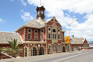
Simon's Town, sometimes spelled Simonstown, is a town in the Western Cape, South Africa and is home to Naval Base Simon's Town, the South African Navy's largest base. It is located on the shores of Simon's Bay in False Bay, on the eastern side of the Cape Peninsula. For more than two centuries it has been a naval base and harbour. The town is named after Simon van der Stel, an early governor of the Cape Colony.
Muizenberg is a beach-side town in the Western Cape, South Africa. It is situated where the shore of the Cape Peninsula curves round to the east on the False Bay coast. It is considered to be the main surfing spot in Cape Town and is currently home to a surfing community, centered on the popular 'Surfer's Corner'.
Kraaifontein is a town in the Western Cape province of South Africa and is located on the north-eastern outskirts of the City of Cape Town Metropolitan Municipality.

Wynberg is a southern suburb of the City of Cape Town in Western Cape, South Africa. It is situated between Plumstead and Kenilworth, and is a main transport hub for the Southern Suburbs of Cape Town.

Cape Town railway station is the main railway station of the city of Cape Town, South Africa. It is located along Adderley and Strand Streets in the city's central business district.

Metrorail Western Cape is a network of commuter and suburban rail services in the City of Cape Town Metropolitan Municipality and in the surrounding towns of Malmesbury, Paarl, Stellenbosch and Wellington in the Western Cape province of South Africa.
The Cuckoo Line is an informal name for the now defunct railway service which linked Polegate and Eridge in East Sussex, England, from 1880 to 1968. It was nicknamed the Cuckoo Line by drivers, from a tradition observed at the annual fair at Heathfield, a station on the route. At the fair, which was held each April, a lady would release a cuckoo from a basket, it being supposedly the 'first cuckoo of spring'. The railway line served the following Sussex communities: Polegate, Hailsham, Hellingly, Horam for Waldron, Heathfield, Mayfield, Rotherfield and Eridge. Services continued through Eridge and onward via Groombridge to Tunbridge Wells.

Rosebank is one of the Southern Suburbs of Cape Town, South Africa, located between the suburbs of Mowbray and Rondebosch.
Kenilworth is a suburb in Cape Town, South Africa.
The Southern Line is a commuter rail line operated by Metrorail Western Cape, connecting Cape Town station in central Cape Town, South Africa with the Southern Suburbs and the towns on the west coast of False Bay, terminating in Simon's Town.

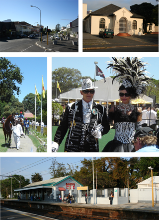
St James is a seaside village on the Cape Peninsula, South Africa, situated on the False Bay coast between Muizenberg and Kalk Bay. The village is situated between the rocky shore and a steep mountain, and measures about 200m by 2 km. Its name derives from the early St James Catholic Church, built circa 1880. Most of the suburb was built between 1910 and 1950, after the railway line was built connecting Cape Town to False Bay.
The Cape Flats Line is a commuter rail line in Cape Town, South Africa, operated by Metrorail Western Cape. It connects central Cape Town with the suburbs of Pinelands, Athlone, Lansdowne, Ottery, Southfield, Healthfield and Retreat.
The Central Line is a commuter rail service in Cape Town, South Africa, operated by Metrorail Western Cape. Central Line services operate along two routes from central Cape Town to Langa, and then along three branches from Langa to various areas in the south-east of the city. The first branch runs to Mitchell's Plain, the second to Khayelitsha, and the third passes through Belhar to terminate in Bellville.
Diep River is a suburb in Cape Town, South Africa, named after the Diep River that runs through the area. The suburb is bordered by Heathfield to the south and Plumstead to the north. Diep River railway station is on the main line from Cape Town to Simon's Town.
Retreat is a suburb in Cape Town, South Africa.
Steenberg is a small community in the Southern Suburbs of Cape Town, South Africa. It has a population of slightly more than 4,000 and mainly includes those belonging to the Cape Coloured community. The main center of the suburb is Military Road, which runs from west connecting Tokai and Kirstenhof at the M4 Main Road and then east into the M5 which provides access to Muizenberg and various other northern suburbs including Bellville and Century City. Military Road has many small businesses lining its south side but also one of South Africa's largest retailers, Shoprite, which has a branch located close to the M5.

The following outline is provided as an overview of and topical guide to Cape Town:

