Strand is often referred to as The Strand (Afrikaans: Die Strand), which is the old name of the town.
The vehicle registration code for Strand is CEY and the postal code for street addresses is 7140.
History
Strand was established as a holiday and fishing resort in 1714.[4] Before being known as Strand, the settlement was known as Mostert's Bay. In 1970, during the Apartheid era, all black, coloured and Asian people were forcefully removed when the town was classified as a white-only resort.[citation needed] Included in the communities forced to leave at this time were the descendants of Cape Malay slaves, who had escaped from Cape Town over 100 years earlier.[5] They lost their homes, but their mosque still stands today.
Strand is administered by the City of Cape Town Metropolitan Municipality. It is in close proximity to the inland town of Somerset West. Recent expansion and development of both towns has resulted in the two now being adjacent to each other, with shopping malls and residential complexes creating the connections. The unofficial divide between the two towns is the national road which bisects them, the N2. Strand forms part of the Helderberg Basin, along with Somerset West and Gordon's Bay.[2]
Strand offers white-sand beaches and views of the Cape Peninsula. During the summer, tourists from other parts of South Africa, including Johannesburg, and abroad, come to enjoy the seaside offerings. Tourism has been a major source of local income since 1950,[citation needed] when the town was popular with visitors from the north of the country, and was home to many retired veterans of the Boer War.[citation needed] There is a train service from Strand to the CBD of Cape Town.
Strand also used to accommodate one of the largest dynamite factories in South Africa, owned by the AECI group. This area is being redeveloped into a large new mixed-use urban development, Paardevlei, and current tenants include Cheetah Outreach.[citation needed]
Tourism
The main beach in the Strand, Melkbaai Beach, is a safe bathing area. Facilities on or nearby this beach include Waterworld with a supertube and mini-golf and Harmony Park which includes a tidal pool. Water sports may be conducted from various points along the beachfront.
Strand also has an Olympic-sized indoor pool which is centrally heated and is open all year round. The coast between the Lourens River mouth and Gordon's Bay is popular with beach fishermen and rock anglers.
Aerial view of Strand on False Bay's shore, with the Hottentots-Holland, Steenbras Dam and Kogelberg beyondSandy beach with tidal pool along the Beach Road in Strand with Gordon's Bay and the Hottentots Holland Mountains in the backgroundA low altitude aerial view of the Strand Beachfront.
Surfing is a popular water sport in Strand, despite the possibility of sharks. These spots are reportedly[by whom?] much easier and safer to surf than other offshore surf spots on the Atlantic Ocean side of the Cape Peninsula, owing to the protection that False Bay offers.[citation needed]
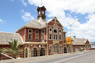
Central business district
The town has a business district attracting customers from the surrounding basin. The CBD offers banks, numerous shopping malls, restaurants, and supermarkets. Friedman & Cohen is the largest single shop in the CBD and serves as a major attraction for residents and visitors. The major shopping malls in the area include the Dorpsmeent Centre, Somerset Mall. The latter is not in the CBD, but outside the town, on the border of Somerset West, next to the N2 road.
Strand's central business district is entirely surrounded by Strand North and Strand South. Strand Beach Road is divided into three sections - the Golden Mile (also known as Melkbaai) is located between Lourens River and Hibernian Towers (cnr. Beach Road and Sarel Cilliers Road), the central part of Beach Road stretches between Sarel Cilliers Road and the Pavilion complex, whilst the Platinum Mile is located along Blakes Beach and between Odeon Towers and the Ocean View Hotel.[citation needed]
Industry
Strand has its industrial areas, mostly spread along the south side of the N2, including Gants Plaza, Broadlands, and a development near Paardevlei. More recently, Gants Plaza has increasingly been accommodating non-industrial businesses, including the local newspaper, the District Mail / Distrikspos.
In winter there may be a low inversion layer covering the town, resulting in some degree of pollution. This is rarely seen, however, because of the prevalent winds that keep Strand's skies clean.[citation needed]
Education
The town has primary, secondary and tertiary education facilities, and many ECD facilities of varying quality. As of 2007, there are 19 public and private schools.
The Strand was a municipality from 1897 to 1996. During that period, it used two coats of arms.
Municipal (1) — The first coat of arms was assumed on 24 February 1927.[6] The shield was divided in two by a vertical line, and displayed a golden sun on a blue background, and a fish on a background of wavy silver and blue stripes; across the top of the shield was a golden stripe bearing three red towers. An anchor was placed behind the shield. The motto was Inspirata floruit.
Municipal (2) — In March 1955, the council approved a new version of the arms, by Ivan Mitford-Barberton. It registered them with the Cape Provincial Administration in August 1955[7] and at the Bureau of Heraldry in October 1993.[8]
The new shield of arms was: Per fess, Azure and barry wavy Argent and Azure, on a fess Gules, between in chief a demi-sun issuant and in base a fish naiant, three towers, Or. In layman's terms, the shield was now divided into three horizontal bands, displaying (1) a golden demi-sun on a blue background, (2) three gold towers on a red background, and (3) a golden fish on a background of wavy silver and blue stripes. A crest consisting of a red anchor on a golden mural crown was added. The motto remained the same.
Cape Town is the legislative capital of South Africa. It is the country's oldest city and the seat of the Parliament of South Africa. It is the country's second-largest city, after Johannesburg, and the largest in the Western Cape. The city is part of the City of Cape Town metropolitan municipality.
Mossel Bay is a harbour town of about 120,000 people on the Southern Cape of South Africa. It is an important tourism and farming region of the Western Cape Province. Mossel Bay lies 400 kilometres east of the country's seat of parliament, Cape Town, and 400 km west of Port Elizabeth, the largest city in the Eastern Cape. The older parts of the town occupy the north-facing side of the Cape St Blaize Peninsula, whilst the newer suburbs straddle the Peninsula and have spread eastwards along the sandy shore of the Bay.
Stellenbosch is a town in the Western Cape province of South Africa, situated about 50 kilometres east of Cape Town, along the banks of the Eerste River at the foot of the Stellenbosch Mountain. The town became known as the City of Oaks or Eikestad in Afrikaans and Dutch due to the large number of oak trees that were planted by its founder, Simon van der Stel, to grace the streets and homesteads.
Uitenhage, officially renamed Kariega, is a South African town in the Eastern Cape Province. It is well known for the Volkswagen factory located there, which is the biggest car factory on the African continent. Along with the city of Port Elizabeth and the small town of Despatch, it forms the Nelson Mandela Bay Metropolitan Municipality.
Kroonstad, officially named Maokeng, is the fourth largest town in the Free State and lies two hours' drive on the N1 from Gauteng. It is the second-largest commercial and urban centre in the Northern Free State, and an important railway junction on the main line from Cape Town to Johannesburg. Maokeng is Sesotho and means "place of the thorn trees ".
Sea Point is an affluent and densely populated suburb of Cape Town, situated between Signal Hill and the Atlantic Ocean, a few kilometres to the west of Cape Town's Central Business District (CBD). Moving from Sea Point to the CBD, one passes first through the small suburb of Three Anchor Bay, then Green Point. Seaward from Green Point is the area known as Mouille Point, where the local lighthouse is situated. It borders to the southwest the suburb of Bantry Bay. It is known for its large Jewish population, synagogues, and kosher food options.
Simon's Town, sometimes spelled Simonstown, is a town in the Western Cape, South Africa and is home to Naval Base Simon's Town, the South African Navy's largest base. It is located on the shores of Simon's Bay in False Bay, on the eastern side of the Cape Peninsula. For more than two centuries it has been a naval base and harbour. The town is named after Simon van der Stel, an early governor of the Cape Colony.
The N2 is a national route in South Africa that runs from Cape Town through George, Gqeberha, East London, Mthatha, Port Shepstone and Durban to Ermelo. It is the main highway along the Indian Ocean coast of the country. Its current length of 2,255 kilometres (1,401 mi) makes it the longest numbered route in South Africa.
Fish Hoek is a coastal town at the eastern end of the Fish Hoek Valley on the False Bay side of the Cape Peninsula in the Western Cape, South Africa. Previously a separate municipality, Fish Hoek is now part of the City of Cape Town. As a coastal suburb of Cape Town, Fish Hoek is popular as a residence for commuters, retired people and holidaymakers alike. The traditional industries of 'trek' fishing and angling coexist with the leisure pursuits of surfing, although nearby Kommetjie is usually favoured, sailing and sunbathing. There is an active lifeguard community who utilise the beach and bay for training.
Muizenberg is a beach-side town in the Western Cape, South Africa. It is situated where the shore of the Cape Peninsula curves round to the east on the False Bay coast. It is considered to be the main surfing spot in Cape Town and is currently home to a surfing community, centered on the popular 'Surfer's Corner'.
Somerset West is a town in the Western Cape, South Africa. Organisationally and administratively it is included in the City of Cape Town metropolitan municipality Eastern Suburbs zone . The vehicle registration code for Somerset West is CFM and the post code is 7130 for street addresses, and 7129 for post office boxes.
Hottentots-Holland High School is an Afrikaans- and English-speaking school in the Western Cape in South Africa, situated between the towns of Somerset West and Strand. The parallel-medium, co-educational school, situated to the northeast of the N2 national road, was opened at its current site by Dr G. G. (Gawie) Cillie, Chairman of the School Board, in February, 1930. A portion of the land on which it now stands having been given by Mesdames Beynon and Osler, daughters of an early Somerset West shopkeeper and property owner. At this time the school had an enrollment of 220 pupils and a staff of 11 under Mr A. J. Ackerman. The school motto "Sibi Fidelis Ipsi" is Latin for "True To Oneself". Prior to 1930, the school operated under the name Somerset West Public School.
Kuils River is a town in the Western Cape, South Africa, 25 km east of Cape Town CBD at the gateway of the Cape Winelands. It is also the name of the main tributary of the Eerste River, and forms part of the Eastern Suburbs zone of the City of Cape Town.
Gordon's Bay is a harbour town in the Western Cape province of South Africa. It is included in the City of Cape Town metropolitan municipality Eastern Suburbs region. It is situated on the shores of Gordon's Bay in the northeastern corner of False Bay about 58 km from Cape Town to the south of the N2 national road and is named after Robert Jacob Gordon (1743–1795), the Dutch explorer of Scottish descent.
Milnerton is a seaside town on Table Bay and is located north of Cape Town in South Africa. It is located 11 kilometres to the north of the city's centre.
Helderberg refers to a planning district of the City of Cape Town metropolitan municipality, the mountain after which it is named, a wine-producing area in the Western Cape province of South Africa, or a small census area in Somerset West.
Parel Vallei High School is a co-ed high school located in Parel Vallei, a suburb of Somerset West, which is in the Western Cape, South Africa.
Somerset Mall is a 69,000 m2 (740,000 sq ft) shopping mall situated alongside the N2 freeway near the towns of Somerset West and Strand, in the Western Cape province of South Africa. The mall comprises 200 stores and 3,955 parking spaces. Its anchors include Woolworths, Pick n Pay, Game, and Edgars. On 15 November 2023, the Pick 'n Pay was upgraded to a Hypermarket, thereby becoming the 22nd Hypermarket within the group.
False Bay High School is a private school in the Strand of the Western Cape province of South Africa, founded by Herman and Lisa Janse van Rensburg in January 1999. It was originally established in Somerset West but later moved to its current permanent location in the Strand.
The following outline is provided as an overview of and topical guide to Cape Town:
This page is based on this Wikipedia article Text is available under the CC BY-SA 4.0 license; additional terms may apply. Images, videos and audio are available under their respective licenses.


