
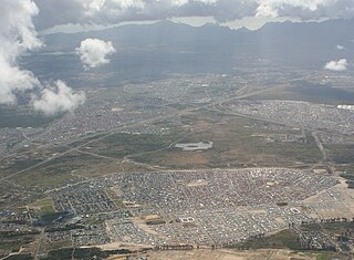
The Cape Flats is an expansive, low-lying, flat area situated to the southeast of the central business district of Cape Town. The Cape Flats is also the name of an administrative region of the City of Cape Town, which lies within the larger geographical area.

East London is a city on the southeastern coast of South Africa, in the Buffalo City Metropolitan Municipality, Eastern Cape Province. The city lies on the Indian Ocean coast, largely between the Buffalo River and the Nahoon River, and hosts the country's only river port. As of 2011, East London had a population of over 267,000 with over 755,000 in the surrounding metropolitan area.

District Six is a former inner-city residential area in Cape Town, South Africa. In 1966, the apartheid government announced that the area would be razed and rebuilt as a "whites only" neighbourhood under the Group Areas Act. Over the course of a decade, over 60,000 of its inhabitants were forcibly removed and in 1970 the area was renamed Zonnebloem, a name that makes reference to an 18th century colonial farm. At the time of the proclamation, 56% of the district’s property was White-owned, 26% Coloured-owned and 18% Indian-owned. Most of the residents were Cape Coloureds and they were resettled in the Cape Flats. The vision of a new white neighbourhood was not realised and the land has mostly remained barren and unoccupied. The original area of District Six is now partly divided between the suburbs of Walmer Estate, Zonnebloem, and Lower Vrede, while the rest is generally undeveloped land.

The Kaapse Klopse, formerly known as the Coon Carnival and officially called Cape Town Minstrel Carnival, is a Cape coloured minstrel festival that takes place annually on 2 January in Cape Town, South Africa. It is also referred to as Tweede Nuwe jaar. As many as 13,000 minstrels take to the streets garbed in bright colours, either carrying colourful umbrellas or playing an array of musical instruments. The minstrels are self-organised into klopse. The custom has been preserved since the mid-19th century.

Khayelitsha is a township in Western Cape, South Africa, on the Cape Flats in the City of Cape Town Metropolitan Municipality. The name is Xhosa for New Home. It is reputed to be one of the largest and fastest-growing townships in South Africa.

Langa is a township in Cape Town, South Africa. Its name in Xhosa means "sun". The township was initially built in phases before being formally opened in 1927. It was developed as a result of South Africa's 1923 Urban Areas Act, which was designed to force Africans to move from their homes into segregated locations. Similar to Nyanga, Langa is one of the many areas in South Africa that were designated for Black Africans before the apartheid era. It is the oldest of such suburbs in Cape Town and was the location of much resistance to apartheid.
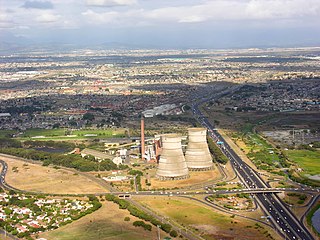
Athlone is a suburb of Cape Town located to the east of the city centre on the Cape Flats, south of the N2 highway. Two of the suburb's main landmarks are Athlone Stadium and the decommissioned coal-burning Athlone Power Station. Athlone is mainly residential and is served by a railway station of the same name. It however includes industrial and commercial zones. There are many "sub-areas" within Athlone, including Gatesville, Rylands, Belgravia Estate, Bridgetown and Hazendal. Colloquially other areas around Athlone are also often included in the greater Athlone area even though the City of Cape Town might classify them as separate neighborhoods such as Rondebosch East, Crawford, and Manenberg.

Gugulethu is a township in the Western Cape, South Africa and is 15 km from Cape Town. Its name is a contraction of igugu lethu, which is Xhosa for our pride. The township was established along with Nyanga in the 1960s.

Mitchells Plain is a large census designated sub-place located within the City of Cape Town, Western Cape, South Africa and situated about 28 km (17 mi) from the Cape Town city centre. It is one of South Africa's largest residential areas and contains multiple smaller suburbs. It is located on the Cape Flats on the False Bay coast between Muizenberg and Khayelitsha. Conceived of as a "model suburb" by the apartheid government, it was built during the 1970s to provide housing for Coloured victims of forced removal due to the implementation of the Group Areas Act.
Mfuleni is a relatively new township about 32 kilometres from central Cape Town, South Africa. It is a predominantly Black township, although there are also some Coloured members of the community.

Nyanga is a township in the Western Cape, South Africa. Its name in Xhosa means "moon" and it is one of the oldest black townships in Cape Town. It was established as a result of the migrant labour system. In 1948 black migrants were forced to settle in Nyanga as Langa had become too small. Nyanga was one of the poorest places in Cape Town and is still one of the most dangerous parts of Cape Town. In 2001 its unemployment rate was estimated at being approximately 56% and HIV/AIDS is a huge community issue.
Lwandle/Nomzamo is a small township in the Helderberg basin just outside Strand in the Western Cape of South Africa. Both names are sometimes used interchangeably referring to both places. This may be attributed to the fact that Nomzamo was born as a result of overpopulation in Lwandle area which initially designed as a cheap accommodation for "single male workers" during the apartheid years.

Crossroads is a high-density township in the Western Cape, South Africa.

The Western Cape Anti-Eviction Campaign was a non-racial popular movement made up of poor and oppressed communities in Cape Town, South Africa. It was formed in November 2000 with the aim of fighting evictions, water cut-offs and poor health services, obtaining free electricity, securing decent housing, and opposing police brutality.

Philippi is a large urban and semi-urban area in Cape Town's Cape Flats region, in the Western Cape, South Africa. It comprises the Philippi Horticultural Area to the west, and the neighbourhoods of Brown's Farm, Philippi East and Samora Machel located within its eastern half. The neighbourhoods of Gugulethu and Nyanga are located to its north. The horticultural area is sparsely populated compared to the surrounding city and contains many farms.
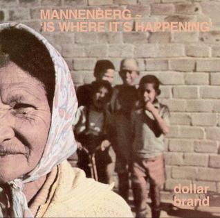
"Mannenberg" is a Cape jazz song by South African musician Abdullah Ibrahim, first recorded in 1974. Driven into exile by the apartheid government, Ibrahim had been living in Europe and the United States during the 1960s and '70s, making brief visits to South Africa to record music. After a successful 1974 collaboration with producer Rashid Vally and a band that included Basil Coetzee and Robbie Jansen, Ibrahim began to record another album with these three collaborators and a backing band assembled by Coetzee. The song was recorded during a session of improvisation, and includes a saxophone solo by Coetzee, which led to him receiving the sobriquet "Manenberg".

Gladys Nomfanekiso Mgudlandlu was a South African artist and educator. Noted as one of the first African women in South Africa to hold a solo exhibition, she was a pioneer in visual arts in her country, for which she was given the Presidential Order of Ikhamanga in Silver. She drew influences from her cultural background and the landscape around her.
Fezeka High School is a public high school located in Gugulethu, Western Cape, South Africa. It is one of the high schools in the City of Cape Town Metropolitan Municipality.
The history of gangs in South Africa goes back to the Apartheid era.
The 1999 Manenberg tornado was a rare tornado that occurred in the Cape Town neighborhood of Manenberg, South Africa killing five people on the night of 29 August 1999. Wind speeds were recorded reaching over 150 km per hour. The tornado killed five people and injured an additional 220. Over 5,000 residents were left homeless with 40 flats being "totally gutted". R1 million was allocated by City of Cape Town's disaster relief fund for rebuilding.


