External links
34°1′24″S18°19′51″E / 34.02333°S 18.33083°E
Sandy Bay is a nudist beach just south of Llandudno. It is on the west side of the Karbonkelberg, and cannot be seen from the main road to Hout Bay, which turns inland above Llandudno.
Sandy Bay is not easily accessible. There are two ways to get the beach, one can clamber over the rocks from the car park at the southern end of Llandudno or take a 20-minute walk from the car park at the northern end of Hout Bay. The car parks are rather small and parking is often insufficient – the only solution is getting there early or having to walk a little further. [1]
34°1′24″S18°19′51″E / 34.02333°S 18.33083°E

Cape Town is the legislative capital of South Africa. It is the country's oldest city and the seat of the Parliament of South Africa. It is the country's second-largest city, after Johannesburg, and the largest in the Western Cape. The city is part of the City of Cape Town metropolitan municipality.
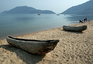
Monkey Bay or Lusumbwe is a town in Mangochi which is in the Mangochi District in the Southern Region of Malawi. The town is on the shore of Lake Malawi and is one of the main ports on Lake Malawi. The population of Monkey Bay was 14,955 according to the 2018 census. Monkey Bay is 206 kilometres (128 mi) from Lilongwe, Malawi's capital city, and 253 kilometres (157 mi) from Blantyre. Monkey Bay is a tourist resort and is often travelled through on the road to Cape Maclear.

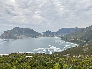
The Cape Peninsula is a generally mountainous peninsula that juts out into the Atlantic Ocean at the south-western extremity of the African continent. At the southern end of the peninsula are Cape Point and the Cape of Good Hope. On the northern end is Table Mountain, overlooking Table Bay and the City Bowl of Cape Town, South Africa. The peninsula is 52 km long from Mouille point in the north to Cape Point in the south. The Peninsula has been an island on and off for the past 5 million years, as sea levels fell and rose with the ice age and interglacial global warming cycles of, particularly, the Pleistocene. The last time that the Peninsula was an island was about 1.5 million years ago. Soon afterwards it was joined to the mainland by the emergence from the sea of the sandy area now known as the Cape Flats. The towns and villages of the Cape Peninsula and Cape Flats, and the undeveloped land of the rest of the peninsula now form part of the City of Cape Town metropolitan municipality. The Cape Peninsula is bounded to the north by Table Bay, to the west by the open Atlantic Ocean, and to the east by False Bay in the south and the Cape Flats in the north.

False Bay is a body of water in the Atlantic Ocean between the mountainous Cape Peninsula and the Hottentots Holland Mountains in the extreme south-west of South Africa. The mouth of the bay faces south and is demarcated by Cape Point to the west and Cape Hangklip to the east. The north side of the bay is the low-lying Cape Flats, and the east side is the foot of the Hottentots Holland Mountains to Cape Hangklip which is at nearly the same latitude as Cape Point. In plan the bay is approximately square, being roughly the same extent from north to south as east to west, with the southern side open to the ocean. The seabed slopes gradually down from north to south, and is mostly fairly flat unconsolidated sediments. Much of the bay is off the coast of the City of Cape Town, and it includes part of the Table Mountain National Park Marine Protected Area and the whole of the Helderberg Marine Protected Area. The name "False Bay" was applied at least three hundred years ago by sailors returning from the east who confused Cape Point and Cape Hangklip, which are somewhat similar in profile when approached from the southeast.
Hout Bay is a seaside suburb of Cape Town in the Western Cape province of South Africa. It is situated in a valley on the Atlantic seaboard of the Cape Peninsula, twenty kilometres south of the Central business district of Cape Town. The name "Hout Bay" can refer to the town, the bay on which it is situated, or the entire valley.

Noordhoek is a seaside town in the Western Cape, South Africa, located below Chapman's Peak on the west coast of the Cape Peninsula and is approximately 35 kilometres (22 mi) to the south of Cape Town. The name "Noordhoek" was taken from Dutch and literally means "north corner". It was given this name in 1743 as being the northern corner of the Slangkop farm. The first permanent resident of European origin is Jaco Malan who built his house there. In 1857, the region was divided into six plots, most of which were bought by a single family, that of the de Villiers. Noordhoek nevertheless remains a predominantly rural area where farmers grow vegetables to supply ships calling at Simon's Town. It is best known for its shoreline and its long, wide, sandy beach, which stretches south to the neighbouring village of Kommetjie. Near the southern end of this beach is the wreck of the steamship "Kakapo", which ran aground in 1900, when the captain mistook Chapman's Peak for the Cape of Good Hope and put the helm over to port.
The Cape Metropole has a wide variety of beaches divided into three regions by the Cape Peninsula:
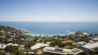
Llandudno is a seaside suburb of Cape Town on the Atlantic seaboard of the Cape Peninsula in the Western Cape, South Africa. There are no street lights, shops or commercial activities, and the town has some of the most expensive residential property in South Africa.
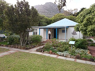
Hout Bay Museum is a province-aided museum at 4 Andrews Road in Hout Bay near Cape Town, South Africa. Opened on 5 April 1979, the museum has displays on the history of the Hout Bay valley and its people, focusing on forestry, mining, and the fishing industry up to modern times. The museum also organises weekly guided nature walks into the surrounding mountains. The first curator at Hout Bay Museum was Pam Wormser.

Cape Maclear or Chembe is a town in the Mangochi District of Malawi's Southern Region. The town, on the Nankumba Peninsula, is on the southern shore of Lake Malawi and is the busiest resort on Lake Malawi. Cape Maclear is close to the islands of Domwe, Thumbwe and Mumbo Island on Lake Malawi, and is in Lake Malawi National Park.

Tourism in Namibia is a major industry, contributing N$7.2 billion to the country's gross domestic product. Annually, over one million travelers visit Namibia, with roughly one in three coming from South Africa, then Germany and finally the United Kingdom, Italy and France. The country is among the prime destinations in Africa and is known for ecotourism which features Namibia's extensive wildlife.
Fine Music Radio is a radio station that is based within the Artscape Theatre Centre in Cape Town, South Africa. Founded in 1995, Fine Music Radio focuses mainly on classical music and jazz, and broadcasts on frequencies 101.3 in the greater Cape Town area - 107.9 in Noordhoek and Fish Hoek - 94.7 in Hout Bay and Llandudno - 97.1 on the Atlantic seaboard. The station also live streams its programming.
Umhlanga lagoon is a 26 hectares nature reserve on the shore of the Indian Ocean at Umhlanga Rocks, South Africa. The reserve encloses the Ohlanga River's lagoon and mouth. The forest forms a natural extension of the less accessible Hawaan Forest, of which the greater part lies inland of the busy M4 road. The reserve trails start at a car park at the northern end of Lagoon Drive, Umhlanga.

Bakoven is a small residential suburb on the west coast of the Cape Peninsula, in the southwest of Camps Bay.

The Table Mountain National Park Marine Protected Area is an inshore marine protected area around the Cape Peninsula, in the vicinity of Cape Town, South Africa. It was proclaimed in Government Gazette No. 26431 of 4 June 2004 in terms of the Marine Living Resources Act, 18 of 1998.

The following outline is provided as an overview of and topical guide to Cape Town:
The Twelve Apostles are part of the Table Mountain complex overlooking Camps Bay in Cape Town, South Africa. The mountain range stretches 6 km almost to Hout Bay. They actually consist of eighteen peaks. From north to south they are named Kloof, Fountain, Porcupine, Jubilee, Barrier, Valken, Kasteel, Postern, Wood, Spring, Slangolie, Corridor, Separation, Victoria, Grove, Llandudno Peak, Llandudno Corridor, and Hout Bay Corner. The average height above sea level is 750 m, compared to 1,060 m for Table Mountain. Under the Dutch East India Company, the range was known as the Castle Mountains or Gable Mountains.