
Bloemfontein, also known as Bloem, is one of South Africa's three capital cities and the capital of the Free State province. It serves as the country's judicial capital, along with legislative capital Cape Town and administrative capital Pretoria. Bloemfontein is the seventh-largest city in South Africa.
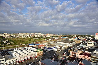
East London is a city on the southeast coast of South Africa in the Buffalo City Metropolitan Municipality of the Eastern Cape province. The city lies on the Indian Ocean coast, largely between the Buffalo River and the Nahoon River, and hosts the country's only river port. As of 2011, East London had a population of over 267,000 with over 755,000 in the metropolitan area.
Pietermaritzburg is the capital and second-largest city in the province of KwaZulu-Natal, South Africa. It was founded in 1838 and is currently governed by the Msunduzi Local Municipality. Its Zulu name umGungundlovu is the name used for the district municipality. Pietermaritzburg is popularly called Maritzburg in Afrikaans, English and Zulu alike, and often informally abbreviated to PMB. It is a regionally important industrial hub, producing aluminium, timber and dairy products, as well as the main economic hub of Umgungundlovu District Municipality. The public sector is a major employer in the city due to local, district and provincial governments located here.

Rondebosch is one of the Southern Suburbs of Cape Town, South Africa. It is primarily a residential suburb, with shopping and business districts as well as the main campus of the University of Cape Town.

Uitenhage, officially renamed Kariega, is a South African town in the Eastern Cape Province. It is well known for the Volkswagen factory located there, which is the biggest car factory on the African continent. Along with the city of Port Elizabeth and the small town of Despatch, it forms the Nelson Mandela Metropolitan Municipality.

District Six is a former inner-city residential area in Cape Town, South Africa. Over 60,000 of its inhabitants were forcibly removed during the 1970s by the apartheid regime.
Athlone is a suburb of Cape Town located to the east of the city centre on the Cape Flats, south of the N2 highway. Two of the suburb's main landmarks are Athlone Stadium and the decommissioned coal-burning Athlone Power Station. Athlone is mainly residential and is served by a railway station of the same name. It however includes industrial and commercial zones. There are many "sub-areas" within Athlone, including Gatesville, Rylands, Belgravia Estate, Bridgetown and Hazendal. Colloquially other areas around Athlone are also often included in the greater Athlone area even though the City of Cape Town might classify them as separate neighborhoods such as Rondebosch East, Crawford, and Manenberg.

Mitchells Plain is a large township located within the City of Cape Town, Western Cape, South Africa and situated about 28 km (17 mi) from the Cape Town city centre. It is one of South Africa's largest residential areas and contains multiple smaller suburbs. It is located on the Cape Flats on the False Bay coast between Muizenberg and Khayelitsha. Conceived of as a "model suburb" by the apartheid government, it was built during the 1970s to provide housing for Coloured victims of forced removal due to the implementation of the Group Areas Act.

Newlands (Nuweland) is an upmarket suburb of Cape Town, South Africa. It is located at the foot of Table Mountain in the Southern Suburbs of Cape Town, and is the wettest suburb in South Africa due to its high winter rainfall. The neighborhood of Bishopscourt is situated to its south west, Claremont to its south east, and Rondebosch to its east and north east.

The Southern Suburbs are a group of suburbs in Cape Town, Western Cape, South Africa. This group includes, among others, Observatory, Mowbray, Pinelands, Thornton, Rosebank, Rondebosch, Rondebosch East, Newlands, Claremont, Lansdowne, Kenilworth, Bishopscourt, Constantia, Wynberg, Ottery, Plumstead, Diep River, Bergvliet and Tokai.
Claremont is a suburb of Cape Town, South Africa. It is situated six miles south of the city, and is one of the so-called "Southern Suburbs", it is situated alongside Lansdowne. It is an important commercial and residential area, which is currently experiencing significant growth and development.

Alexander Sinton Secondary School, also known as Alexander Sinton High School, is an English-medium school in Athlone, a suburb of Cape Town, South Africa. The school is located in the Cape Flats, an area designated as non-white under the Group Areas Act during apartheid. The school was involved in the anti-apartheid student uprisings of the 1970s and 1980s. Staff and students at the school made headlines when they barricaded the police into their school in September 1985. The following month, three youths were killed near the school by police officers who opened fire on protesters in the Trojan Horse Incident. It was the first school to be visited by Nelson Mandela after his release from prison. As of 2014, the school has 1,100 pupils, half boys and half girls. The school employs 40 teachers and six non-teaching staff.

Heideveld is a town or suburb in the Athlone part of Cape Town, South Africa. Its name means "heath-field".

The Maynardville Open-Air Theater is an outdoor theatre in Maynardville Park, Wynberg, Cape Town, South Africa. It seats 720 people and is known for its annual Shakespeare in the Park plays.
Rondebosch East is a residential suburb of Cape Town, South Africa, about 7 kilometres (4.3 mi) south-east of the city centre. As the name suggests, it is located to the east of the neighbouring suburb of Rondebosch. As of 2001 it had a population of approximately 4,600 people in an area of just over 1 square kilometre (0.4 sq mi).

Ottery is a suburb in Cape Town, South Africa. It is on the edge of the Southern Suburbs. The Youngsfield Military Base, Royal Cape Golf Club and Cape Town's 'official' China Town are located in the suburb. Every year the Youngsfield Military Base in Ottery hosts the Cape Argus Junior Cycle Tour on 12 March.
Lansdowne is a suburb in Cape Town, South Africa. situated 10 kilometres southeast of Cape Town City Centre, surrounded by the suburbs of Rondebosch East, Crawford, Wetton, Claremont, Kenwyn and Athlone. Lansdowne is served by a railway station of the same name, on the Cape Flats Line.
The following is a timeline of the history of Cape Town in the Western Cape province of South Africa.
The following is a timeline of the history of Gqeberha in the Nelson Mandela Bay Municipality, Eastern Cape province, South Africa.

The following outline is provided as an overview of and topical guide to Cape Town:


