
The Cape Flats is an expansive, low-lying, flat area situated to the southeast of the central business district of Cape Town. The Cape Flats is also the name of an administrative region of the City of Cape Town, which lies within the larger geographical area.

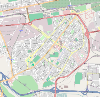
Bellville is a town and former independent city that is now incorporated into the City of Cape Town Metropolitan Municipality in the Western Cape province of South Africa. The town is an industrial and commercial node, a university town, and a major transportation hub within the Greater Cape Town metropolitan area.
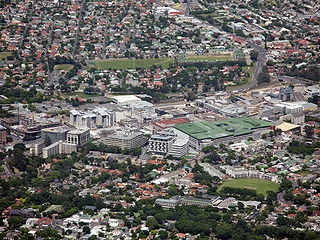
Mill Park is a suburb of Melbourne, Victoria, Australia, 18 km north-east of Melbourne's central business district, located within the City of Whittlesea local government area. Mill Park recorded a population of 28,712 at the 2021 census.

Kloof is a town that includes a smaller area called Everton, located approximately 26 km north-west of Durban in KwaZulu-Natal, South Africa. Once an independent municipality, it now forms part of greater Durban area of the eThekwini Metropolitan Municipality.

Wollaton is a suburb and former civil parish in the western part of Nottingham, in the Nottingham district, in the ceremonial county of Nottinghamshire, England. Wollaton has two wards in the City of Nottingham, with a total population of 24,693 at the 2011 census. It is home to Wollaton Hall, with its museum, deer park, lake, walks and golf course.
Pinelands is an affluent garden city suburb located on the edge of the southern suburbs of Cape Town, South Africa, neighbouring the suburb of Thornton, and is known for its large thatched houses and green spaces. The suburb is primarily residential and is often praised for its peacefulness and abundance of trees. Pinelands is one of the few areas in Cape Town in which sale of alcohol to the public is prohibited, but some clubs have private liquor licenses. It is a popular place for senior citizens to retire to. While there are several retirement homes in the suburb, younger people are increasingly moving in.

Kingsley is a suburb of Perth, Western Australia, located within the City of Joondalup. Kingsley is bounded to the north by Whitfords Avenue, to the south by Hepburn Avenue, to the west by the Mitchell Freeway and to the east by Wanneroo Road.

Wynberg is a southern suburb of the City of Cape Town in Western Cape, South Africa. It is situated between Plumstead and Kenilworth, and is a main transport hub for the Southern Suburbs of Cape Town.

The Rondevlei Nature Reserve is located in Grassy Park, Zeekoevlei and Lavenderhill, suburbs of Cape Town, South Africa. The bird sanctuary covers approximately 290 hectares of mostly permanent wetland and consists of a single large brackish lagoon. The nature reserve is among the most important wetlands for birds in South Africa despite being situated directly alongside the Zeekoevlei. A number of islands on the vlei act as vital breeding sites. Rondevlei is home to about 230 bird species, a variety of small mammals and reptiles like caracal, porcupine, Cape fox, grysbuck, steenbuck and mongoose, as well as a hippopotamus population which was re-introduced in 1981 as a means to control an alien grass species from South America, which had covered the shoreline and was threatening to engulf the vlei itself. It boasts unusual and threatened ecosystems like strandveld, sand plains fynbos, Cape lowland wetland vegetation and indigenous coastal fynbos vegetation with unique plants found nowhere else in the world.

Mitchells Plain is a large census designated sub-place located within the City of Cape Town, Western Cape, South Africa and situated about 28 km (17 mi) from the Cape Town city centre. It is one of South Africa's largest residential areas and contains multiple smaller suburbs. It is located on the Cape Flats on the False Bay coast between Muizenberg and Khayelitsha. Conceived of as a "model suburb" by the apartheid government, it was built during the 1970s to provide housing for Coloured victims of forced removal due to the implementation of the Group Areas Act.

Durbanville, previously called Pampoenkraal, is a town in the Western Cape province of South Africa, part of the greater Cape Town metropolitan area. It is a semi-rural residential suburb on the north-eastern outskirts of the metropolis surrounded by farms producing wine and wheat.
Claremont is a suburb of Cape Town, South Africa. It is situated 9 kilometres south of the city, and is one of the so-called "Southern Suburbs", it is situated alongside Lansdowne. It is an important commercial and residential area, which is currently experiencing significant growth and development.
Belmont is an outer suburb in the City of Brisbane, Queensland, Australia. In the 2016 census, Belmont had a population of 4,374 people.

Gumdale is an outer suburb of the City of Brisbane, Queensland, Australia. In the 2016 census, Gumdale had a population of 2,118 people.

Lota is an eastern bayside suburb in the City of Brisbane, Queensland, Australia. In the 2021 census, Lota had a population of 3,518 people.
Gardens is an affluent inner-city suburb of Cape Town located just to the south of the city centre located in the higher elevations of the "City Bowl" and directly beneath Table Mountain and Lion's Head. It is home to several national museums such as Iziko South African National Gallery and the Iziko South African Museum. The University of Cape Town also houses its Fine Arts department in the suburb, at Michaelis School of Fine Art. Company's Garden, South Africa's oldest garden, a public park and heritage site is a focal point of the suburb. The area is also home to the oldest synagogue in Southern Africa, the Old Shul and its successor, the Gardens Shul, "The Mother Synagogue of South Africa."

Narangba is a town and suburb of the City of Moreton Bay, Queensland, Australia. It is located 34 kilometres (21 mi) north of Brisbane CBD. This suburb has rural origins, but is being redeveloped as a residential suburb on the outskirts of the greater Brisbane metropolitan area. In the 2021 census, Narangba had a population of 20,910 people.
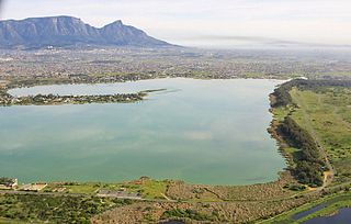
Zeekoevlei is a freshwater lake on the Cape Flats in Cape Town, South Africa. The lake is 258 hectares in area. Its name means hippopotamus pond or lake, from the Afrikaans words seekoei and vlei.

Ottery is a suburb in Cape Town, South Africa. It is on the edge of the Southern Suburbs. The Youngsfield Military Base, Royal Cape Golf Club and Cape Town's 'official' China Town are located in the suburb. Every year the Youngsfield Military Base in Ottery hosts the Cape Argus Junior Cycle Tour on 12 March. The name was derived off the Otter sanctuary which was opened here in the early 1900's, but was closed down as the neighbourhood rapidly expanded later in the century.
Lansdowne is a suburb in Cape Town, South Africa. situated 10 kilometres southeast of Cape Town City Centre, surrounded by the suburbs of Rondebosch East, Crawford, Wetton, Claremont, Kenwyn and Athlone. Lansdowne is served by a railway station of the same name, on the Cape Flats Line.

