Observatory, Cape Town

Last updated

Observatory
Observetory CT.png
Top: One of the historic buildings at the former Royal Observatory, Cape of Good Hope. Middle left: Groote Schuur Hospital. Centre Middle: A World War I monument. Middle right: Cafes on lower main road in Observatory. Bottom: Observatory's soccer and hockey stadium looking towards Devil's Peak.
Observatory, Cape Town
Street map of Observatory
Coordinates: 33°56′16″S18°28′15″E / 33.93778°S 18.47083°E / -33.93778; 18.47083
Country South Africa
Province Western Cape
Municipality City of Cape Town
Government
   Councillor Yusuf Mohamed (DA)
Area
[1]
  Total3.10 km2 (1.20 sq mi)
Elevation
21 m (69 ft)
Population
 (2011) [1]
  Total9,207
  Density3,000/km2 (7,700/sq mi)
Racial makeup (2011)
[1]
   Black African 39.7%
   Coloured 18.5%
   Indian/Asian 3.6%
   White 34.4%
  Other3.9%
First languages (2011)
[1]
   English 66.2%
   Afrikaans 11.2%
   Xhosa 5.9%
   Zulu 1.4%
  Other15.4%
Time zone UTC+2 (SAST)
Postal code (street)
7925
PO box
7935

Observatory is a suburb in Cape Town, South Africa, colloquially known as Obs. [2] Bordered by Mowbray to the south and Salt River to the northwest, the area is best known as a student neighbourhood associated with the nearby University of Cape Town and Groote Schuur Hospital. It takes its name from the South African Astronomical Observatory headquarters, built in 1829 by the Royal Observatory. [3]

Contents

Geography

Observatory is situated on the north-facing lower slopes of Devil's Peak. The slope runs into the Liesbeeck River and, as such, much of present-day lower Observatory was a marshy estuary formed by the rivers, where buffalo, hippo, elephant, zebra, jackals, antelope, lions and leopards were once prevalent. [3]

The Raapenberg Bird Sanctuary protects 10 hectares (25 acres) of land along the Liesbeek River.

History

Lower Main Road, Observatory around the year 1900. Observetory 1900 lower main road.jpg
Lower Main Road, Observatory around the year 1900.

In 1510, the area was the scene of a raid by the Portuguese, led by Francisco de Almeida, on a Goringhaiqua Khoikhoi village, which ultimately led to the death of de Almeida and approximately sixty of his compatriots during the Battle of Salt River. [4]

Modern-day Observatory traces its origins to the Koornhoop Colony land grant issued in 1657. [5] Between February 1657 and February 1658, fourteen free burghers were granted land by the Dutch East India Company along the Liesbeeck River valley. The then governor of the Cape, Jan van Riebeek, decreed that a fortified building called "Fort Coornhoop" be built as one of several small forts to protect against the Khoikhoi. Part of what was developed as Koornhoop became Uitwyk, which is now known as Malta Farm. [6]

The name is derived from the location and construction of the Royal Observatory, Cape of Good Hope [7] in the area at 33°56′7.13″S18°28′38.47″E / 33.9353139°S 18.4773528°E / -33.9353139; 18.4773528 (SAAO) in 1820. [7] The Royal Observatory in Observatory, Cape Town, houses the McClean Telescope. The building was designed by Sir Herbert Baker and was completed in 1897. The original buildings now serve as the headquarters of the South African Astronomical Observatory, with an on-site museum exhibiting various historic instruments and telescopes.

Heidelberg Tavern massacre

McClean Observatory Cape Town McClean Observatory Cape Town.jpg
McClean Observatory Cape Town

During the years of apartheid, Observatory was one of the few de facto 'grey' suburbs where all races lived together. On the evening of 30 December 1993, three men entered a popular student venue on Station Road, called the Heidelberg Tavern and opened fire, killing four people and injuring five. The three APLA operatives – Humphrey Luyanda Gqomfa, Vuyisile Brian Madasi and Zola Prince Mabala – were convicted in November 1994 [8] for what became known as the Heidelberg Massacre. On 16 July 1998, the Truth and Reconciliation Commission granted the three amnesty. [9]

Modern Observatory

It continues to be a somewhat alternative part of town, with 'New Age' stores including an anarchist store, [10] and several programmes at the Observatory Community Centre. It is served by Observatory railway station on the Southern Line, with regular trains every 40 minutes or so, and every hour on Sunday. [11]

Observatory is the location for much of the short-term accommodation used by increasing numbers of international students attending UCT. [12]

Amenities

The suburb's proximity to the University of Cape Town (UCT) and its medical school in particular, has always made it popular with both students and faculty. Observatory has long been a vibrant area, as a result of its high proportion of students. There are numerous restaurants and bars, and many neighbourhood staples. Most restaurants and retail shops are located along Lower Main road with a 95-year-old bottle store, Observatory Liquors, situated in the middle. There is also a shopping complex in St. Peter's square, which is located opposite Groote Schuur graveyard.

Observatory is home to many churches. The Anglican parish church of St Michael and All Angels, designed by Sir Herbert Baker and the only one of his churches completed to his design, is a bastion of Anglo-Catholicism within the Anglican community of South Africa and has a strong choral tradition.

Observatory has a soccer and hockey stadium below the station, Hartleyvale Stadium which is flanked on one side by Liesbeeck Parkway and on the other by Willow Road. In this section of land, there is also an outdoor swimming pool that is popular on summer afternoons – between the two there's a circus school. A driving range and nine-hole golf course is housed at the River Club.

Civic involvement

There are several civic organisations in the suburb. The longest serving is the Observatory Civics Association (OCA) that liaises between the local residents, NGOs, businesses and the City of Cape Town. The Observatory Civics Association is a member of the Greater Cape Town Civic Alliance. [13] The OCA worked with the City of Cape Town to upgrade the Village Green and relocate the World War II memorial from the N2.

In November 2009, the Observatory Improvement District was launched to enhance the suburb with better security and maintenance. The Observatory Improvement District covers almost all of Observatory below Main Road. [14] In 2010, walking and cycle paths were established on the western side of the Liesbeek River.

There are two birdwatching hides on the river, one in the grounds of the South African Observatory, and one in the grounds of the River Club.

Hospitals

Beyond the astronomical observatory is Valkenberg psychiatric hospital, a Victorian heritage building [15] that has recently undergone extensive renovations. Valkenberg houses the mentally ill in secure accommodation, as well as providing out patient care. Beyond Valkenberg is a small hotel, and the Wild Fig restaurant.

The Groote Schuur Hospital looms over the suburb, and is the hospital where Professor Chris Barnard performed the world's first heart transplant, on 3 December 1967. This event is the theme of the Heart of Cape Town Museum, located at the hospital.

Crime and security

As with most of South African urban spaces, crime is a problem, with burglary and muggings. In the past decade there were several murders, however security has now improved with active local civic participation. A pioneering community security organisation, Obs Watch, ran bicycle patrols for years, but became defunct. In 2006 this was formally replaced by the Observatory Neighbourhood Watch, and this intervention has made a significant impact on cleansing and safety in the suburb. [16] Large CCTV cameras have been erected at most of the exits and entrances to Obs.

Controversy

In 2021, Amazon announced that it would be the main tenant and investor in a 15 hectares (37 acres) site in Cape Town along the Salt, Black and Liesbeek Rivers that is being turned into an expansive complex with residences, shops, a hotel, conference centre and a business park. [17] It is expected to become the African headquarters for Amazon, which hopes to base its expanding operations in Africa. However, in May 2022, a court in Cape Town upheld a judgment in March which stopped work on the sprawling complex until further consultations had taken place with groups representing Indigenous Khoisan communities, who object to building on a site they consider sacred. [18] Construction is currently halted due to fears of displacement, as well as concerns over Amazon's business practices. [19]

Related Research Articles

<span class="mw-page-title-main">Groote Schuur Hospital</span> Teaching hospital in Cape Town, Western Cape, South Africa

Groote Schuur Hospital is a large, government-funded, teaching hospital situated on the slopes of Devil's Peak in the city of Cape Town, South Africa. It was founded in 1938 and is famous for being the institution where the first human-to-human heart transplant took place, conducted by University of Cape Town-educated surgeon Christiaan Barnard on the patient Louis Washkansky.

<span class="mw-page-title-main">Rondebosch</span> Place in Western Cape, South Africa

Rondebosch is one of the Southern Suburbs of Cape Town, South Africa. It is primarily a residential suburb, with shopping and business districts as well as the main campus of the University of Cape Town. The area is noted for its beautiful views of Table Mountain, its convent location to the rest of the city of Cape Town, and its proximity to the University of Cape Town.

<span class="mw-page-title-main">Groote Schuur</span> Historical estate in Cape Town, now a museum

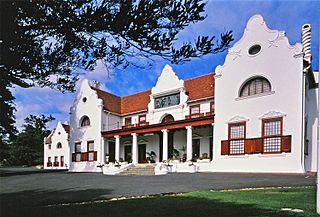
Groote Schuur is an estate in Cape Town, South Africa. In 1657, the estate was owned by the Dutch East India Company which used it partly as a granary. Later, the farm and farmhouse was sold into private hands. Groote Schuur was later acquired by William De Smidt, and remained in the family's possession until it was sold by Abraham De Smidt, Surveyor General of the Cape Colony, in 1878, and was bought by Hester Anna van der Byl of the prominent Van Der Byl / Coetsee family. In 1891 Cecil Rhodes leased it from her. He later bought it from her in 1893 for £60 000, and had it converted and refurbished by the architect Sir Herbert Baker. The Cape Dutch building, located in Rondebosch, on the slopes of Devil's Peak, the outlying shoulder of Table Mountain, was originally part of the Dutch East India Company's granary constructed in the seventeenth century.

<span class="mw-page-title-main">Liesbeek River</span> River in Cape Town, South Africa

The Liesbeek River is a river in Cape Town in South Africa. It is named after a small river in the Netherlands. The first "free burghers" of the Dutch East India Company were granted land to farm along the river in 1657, shortly after the first Dutch settlers arrived in the Cape. The river was originally called the Amstel or Versse Rivier. It is the first river that Jan van Riebeeck named.

<span class="mw-page-title-main">Newlands, Cape Town</span> Place in Western Cape, South Africa

Newlands (Nuweland) is an upmarket suburb of Cape Town, South Africa. It is located at the foot of Table Mountain in the Southern Suburbs of Cape Town, and is the wettest suburb in South Africa due to its high winter rainfall. The neighborhood of Bishopscourt is situated to its south west, Claremont to its south east, and Rondebosch to its east and north east.

<span class="mw-page-title-main">Southern Suburbs, Cape Town</span> Sub-region of Cape Town, South Africa

The Southern Suburbs are a group of Anglophone suburbs in Cape Town, Western Cape, South Africa. This group includes, among others, Observatory, Mowbray, Pinelands, Rosebank, Rondebosch, Rondebosch East, Newlands, Claremont, Lansdowne, Kenilworth, Bishopscourt, Constantia, Wynberg, Ottery, Plumstead, Diep River, Bergvliet and Tokai. The area is also commonly referred to as the Cape Peninsula, often including the towns further South such as Fish Hoek.

<span class="mw-page-title-main">Mowbray, Cape Town</span> Place in Western Cape, South Africa

Mowbray is one of the Southern Suburbs of Cape Town, South Africa and lies on the slopes of Devil's Peak. Mowbray is at a junction of several major Cape Town highways and has an important multi-modal public transport interchange at Mowbray railway station. Its original name was Driekoppen.

<span class="mw-page-title-main">Valkenberg Hospital</span> Hospital in Western Cape, South Africa

The Valkenberg Hospital is a large, government-funded, tertiary psychiatric hospital in the city of Cape Town, South Africa.

<span class="mw-page-title-main">Rosebank, Cape Town</span> Place in Western Cape, South Africa

Rosebank is one of the Southern Suburbs of Cape Town, South Africa, located between the suburbs of Mowbray and Rondebosch.

Hospital Bend is a major freeway junction, located to the east of the central business district of Cape Town, South Africa. It is the junction between the N2 national route and the M3 metropolitan expressway. Its unusual design led to notoriety as a traffic bottleneck and a frequent accident location; between March 2008 and early 2010 it underwent major roadworks to address these issues. It takes its name from it curving around the grounds of Groote Schuur Hospital.

<span class="mw-page-title-main">Observatory railway station</span> Metrorail station on the Southern Line

Observatory railway station is a Metrorail station serving the suburb of Observatory in Cape Town. It is served by trains on the Southern Line.

Raapenberg Bird Sanctuary is a 10-hectare (25-acre) protected area in Cape Town, located on the Liesbeek river near the suburb of Observatory.

The following is a timeline of the history of Cape Town in the Western Cape province of South Africa.

<span class="mw-page-title-main">Heart of Cape Town Museum</span> Specialized museums in Observatory, Cape Town South Africa

The Heart of Cape Town Museum is a museum complex in the Observatory suburb of Cape Town, South Africa. It is in the Groote Schuur Hospital on Main Road. The hospital was founded in 1938 and is famous for being the institution where the first human heart transplant took place, conducted by University of Cape Town-educated surgeon Christiaan Barnard on the patient Louis Washkansky. The museum opened on December 3, 2007, marking the 40th anniversary of the heart transplant by Christiaan Barnard. The Heart of Cape Town Museum honors everyone who played a major role in a surgical feat that created a new medical era. It also brings attention to ethical and moral implications that came up at the time. It also highlights the ways in which Barnard's accomplishment put South Africa and the University of Cape Town on an international stage.

Frances Rix Ames was a South African neurologist, psychiatrist, and human rights activist, best known for leading the medical ethics inquiry into the death of anti-apartheid activist Steve Biko, who died from medical neglect after being tortured in police custody. When the South African Medical and Dental Council (SAMDC) declined to discipline the chief district surgeon and his assistant who treated Biko, Ames and a group of five academics and physicians raised funds and fought an eight-year legal battle against the medical establishment. Ames risked her personal safety and academic career in her pursuit of justice, taking the dispute to the South African Supreme Court, where she eventually won the case in 1985.

<span class="mw-page-title-main">Groote Schuur Zoo</span> Zoo in Cape Town, South Africa

The Groote Schuur Zoo was a 2-hectare (4.9-acre) zoo in Cape Town, South Africa. Established in 1931 at the request of deceased Cecil Rhodes, it was free of charge and a very popular attraction in Cape Town until its closure sometime between 1975 and 1985. The zoo shut down due to a combination of the financial burden that the Apartheid government faced and an increase in animal welfare standards. During its operation, it housed many animals including lions, emu's, crocodiles and tahrs. The zoo can still be visited today, as it has been abandoned and left open to the public. The most prominent feature of the zoo is the Lion's Den, both when it was open and today where it still stands, full of overgrown vegetation.

Elmi Muller is a South African medical specialist who specialised in General Surgery and Transplantation. She currently performs kidney as well as liver transplants in both adults and children. She is the past President of the Southern African Transplantation Society who pioneered an organ transplant programme at Groote Schuur Hospital in Cape Town for HIV positive patients using HIV positive donors. She also serves on the Executive committee of The Transplantation Society of which she currently is the vice-president. Elmi was the Chair/Head of the Division of General Surgery at Groote Schuur Hospital, University of Cape Town. She currently serves as Dean: Faculty of Medicine and Health Sciences at Stellenbosch University.

<span class="mw-page-title-main">Coornhoop</span> Historic 17th century farmhouse in Cape Town

Coornhoop is a historic 17th century farmhouse. It is located at 2 Dixton Road in Observatory, Cape Town. Currently, it houses the Centre for Conflict Resolution.

<span class="mw-page-title-main">Outline of Cape Town</span> List of links to articles about Cape Town on Wikipedia

The following outline is provided as an overview of and topical guide to Cape Town:

<span class="mw-page-title-main">M4 (Cape Town)</span> Metropolitan route in the City of Cape Town, South Africa

The M4 is a long metropolitan route in the City of Cape Town Metropolitan Municipality in South Africa. It connects the Cape Town CBD with the Cape of Good Hope via Wynberg, Muizenberg and Fish Hoek. Originally, it was the main route connecting the Cape Town CBD with the Southern Suburbs and is thus named Main Road for much of its length. From the CBD to Kirstenhof, it is parallel to the M3 Freeway.

References

  1. 1 2 3 4 "Sub Place Observatory". Census 2011.
  2. "Observatory - Cape Town Tourism". Archived from the original on 30 April 2012. Retrieved 12 February 2012.
  3. 1 2 "History of the South African Astronomical Observatory". 2013. Retrieved 22 June 2014.
  4. "Invaders received a lesson in warfare". iol.co.za. Retrieved 8 March 2019.
  5. "Dovecot, Koornhoop, Dixon Road, Mowbray, Cape Town". 8 August 2012. Archived from the original on 14 January 2015. Retrieved 22 June 2014.
  6. "The History of Observatory". 31 May 2008. Archived from the original on 23 June 2008. Retrieved 17 August 2008.
  7. 1 2 "History of the South African Astronomical Observatory". South African Astronomical Observatory. 1995. Archived from the original on 16 January 2012. Retrieved 16 January 2012.
  8. "Heidelberg massacre: Story of reconciliation". 15 December 2009. Retrieved 22 June 2014.
  9. "AMNESTY GIVEN FOR HEIDELBERG TAVERN MASSACRE". 16 July 1998. Retrieved 22 June 2014.
  10. "bolo'bolo - anarchist publishing and events collective". Bolobolo.co.za. Retrieved 21 March 2022.
  11. "SIMON'S TOWN - WYNBERG - CAPE TOWN" (PDF). 2010. Archived from the original (PDF) on 25 February 2013. Retrieved 21 June 2014.
  12. "Wayback Machine has not archived that URL".[ dead link ]
  13. "Map of organisations". 22 August 2011. Retrieved 22 June 2014.
  14. "Coverage Map". Archived from the original on 14 January 2015. Retrieved 22 June 2014.
  15. "Official gazetting of heritage status" (PDF). Archived from the original (PDF) on 14 January 2015. Retrieved 22 June 2014.
  16. "Observatory Neighbourhood Watch Amended Constitution" (PDF). Retrieved 22 June 2014.
  17. Eligon, John (21 March 2022). "Plan for Amazon Headquarters in South Africa in Peril After Court Order". The New York Times.
  18. Prinsloo, Felix Njini and Loni. "High court suspends building of new Amazon headquarters in Cape Town | Fin24". Fin24. Retrieved 22 May 2022.
  19. "'History repeating': Amazon base in Cape Town splits Indigenous groups". the Guardian. 19 May 2022.