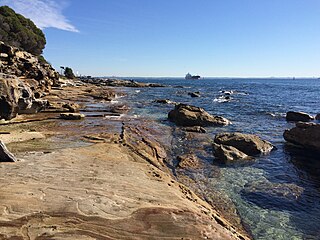
The Kamay Botany Bay National Park is a heritage-listed protected national park that is located in the eastern part of Botany Bay in Sydney, New South Wales, Australia. The 456-hectare (1,130-acre) national park is situated approximately 16 kilometres (9.9 mi) south-east of the Sydney central business district, on the northern and southern headlands of Botany Bay. The northern headland is at La Perouse and the southern headland is at Kurnell.

Cape Le Grand National Park is a national park in Western Australia, 631 km (392 mi) south-east of Perth and 56 km (35 mi) east of Esperance. The park covers an area of 31,801 hectares The area is an ancient landscape which has been above sea level for well over 200 million years and remained unglaciated. As a result, the area is home to many primitive relict species. Established in 1966, the park is managed by the Department of Parks and Wildlife. The name Le Grand is from one of the officers on L'Espérance, one of the ships in the 1792 expedition of Bruni d'Entrecasteaux.

Plettenberg Bay, nicknamed Plett, is the primary town of the Bitou Local Municipality in the Western Cape Province of South Africa. According to the census of 2001, the town had a population of 29,149. It was originally named Bahia Formosa by early Portuguese explorers and lies on South Africa's Garden Route 210 km from Port Elizabeth and about 600 km from Cape Town.

Paternoster is one of the oldest fishing villages on the West Coast of South Africa. It is situated 15 km north-west of Vredenburg and 145 km north of Cape Town, at Cape Columbine between Saldanha Bay and St Helena Bay. The town covers an area of 194.8 hectare and has approximately 1883 inhabitants.
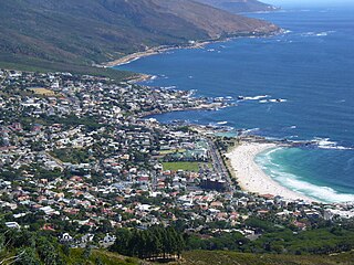
Camps Bay is an affluent suburb of Cape Town, South Africa, and the small bay on the west coast of the Cape Peninsula after which it is named. In summer it attracts many South African and foreign visitors.

The Cape Peninsula is a generally mountainous peninsula that juts out into the Atlantic Ocean at the south-western extremity of the African continent. At the southern end of the peninsula are Cape Point and the Cape of Good Hope. On the northern end is Table Mountain, overlooking Table Bay and the City Bowl of Cape Town, South Africa. The peninsula is 52 km long from Mouille point in the north to Cape Point in the south. The Peninsula has been an island on and off for the past 5 million years, as sea levels fell and rose with the ice age and interglacial global warming cycles of, particularly, the Pleistocene. The last time that the Peninsula was an island was about 1.5 million years ago. Soon afterwards it was joined to the mainland by the emergence from the sea of the sandy area now known as the Cape Flats. The towns and villages of the Cape Peninsula and Cape Flats, and the undeveloped land of the rest of the peninsula now form part of the City of Cape Town metropolitan municipality. The Cape Peninsula is bounded to the north by Table Bay, to the west by the open Atlantic Ocean, and to the east by False Bay in the south and the Cape Flats in the north.
Muizenberg is a beach-side town in the Western Cape, South Africa. It is situated where the shore of the Cape Peninsula curves round to the east on the False Bay coast. It is considered to be the main surfing spot in Cape Town and is currently home to a surfing community, centered on the popular 'Surfer's Corner'.

Noordhoek is a seaside town in the Western Cape, South Africa, located below Chapman's Peak on the west coast of the Cape Peninsula and is approximately 35 kilometres (22 mi) to the south of Cape Town. The name "Noordhoek" was taken from Dutch and literally means "north corner". It was given this name in 1743 as being the northern corner of the Slangkop farm. The first permanent resident of European origin is Jaco Malan who built his house there. In 1857, the region was divided into six plots, most of which were bought by a single family, that of the de Villiers. Noordhoek nevertheless remains a predominantly rural area where farmers grow vegetables to supply ships calling at Simon's Town. It is best known for its shoreline and its long, wide, sandy beach, which stretches south to the neighbouring village of Kommetjie. Near the southern end of this beach is the wreck of the steamship "Kakapo", which ran aground in 1900, when the captain mistook Chapman's Peak for the Cape of Good Hope and put the helm over to port.

Bloubergstrand is a seaside suburb of the City of Cape Town, South Africa, along the shores of Table Bay, 15 kilometres (9.3 mi) due north of the city centre of Cape Town. The name Bloubergstrand literally means "blue mountain beach" in Afrikaans, and is derived from Blaauwberg, a nearby hill. Bloubergstrand is mainly a residential area, and attracts large numbers of visitors especially kitesurf enthusiasts. The beach at Bloubergstrand is a popular location for a classic view of Table Mountain across the bay and is one of the world's top kitesurf destinations. Robben Island is located 6.9 kilometres (4.3 mi) west of the coast of Bloubergstrand.

Milnerton is a seaside town on Table Bay and is located north of Cape Town in South Africa. It is located 11 kilometres to the north of the city's centre.

Helderberg refers to a planning district of the City of Cape Town metropolitan municipality, the mountain after which it is named, a wine-producing area in the Western Cape province of South Africa, or a small census area in Somerset West.
Pallarenda is a northern coastal suburb of Townsville in the City of Townsville, Queensland, Australia. In the 2016 census Pallarenda had a population of 791 people.

Kleinmond is a small coastal town in the Overberg region of the Western Cape province, South Africa. It is situated inside a UNESCO-declared biosphere about 90 km east of Cape Town between Betty's Bay and Hermanus. The town's name, meaning "small mouth" in Afrikaans, refers to its location at the mouth of the Bot River lagoon. Stone axe heads found in the area indicate that people already lived in the vicinity of nearby Hangklip 20,000 years ago. Information about the area has existed in writing since the seventeenth century.
Wasque ("way-squee") or Wasque Beach is a 200-acre (0.81 km2) nature reserve on Chappaquiddick Island, Martha's Vineyard, Massachusetts. The site was established as a reservation for the public in 1967 and is one of five conservation areas on "the Vineyard" managed by the Trustees of Reservations. Wasque contains a sandy strand the Boston Globe calls "a magnificent beach." Travel + Leisure named Wasque Beach the number one beach in New England and WHDH-TV reports "It's pristine, serene, and rain or shine, it's a beach-goers' delight." Off the shore of Wasque Beach is Katama Bay, "a vast and pristine salt water bay that includes many acres of productive shellfish beds."

Waquoit Bay National Estuarine Research Reserve (WBNERR) encompasses open waters, barrier beaches, marshlands and uplands on the south shore of Cape Cod in the towns of Falmouth and Mashpee. The park is managed by the Department of Conservation and Recreation (DCR) and the National Oceanic and Atmospheric Administration.
Franskraalstrand, also known as Franskraal, is a coastal village near to Gansbaai in the Western Cape province of South Africa. As of 2011 it had a population of 1,165 people in 592 households.

Coffee Bay is a town on the Wild Coast of the Eastern Cape Province of South Africa. It is located about 250 kilometres south-west of the city of Durban and has a population of 258 people.
Morgan Bay is a village in Amathole District Municipality in the Eastern Cape province of South Africa.

Strandfontein is a seaside resort 8 km east of Muizenberg and just west of Michells Plain, on the northern shore of False Bay in the City of Cape Town municipality in the Western Cape province of South Africa.

The following outline is provided as an overview of and topical guide to Cape Town:


