Different methods of transportation in South Africa include roads, railways, airports, water, and pipelines for petroleum oil. The majority of people in South Africa use informal minibus taxis as their main mode of transport. BRT has been implemented in some South African cities in an attempt to provide more formalised and safer public transport services. These systems have been widely criticised due to their large capital and operating costs. A "freeway" is different from most countries as certain things are forbidden which include certain motorcycles, no hand signals, and motor tricycles. South Africa has many major ports including Cape Town, Durban, and Port Elizabeth that allow ships and other boats to pass through, some carrying passengers and some carrying petroleum tankers.
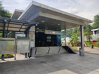
HarbourFront MRT station is an underground Mass Rapid Transit (MRT) interchange station in Singapore. The termini of the North East line (NEL) and Circle line (CCL), the station serves the HarbourFront area and Sentosa. Surrounding retail and commercial developments include VivoCity and HarbourFront Centre, and the station is near HarbourFront Bus Interchange and the Singapore Cruise Centre.
Muizenberg is a beach-side town in the Western Cape, South Africa. It is situated where the shore of the Cape Peninsula curves round to the east on the False Bay coast. It is considered to be the main surfing spot in Cape Town and is currently home to a surfing community, centered on the popular 'Surfer's Corner'.
Theodore Tugboat is a Canadian children's television series about a tugboat named Theodore who lives in the Big Harbour with all of his friends. The show originated in Halifax, Nova Scotia, Canada as a co-production between the CBC, and the now defunct Cochran Entertainment, and was filmed on a model set using radio controlled tugboats, ships, and machinery. Production of the show ended in 2001, and its distribution rights were later sold to Classic Media. The show premiered in Canada on CBC Television, then went to PBS, was on Qubo in the United States, and has appeared in eighty different countries.

Milnerton is a seaside suburb on Table Bay and is located north of central Cape Town in South Africa. It is located 11 kilometres to the north of the city's centre.

Art on the Underground, previously called Platform for Art, is Transport for London's (TfL) contemporary public art programme. It commissions permanent and temporary artworks for London Underground, as well as commissioning artists to create covers for the Tube map, one of the largest public art commissions in the UK.
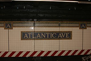
Many New York City Subway stations are decorated with colorful ceramic plaques and tile mosaics. Of these, many take the form of signs, identifying the station's location. Much of this ceramic work was in place when the subway system originally opened on October 27, 1904. Newer work continues to be installed each year, much of it cheerful and fanciful.
Milnerton High School is a public English medium co-educational high school for Grades 8 to 12, situated in the Milnerton suburb of Cape Town, Western Cape, South Africa.

Hall/Nimbus is a train station in Beaverton, Oregon, United States, served by TriMet as part of WES Commuter Rail. It is the second station southbound on the commuter rail line, which runs between Beaverton and Wilsonville in the Portland metropolitan area's Washington County. Opened in February 2009, the TriMet-owned station is located west of Oregon Route 217 near the Washington Square shopping mall on Hall Boulevard. It includes a 50-car park and ride and connections to TriMet bus routes 76–Hall/Greenburg and 78–Beaverton/Lake Oswego. WES connects with the Blue and Red lines of MAX Light Rail at Beaverton Transit Center.
The Cape Town Civic Centre is a building on the Foreshore in central Cape Town, South Africa that serves as the headquarters of the City of Cape Town, the municipality that governs Cape Town and its suburbs.

MyCiti is a bus rapid transit service with feeders, which forms part of a greater Integrated Public Transport driven economic development strategy of the City of Cape Town Municipality (CoCT) in South Africa. The service is being rolled out across the Cape Metropole, and provides a significantly enhanced public transport system in about 10% of the City. The service commenced in 2010 with Phase 1, which features buses running north to south along the west coastline of the City.
Joe Slovo Park is a township located between Milnerton and Montague Gardens near Cape Town, South Africa.

The South African Railways Class S2 0-8-0 of 1952 was a steam locomotive.
Dunoon is a city in the Western Cape province of South Africa. The first erf for Dunoon was surveyed in 1996. As formal housing was built, shacks developed rapidly.
Wescape is a proposed development project located in the north-west area of the City of Cape Town, South Africa. The Wescape development, proposed by urban development company communiTgrow, is 3,100 hectares and once completed will reportedly include 200,000 houses, 400 education facilities, 370 public service facilities and 15 sports complexes.

The Cenotaph is a war memorial on Heerengracht Street in Cape Town. The city's annual Remembrance Day ceremonies are held there. It is classified as a public memorial and as such is subject to protection in terms of heritage legislation administered by Heritage Western Cape, the provincial heritage resources authority of the Western Cape province of South Africa.
Julia Anastasopoulos is a South African artist, illustrator, designer and actress. Anastasopoulos became a local internet phenomenon in May 2014, with her do-it-yourself web series known as SuzelleDIY. Before she became a YouTube personality, Anastasopoulos created hand-drawn illustrations on the walls and windows of a few MyCiTi bus stations.
Kloof Nek Road, one of South Africa's oldest roads, was built in 1848 as an access road for the suburban pass with the same name which was used primarily as a look-out post for soldiers and a supply route to Camps Bay. The route starts at Kloof Street on the edge of the city bowl and turns into Camps Bay Road at the end of a mountain pass running between Table Mountain and Lion's Head. Despite being only two kilometers long, it is very steep with an average gradient 1:11. The summit of Kloof Nek Road is a small but complicated intersection that's not clearly visible on approach and often catches motorists unaware. The road's steepness may be a contributor to the regular occurrence of often-fatal accidents on Kloof Nek Road.
Brooklyn is a suburb of Cape Town, Western Cape with a population of 10,941 people. It lies to the north of Maitland, east of the Atlantic Ocean and Paarden Eiland, and west of Air Force Base Ysterplaat. The Black River flows through a section of Brooklyn.

The following outline is provided as an overview of and topical guide to Cape Town:
 Milnerton
 Paarden Eiland
 Vrystaat
 Woodbridge Island
 Zoarvlei
 Gardens Station - bench, following designs of Gaudi
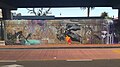 Gardens Station


