
The geography of North Carolina falls naturally into three divisions — the Appalachian Mountains in the west, the central Piedmont Plateau, and the eastern Atlantic Coastal Plain. North Carolina covers 53,821 square miles (139,396 km2) and is 503 miles (810 km) long by 150 miles (241 km) wide. The physical characteristics of the state vary from the summits of the Smoky Mountains, an altitude of near seven thousand feet (2,130 m) in the west, sloping eastward to sea level along the coast and beaches of the Atlantic Ocean.

The Mitchell River is a river located in Far North Queensland, Australia. The river rises on the Atherton Tableland about 50 kilometres (31 mi) northwest of Cairns and flows about 750 kilometres (470 mi) northwest across Cape York Peninsula from Mareeba to the Gulf of Carpentaria.

Kyaukse is town and capital of Kyaukse District in Mandalay Region, Myanmar. Lying on the Zawgyi River, 25 miles south of Mandalay, it is served by the Mandalay-Yangon (Rangoon) railway. The first Myanmar probably settled in the area about 800, and local 12th- and 13th-century inscriptions refer to Kyaukse as “the first home”. Remains of pagodas and old cities are found throughout the area. The Shwethalyaung Pagoda, built by King Anawrahta (1044–77), is located in Kyaukse.

Mandalay State Beach is a protected beach in the city of Oxnard, California, United States. Managed by the California Department of Parks and Recreation, the park preserves an area of undeveloped sand dunes and wetlands that was once common along the 16.5-mile-long (26.6 km) coastline of the Oxnard Plain.
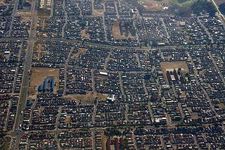
Mitchells Plain is a township in the Western Cape, South Africa about 28 km (17 mi) from the city of Cape Town. It is one of South Africa's largest residential areas. It is located on the Cape Flats on the False Bay coast between Muizenberg and Khayelitsha. Conceived of as a "model suburb" by the apartheid government, it was built during the 1970s to provide housing for Coloured victims of forced removal due to the implementation of the Group Areas Act.

Malmo Plains is a residential neighbourhood in south west Edmonton, Alberta, Canada. The University of Alberta family residences, called Michener Park, comprise the west end of the neighbourhood. The neighbourhood is named for a type of soil, malmo silty clay loam, common in the area.
Mandalay is the second largest city in Myanmar (Burma).
Crawford Plains is a residential neighbourhood located in the Mill Woods area of south Edmonton, Alberta, Canada. It is a part of the Mill Woods community of Southwood. It was named in 1976 to honour Neil Stanley Crawford, a provincial cabinet minister and former Edmonton alderman, "in recognition of his public service as a member of the Edmonton Historical Board, Local Board of Health and city council."

Philippi is a large urban and semi-urban area in the Western Cape, South Africa and is forms part of Cape Town's Cape Flats region. It comprises the Philippi Horticultural Area to the west, and some of Cape Town's larger townships located within its eastern half just south of Gugulethu & Nyanga. The horticultural area is sparsely populated compared to the surrounding city and contains many farms. Urban areas within Philippi include Browns Farm, Samora Machel/Weltevreden Valley North, Heinz Park, Phola Park, and Philippi East.

Mutual railway station is a Metrorail commuter rail station located between the suburbs of Maitland and Pinelands in Cape Town, South Africa. It is situated next to the South African headquarters of the Old Mutual, from which it takes its name. Mutual is a particularly busy station because it is the junction at which the Central Line towards Mitchell's Plain and Khayelitsha diverges from the Northern Line main line to Bellville.
The Central Line is a commuter rail service in Cape Town, South Africa, operated by Metrorail Western Cape. Central Line services operate along two routes from central Cape Town to Langa, and then along three branches from Langa to various areas in the south-east of the city. The first branch runs to Mitchell's Plain, the second to Khayelitsha, and the third passes through Belhar to terminate in Bellville.

Wolfgat Nature Reserve is a coastal nature reserve in Mitchells Plain on False Bay in the Western Cape, South Africa.

Ibhayi is a large township near Port Elizabeth, South Africa. It is the largest township in the Eastern Cape province and the ninth largest in South Africa after Mitchells Plain near Cape Town in the Western Cape.

The Alice River is a river located on the Cape York Peninsula of Far North Queensland, Australia.

Eastridge is a neighborhood located within the Mitchells Plain urban area of the City of Cape Town in the Western Cape province of South Africa.
Rocklands is a neighborhood located within the Mitchells Plain urban area of the City of Cape Town in the Western Cape province of South Africa. It is located in the south western most corner of Mitchells Plain and boarders the community of Strandfontein to its intimidate west.
Portland is a neighborhood located within the Mitchells Plain urban area of the City of Cape Town in the Western Cape province of South Africa. It is located within the central area of Mitchells Plain with Mitchells Plain Town Centre located to its immediate east.

Westgate is a neighbourhood located within the Mitchells Plain urban area of the City of Cape Town in the Western Cape province of South Africa. It is located in the central western part of Mitchells Plain. Westgate Mall is located to the neighbourhood's immediate north on the other side of Morgenster Road.
Tafelsig is a neighbourhood located within the Mitchells Plain urban area of the City of Cape Town in the Western Cape province of South Africa. It is located in the south eastern corner of the Mitchells Plain area.
Lentegeur is a neighbourhood located within the Mitchells Plain urban area of the City of Cape Town in the Western Cape province of South Africa. It is located in the north eastern section of the Mitchells Plain area. The 400 bed Mitchells Plain Hospital, one of Cape Town's larger hospitals, is located in the nieghbourhood. The Lentegeur Sports Grounds dominate central area of the neighbourhood.

