Milnerton

Last updated
Milnerton
Cape Town 30 Jan 2012 005.JPG
View of Table Mountain from Milnerton beach
South Africa Western Cape location map.svg
Red pog.svg
Milnerton
South Africa adm location map.svg
Red pog.svg
Milnerton
Africa location map.svg
Red pog.svg
Milnerton
Coordinates: 33°52′S18°30′E / 33.867°S 18.500°E / -33.867; 18.500
Country South Africa
Province Western Cape
Municipality City of Cape Town
Area
[1]
  Total43.70 km2 (16.87 sq mi)
Population
 (2011) [1]
  Total95,630
  Density2,200/km2 (5,700/sq mi)
Racial makeup (2011)
[1]
   Black African 29.9%
   Coloured 17.3%
   Indian/Asian 2.6%
   White 47.7%
  Other2.4%
First languages (2011)
[1]
   English 55.5%
   Afrikaans 18.0%
   Xhosa 14.0%
  Other12.4%
Time zone UTC+2 (SAST)
Postal code (street)
7441
PO box
7435
Area code 021
View from Milnerton beach towards Cape Town, showing Table Mountain, Lion's Head and Signal Hill. Cape Town sunset Milnerton Beach.jpg
View from Milnerton beach towards Cape Town, showing Table Mountain, Lion's Head and Signal Hill.

Milnerton is a seaside town on Table Bay and is located north of Cape Town in South Africa. It is located 11 kilometres to the north of the city's centre.

Contents

Geography

Milnerton lies on the Western Seaboard of Cape Town, also known as the Blaauwberg Coast, just north of the city along Table Bay. Although Milnerton is a town in its own right, it still regarded as a suburb of Cape Town. It borders on the suburbs of Blouberg and Table View to the north, Parow to the east and Goodwood to the south. [2] [3]

Much of the town is situated east of the Diep River lagoon (Milnerton Lagoon) with the exception of the coastal suburbs of Woodbridge Island, Sunset Links and Sunset Beach situated west of the lagoon. Milnerton Central, only about 0,1 km2 in size is situated between Marine Drive and Koeberg Road and is situated east of Woodbridge Island. [4]

Suburban areas

Suburbs of the greater Milnerton area include: [5]

Milnerton lagoon

One of the most identifiable features of Milnerton is its lagoon, formed where the Diep River enters the sea, with palm trees adorning the lagoon banks.

The lagoon is also known as Schitt's Creek, due to the pungent smell that is emitted into the adjacent environment.

Woodbridge Island

Woodbridge Island is not actually an island, but rather the area south of Milnerton Golf Club on the peninsula separating the lagoon from the ocean. Two bridges join Woodbridge Island to the mainland of Milnerton proper. The wooden bridge is now a national heritage site, the bridge went through an upgrade phase and has since been reopened to the public. A newer bridge allows cars to cross to the island. The Milnerton Lighthouse is also a popular landmark found on the island. The beach is a popular recreational area, especially over weekends and public holidays.

Milnerton beach

Milnerton's beach is well known for its view of Table Mountain and is a popular surfing spot. The water is generally cold as a result of the Benguela current that flows along Africa's western shore. The beach is also managed by Milnerton Surf Lifesaving Club, who help to prevent drownings on the beach and surrounding area. Every Wednesday during summer the surfski and stand up paddlers use the SE winds and race the Downwind Dash series to Big Bay beach.

Nature reserves

Milnerton is the location of two nature reserves which are owned and managed by the City of Cape Town. The Table Bay Nature Reserve Milnerton Racecourse Section is situated inside the race tracks of the old Milnerton Racecourse.

Transport

The N7 (Cape Namibia Route) is the main highway bisecting Milnerton, running north–south from Malmesbury to Goodwood and passing the interchanges at Bosmansdam and Plattekloof Roads. The N1 highway borders Milnerton to the south, passing Century City and Paarden Eiland and runs east–west from Paarl to Cape Town. The R27 (Marine Drive; Otto du Plessis Drive) roughly runs north–south along the coast from Melkbosstrand and Table View towards Cape Town.

Milnerton is also served by five metropolitan routes linking it to surrounding towns and cities in the City of Cape Town. The M5 (Koeberg Road) runs N to S from Killarney Gardens to and Muizenberg. The M8 (Bosmansdam Road) runs W to E from Milnerton to Plattekloof. The M12 (Giel Basson Drive) runs N to S from Burgundy Estate and Sunningdale to Parow and Goodwood. The M13 (Tygerberg Valley Drive) roughly runs W to E from Milnerton to Richwood and Durbanville. The M14 (Plattekloof Road) runs W to E from Milnerton to Plattekloof.

Coat of arms

Milnerton had its own municipality from 1955 to 1996. The town council assumed a coat of arms, designed by Cornelis Pama, in October 1963, [6] and registered it with the Cape Provincial Administration in February 1966 [7] and at the Bureau of Heraldry in February 1968. [8]

The arms were : Per chevron ploye Or with two horse-shoe Gules, and barry wavy of eight Azure and Argent (i.e. the shield was divided by a curved chevron-shaped line, the upper part displaying two red horseshoes on a gold background and the lower part having eight silver and blue stripes with wavy edges).

The crest was a red demi-horse and the motto Per mare per terram.

Related Research Articles

<span class="mw-page-title-main">Bellville, South Africa</span> Town in Western Cape, South Africa.

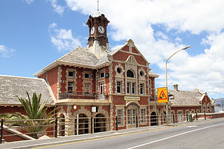
Bellville is a town and former independent city that is now incorporated into the City of Cape Town Metropolitan Municipality in the Western Cape province of South Africa. The town is an industrial and commercial node, a university town, and a major transportation hub within the Greater Cape Town metropolis.

<span class="mw-page-title-main">Muizenberg</span> Coastal town in the Western Cape, South Africa

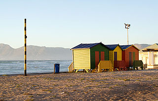
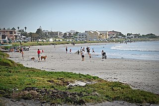
Muizenberg is a beach-side town in the Western Cape, South Africa. It is situated where the shore of the Cape Peninsula curves round to the east on the False Bay coast. It is considered to be the main surfing spot in Cape Town and is currently home to a surfing community, centered on the popular 'Surfer's Corner'.

<span class="mw-page-title-main">Beaches of Cape Town</span> List of beaches in the Cape Town metropolitan region

The Cape Metropole has a wide variety of beaches divided into three regions by the Cape Peninsula:

<span class="mw-page-title-main">City of Cape Town</span> Metropolitan municipality in Western Cape, South Africa

The City of Cape Town is the local government of Cape Town and surrounding areas. As of the 2016 community survey, it had a population of 4,005,016.

<span class="mw-page-title-main">M5 (Cape Town)</span> Metropolitan route in the City of Cape Town, South Africa

The M5 is an expressway in the City of Cape Town Metropolitan Municipality, South Africa. It connects Milnerton on the Western Seaboard in the north to Muizenberg in the south, and crosses both the N1 and the N2. For part of its length, from the N1 interchange to Plumstead, it is a limited-access freeway (motorway). From Mowbray to Muizenberg, it is parallel to the M4 Main Road.

<span class="mw-page-title-main">Melkbosstrand</span> Seaside suburb of Cape Town, in Western Cape, South Africa

Melkbosstrand is a coastal town located on the South West Coast of South Africa, 30 km north of Cape Town. It forms part of the City of Cape Town Metropolitan Municipality, the municipality governing Cape Town and its greater metropolitan area.

<span class="mw-page-title-main">Durbanville</span> Town in Western Cape, South Africa

Durbanville is a town in the Western Cape province of South Africa, part of the greater Cape Town metropolitan area. Durbanville is a semi-rural residential suburb on the north-eastern outskirts of the metropolis surrounded by farms producing wine and wheat.

<span class="mw-page-title-main">Liesbeek River</span> River in Cape Town, South Africa

The Liesbeek River is a river in Cape Town in South Africa. It is named after a small river in the Netherlands. The first "free burghers" of the Dutch East India Company were granted land to farm along the river in 1657, shortly after the first Dutch settlers arrived in the Cape. The river was originally called the Amstel or Versse Rivier. It is the first river that Jan van Riebeeck named.

<span class="mw-page-title-main">Parow, South Africa</span> Place in Western Cape, South Africa

Parow is a suburb of Cape Town in the Western Cape, South Africa and a Northern Suburb of the City of Cape Town Metropolitan Municipality founded by Johann Heinrich Ferdinand Parow who arrived in the locality in 1865.

<span class="mw-page-title-main">MyCiTi</span>

MyCiti is a bus rapid transit service with feeders, which forms part of a greater Integrated Public Transport driven economic development strategy of the City of Cape Town Municipality (CoCT) in South Africa. The service is being rolled out across the Cape Metropole, and provides a significantly enhanced public transport system in about 10% of the City. The service commenced in 2010 with Phase 1, which features buses running north to south along the west coastline of the City.

Dozens of fortifications were built in Cape Town and the Cape Peninsula between the 1650s and the 1940s. Most have gone, but a few still stand.

The Diep River Fynbos Corridor is a nature reserve located in the Blaauwberg region of Cape Town, South Africa. It forms part of the larger Table Bay Nature Reserve, which was established in June 2012.

Parklands College and Christopher Robin Pre-Primary are private schools situated in Parklands, near Cape Town, South Africa. The college is managed by a board of directors represented by the managing director.

MyCiTi bus stations host the MyCiTi bus lines that travel throughout the greater Cape Town area.

Brooklyn is a suburb of Cape Town, Western Cape with a population of 10,941 people. It lies to the north of Maitland, east of the Atlantic Ocean and Paarden Eiland, and west of Air Force Base Ysterplaat. The Black River flows through a section of Brooklyn.

<span class="mw-page-title-main">Outline of Cape Town</span> List of links to articles about Cape Town on Wikipedia

The following outline is provided as an overview of and topical guide to Cape Town:

Ysterplaat is a northern suburb of Cape Town, South Africa, around 10 km west-northwest of City Hall. It borders Paarden Eiland to the southwest, Brooklyn and Rugby to the west, Kensington to the south, and Century City to the northeast.

Killarney Gardens is an industrial area of Cape Town with no population or households. It is located about 30 minutes away from the harbour and the airport and situated between the N1, the N7 and Plattekloof roads.

The M12 is a long metropolitan route in the City of Cape Town, South Africa. It connects Burgundy Estate with Stellenbosch via Parow, Elsie's River and Kuils River.

References

  1. 1 2 3 4 "Main Place Milnerton". Census 2011.
  2. "Census 2011: Metropolitan Municipality: City of Cape Town". census2011.adrianfrith.com. Retrieved 2023-07-18.
  3. "BLAAUWBERG, Cape Town". www.sa-venues.com. Retrieved 2023-09-14.
  4. "Census 2011: Small Area: Small Area 3086". census2011.adrianfrith.com. Retrieved 2023-07-18.
  5. "Census 2011: Main Place: Milnerton". census2011.adrianfrith.com. Retrieved 2020-08-21.
  6. Western Cape Archives : Milnerton Municipal Minutes (16 October 1963).
  7. Cape of Good Hope Official Gazette 3332 (18 February 1966).
  8. http://www.national.archsrch.gov.za%5B%5D