Parow, South Africa

Last updated

{{Infobox settlement | name = Parow | image_skyline = 2011-06-20 13-08-13 South Africa - Parow.JPG | image_caption = Aerial view of Parow | pushpin_map = South Africa Western Cape#South Africa#Africa | coordinates = 33°54′00″S18°36′00″E / 33.90000°S 18.60000°E / -33.90000; 18.60000 | subdivision_type = [[Country]https://en.wikipedia.org/w/index.php?title=Parow,_South_Africa&action=edit] | subdivision_name = South Africa | subdivision_type1 = Province | subdivision_name1 = Western Cape | subdivision_type2 = District | subdivision_type3 = Municipality | subdivision_name3 = City of Cape Town | subdivision_type4 = Main Place | subdivision_name4 = | established_title = Established | leader_title = Councillor | area_footnotes = [1] | area_total_km2 = 27.08 | population_footnotes = [1] | population_total = 119462 | population_as_of = 2011 | population_density_km2 = auto | demographics_type1 = Racial makeup (2011) | demographics1_footnotes = [1] | demographics1_title1 = Black African | demographics1_info1 = 9.6% | demographics1_title2 = Coloured | demographics1_info2 = 58.4% | demographics1_title3 = Indian/Asian | demographics1_info3 = 4.3% | demographics1_title4 = White | demographics1_info4 = 25.5% | demographics1_title5 = Other | demographics1_info5 = 2.2% | demographics_type2 = First languages (2011) | demographics2_footnotes = [1] | demographics2_title1 = Afrikaans | demographics2_info1 = 65.6% | demographics2_title2 = English | demographics2_info2 = 26.8% | demographics2_title3 = Xhosa | demographics2_info3 = 2.3% | demographics2_title4 = | demographics2_info4 = | demographics2_title5 = Other | demographics2_info5 = 5.3% | timezone1 = SAST | utc_offset1 = +2 | postal_code_type = Postal code (street) | postal_code = 7500 | postal2_code_type = PO box | postal2_code = 7499 | area_code_type = Area code | area_code = 021 }} Parow is a town of Cape Town in the Western Cape, South Africa and a Northern Suburb of the City of Cape Town Metropolitan Municipality founded by Johann Heinrich Ferdinand Parow who arrived in the locality in 1865.

Contents

History

During a great storm in Table Bay in 1865, 19 ships were stranded. Amongst the many schooners was the Kehrwieder, the ship of Captain Johann Heinrich Ferdinand Parow. After being stranded, Captain Parow settled down in the Cape of Good Hope and married Johanna Wilhelmina Timmerman, the daughter of the family that helped Captain Parow after being stranded on the Cape coast.

Parow quickly realised the potential value of the Tyger Valley area north of Cape Town and that the area held great opportunities for cattle trade. Captain Parow soon moved inland to this area and started selling ground in the area which is today known as Parow, which built up a great deal of wealth for the captain.

Parow died on 4 December 1910, in his house in Cassibelle, Maitland. His wife, JW Timmerman, died ten years prior. They did not have any children.

Captain Parow's telescope is in the Town Hall of Parow.

Modern day

A village management board was established for Parow in 1902. It was upgraded to a municipality in 1939. The municipality was incorporated into the City of Tygerberg in 1996.

The Parow valley was included in the Cape Town municipal land area in 1944. During the 1960s, 1970s and 1980s, Parow was largely transforming into a commercial area, with many shopping centres opening around Voortrekker road, one of the longest roads in Cape Town.

With the extreme political struggle of apartheid in the 1980s and the advent of democracy in the 1990s, Parow's popularity started to decline and many of its higher income population moved further north.

In 2005 Parow became the headquarters for the South African division of the International Alliance of Guardian Angels, the world's oldest and largest volunteer public safety patrol organisation.

Sports and other events are sometimes held in Parow Civic Centre.

Professional soccer clubs Ajax Cape Town and Vasco da Gama are based in Parow.

JSE listed retail group The Foschini Group are headquartered in Parow, adjadent to the dilapidated Parow Centre (formerly the Sanlam Centre).

Area

Parow consists of the following areas: Ravensmead, Florida, Beaconvale, Cravenby, Parow Valley, Klipkop, Parow, Parow East, Oostersee, Fairfield Estate, Glenlily, Churchill Estate, Clamhall, Avondale, De Tijger, Parow North, Panorama, Plattekloof, Welgelegen, Parow Industria

Economy

The Foschini Group, Pepkor, Coca-Cola Peninsula Beverages and De Haan's Bus & Coach are all based within the Parow district.

Education

The Parow Satellite Campus (Zweigstelle Parow) of the German International School Cape Town is in Parow. [2] It serves German-speaking students up to grade 4 and is in proximity to Tygerberg. [3]

Primary schools

Secondary schools

Tertiary institutions

Coat of arms

Parow was a municipality from 1939 to 1996. The town council assumed a coat of arms, designed by W.H. Armstrong & Co, on 30 November 1939. [4] It had them improved by Ivan Mitford-Barberton in 1955, registered them with the Cape Provincial Administration in July 1955, [5] had them granted by the provincial administrator in June 1967, [6] and registered them at the Bureau of Heraldry in September 1969. [7]

The original arms were: Gules, on a pale Or, three fleurs de lis Azure (i.e. a red shield displaying three blue fleurs de lis on a vertical gold stripe down the middle). The crest was a fleur de lis between a pair of wings; the supporters were a gemsbok and a lion; and the motto was Caute sed strenue. In the revised version, used from 1955, the shield was gold, the vertical stripe blue and the fleurs de lis silver.

Related Research Articles

= Biblical: Carmi, nephew of Jacob. | nickname = | motto = Where northern vigor meets southern hospitality | anthem = | image_map = File:White County Illinois Incorporated and Unincorporated areas Carmi Highlighted.svg | mapsize = | map_alt = | map_caption = Location of Carmi in White County, Illinois. | image_map1 = Illinois in United States (US48).svg | mapsize1 = | map_alt1 = | map_caption1 = Location of Illinois in the United States | pushpin_map = | pushpin_label_position = | pushpin_label = | pushpin_map_alt = | pushpin_mapsize = | pushpin_relief = | pushpin_map_caption = | coordinates = 38°5′18″N88°10′5″W | coor_pinpoint = | coordinates_footnotes = | grid_name = | grid_position = | subdivision_type = Country | subdivision_name = United States | subdivision_type1 = State | subdivision_name1 = Illinois | subdivision_type2 = County | subdivision_name2 = White | subdivision_type3 = Township | subdivision_name3 = | subdivision_type4 = | subdivision_name4 = | established_title = Founded | established_date = 1816 | founder = | named_for = | seat_type = | seat = | government_footnotes = | government_type = Mayor-council government | governing_body = | leader_party = | leader_title = Mayor | leader_name = Jeff Pollard | leader_title1 = Mayor | leader_name1 = | total_type = | unit_pref = Imperial | area_footnotes = | area_total_km2 = 6.79 | area_total_sq_mi = 2.62 | area_land_km2 = 6.71 | area_land_sq_mi = 2.59 | area_water_km2 = 0.08 | area_water_sq_mi = 0.03 | elevation_footnotes = | elevation_ft = 390 | elevation_point = | population_as_of = 2020 | population_footnotes = | population_total = 4865 | population_density_km2 = 725.41 | population_density_sq_mi = 1879.10 | timezone1 = CST | utc_offset1 = -6 | timezone1_DST = CDT | utc_offset1_DST = -5 | postal_code_type = ZIP Code(s) | postal_code = 62821 | area_code = 618 | blank_name = FIPS code | blank_info = 17-11293 | blank1_name = GNIS ID | blank1_info = 2393751 | blank2_name_sec2 = Wikimedia Commons | blank2_info_sec2 = Carmi, Illinois | website = www.cityofcarmi.com | footnotes = }}

<span class="mw-page-title-main">Stellenbosch</span> Town in Western Cape, South Africa

Stellenbosch is a town in the Western Cape province of South Africa, situated about 50 kilometres east of Cape Town, along the banks of the Eerste River at the foot of the Stellenbosch Mountain. The town became known as the City of Oaks or Eikestad in Afrikaans and Dutch due to the large number of oak trees that were planted by its founder, Simon van der Stel, to grace the streets and homesteads.

<span class="mw-page-title-main">Bellville, South Africa</span> Town in Western Cape, South Africa.

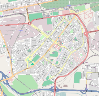
Bellville is a town and former independent city that is now incorporated into the City of Cape Town Metropolitan Municipality in the Western Cape province of South Africa. The town is an industrial and commercial node, a university town, and a major transportation hub within the Greater Cape Town metropolitan area.

<span class="mw-page-title-main">Swellendam</span> Town in Western Cape, South Africa

Swellendam is the third oldest town in South Africa, a town with 17,537 inhabitants situated in the Western Cape province. The town has over 50 provincial heritage sites, most of them buildings of Cape Dutch architecture. Swellendam is situated on the N2, approximately 220 km from both Cape Town and George.

<span class="mw-page-title-main">Pinelands, Cape Town</span> Place in Western Cape, South Africa

Pinelands is an affluent garden city suburb located on the edge of the southern suburbs of Cape Town, South Africa, neighbouring the suburb of Thornton, and is known for its large thatched houses and green spaces. The suburb is primarily residential and is often praised for its peacefulness and abundance of trees. Pinelands is one of the few areas in Cape Town in which sale of alcohol to the public is prohibited, but some clubs have private liquor licenses. It is a popular place for senior citizens to retire to. While there are several retirement homes in the suburb, younger people are increasingly moving in.

<span class="mw-page-title-main">Wynberg, Cape Town</span> Place in Western Cape, South Africa

Wynberg is a southern suburb of the City of Cape Town in Western Cape, South Africa. It is situated between Plumstead and Kenilworth, and is a main transport hub for the Southern Suburbs of Cape Town.

<span class="mw-page-title-main">City of Cape Town</span> Metropolitan municipality in South Africa

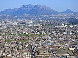
The City of Cape Town is a metropolitan municipality that forms the local government of Cape Town and surrounding areas. As of the 2016 community survey, it had a population of 4,005,016.

<span class="mw-page-title-main">Tygerberg</span> Region of the City of Cape Town, South Africa

Tygerberg is a district in the northern suburbs of Cape Town in South Africa. It is also the name of the range of hills in the area. The main Tygerberg farms were Pampoenkraal, Stellenburgh, Evertsdal, De Grendel, Lebenstijn, Blommensteijn, Door de Kraal, Vissershok and Clara Anna Fontein. It also contains the Tygerberg Nature Reserve.

<span class="mw-page-title-main">Durbanville</span> Town in Western Cape, South Africa

Durbanville, previously called Pampoenkraal, is a town in the Western Cape province of South Africa, part of the greater Cape Town metropolitan area. It is a semi-rural residential suburb on the north-eastern outskirts of the metropolis surrounded by farms producing wine and wheat.

<span class="mw-page-title-main">Milnerton</span> Seaside town in the Western Cape, South Africa

Milnerton is a seaside town on Table Bay and is located north of Cape Town in South Africa. It is located 11 kilometres to the north of the city's centre.

<span class="mw-page-title-main">Table View</span> Suburb of Cape Town, in Western Cape, South Africa

Table View is a West Coast suburb of Cape Town, South Africa, named after its view of Table Mountain. It has expanded rapidly since the 1970s and has extensions such as Flamingo Vlei, Sunridge, West Riding, Parklands, and Killarney. Table View has various shopping malls, such as Bayside Mall and Table Bay Mall.

<span class="mw-page-title-main">Helderberg</span> Region of the City of Cape Town, South Africa

Helderberg refers to a planning district of the City of Cape Town metropolitan municipality, the mountain after which it is named, a wine-producing area in the Western Cape province of South Africa, or a small census area in Somerset West.

<span class="mw-page-title-main">Wellington, South Africa</span> Place in Western Cape, South Africa

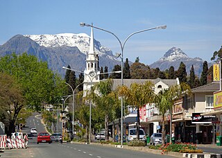
Wellington is a town in the Western Cape Winelands, a 45-minute drive from Cape Town, in South Africa with a population of approximately 62,000. Wellington's economy is centered on agriculture such as wine, table grapes, deciduous fruit, and a brandy industry. The town is located 75 km north-east of Cape Town, reached by the N1 motorway and R44. Due to the growth of the Vlakkeland and Mbekweni township south of the town, it now forms a de facto urban unit with Paarl, just 10 km to the south. Wellington now officially falls under the Drakenstein Local Municipality, which also covers Saron and Paarl.

<span class="mw-page-title-main">Elsie's River</span> Place in Western Cape, South Africa

Elsie's River is a suburb of Cape Town, South Africa.


Tajik: Пӯлодон

Goodwood is a suburb of Cape Town in the Western Cape, South Africa and is situated in the Tygerberg region of the City of Cape Town. It is 10 kilometres from Cape Town and accessible from the N1, N7 and N2 highways.

The German International School Cape Town is a German international school in Cape Town, South Africa. The school has English and German streams, available for primary school, middle school, and high school. The German stream is available for grades 1–12 while the English stream is available for grades 5–12.

<span class="mw-page-title-main">Northlink College</span> College in South Africa

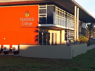
Northlink College is a Government higher education institution situated in Bellville, Western Cape, South Africa. It is fully accredited by the Council on Higher Education and Department of Higher Education and Training (DoHET)(South Africa). The College is quality assured by the South African Council on Higher Education (CHE).

<span class="mw-page-title-main">Durbanville High School</span> High school in Durbanville, South Africa

Hoërskool Durbanville is a public Afrikaans medium co-educational high school situated in the town of Durbanville in the Western Cape province of South Africa. It is a public school. It is the oldest High School in the Northern Suburbs of Cape Town, and the only other school older in the Greater Cape Town metropolitan area is Simons Town School in the southern suburbs.

<span class="mw-page-title-main">Northern Suburbs, Cape Town</span> Sub-region of the City of Cape Town, South Africa

The Northern Suburbs is a major urban and rural region located in the City of Cape Town Metropolitan Municipality in the Western Cape province of South Africa. It is the urban north-eastern part of the Greater Cape Town metropolitan area that is functionally merged with Cape Town.

References

  1. 1 2 3 4 "Main Place Parow". Census 2011.
  2. "Location of School" ( Archived 2015-07-11 at the Wayback Machine ). German International School Cape Town. Retrieved on August 8, 2015. Address: "Parow North Recreation Centre De Grendel Road, Parow" Directions in German (Archive), Parow Map (Archive).
  3. "Satellite Campus in Tygerberg/Parow" ( Archived 2015-09-23 at the Wayback Machine ). German International School Cape Town. Retrieved on August 8, 2015. Page in German The University of South Africa is also situated as a regional campus in Parow, and serves as a satellite campus for university, sitting in Pretoria. (Archive).
  4. Western Cape Archives : Parow Municipal Minutes (30 November 1939).
  5. Cape of Good Hope Official Gazette 2764 (1 July 1955).
  6. Cape of Good Hope Official Gazette 3408 (16 June 1967).
  7. http://www.national.archsrch.gov.za%5B%5D