Vredehoek | |
---|---|
Coordinates: 33°56′15″S18°25′30″E / 33.93750°S 18.42500°E | |
Country | South Africa |
Province | Western Cape |
Municipality | City of Cape Town |
Main Place | Cape Town |
Area | |
• Total | 0.94 km2 (0.36 sq mi) |
Population (2011) [1] | |
• Total | 3,556 |
• Density | 3,800/km2 (9,800/sq mi) |
Racial makeup (2011) | |
• Black African | 8.8% |
• Coloured | 5.6% |
• Indian/Asian | 2.0% |
• White | 80.4% |
• Other | 3.2% |
First languages (2011) | |
• English | 71.1% |
• Afrikaans | 18.3% |
• Other | 10.6% |
Time zone | UTC+2 (SAST) |
Postal code (street) | 8001 |
Vredehoek (Afrikaans: "peace corner" [2] ) is a residential suburb of Cape Town, South Africa, located at the foot of Table Mountain and Devil's Peak. It is sandwiched between the two neighbouring suburbs of Oranjezicht and Devil's Peak Estate, the latter of which is often considered a sub-suburb of Vredehoek as they both fall under the neighbourhood watch community called DPV - Devil's Peak & Vredehoek.
The suburb is easily recognised by the three cylindrical Disa Park towers, [3] many Art Deco-style buildings, and the natural beauty of public green spaces and parks. In 2011, the City of Cape Town census counted 5,415 people living in the area. [4]
It is served by route 111 and 101 of the MyCiTi bus service. [5]
The suburb was proclaimed after the first world war, where immigrants from many European countries settled after peace was declared, hence the name of "peace corner". Vredehoek Farm and Elba Farm were among the earliest settlements in the eighteenth and nineteenth centuries. [6] The Jurgens family were the original owners of Vredehoek farm in this period and where they built Vredehoek homstead, c1800. They sold the farm to Edward H. F. Mellish in 1883, “a man of means, energy, ability and high standards” and he transformed the farm into Cape Town's first dairy farm. [6] Coupled with Mellish' death in 1905 and the mismanagement of the property by his son, all farming on the property ceased in 1916. [6] Over the following decades, portions of the original farm were subdivided into residential lots. [6] The homestead and part of the farm was sold to the University of Cape Town in 1924 and the homestead was used as a hostel by South African College Schools. [6] Cape Town municipality purchased the property from the university in 1930. [6] They demolished the homestead and created public recreational fields on the land. [6] Some remaining part of the original estate were transferred to the Poor Sisters of Nazareth in 1926 and 1929. Elba Farm (later Prospect Hill Farm) was developed as Devil's Peak Estate, a residential suburb for Europeans. [6]
On 1 April 1888, Cape Town's mayor commemorated the opening of wash houses near the Platteklip (Dutch: "flat stone") Stream. [7] An estimated 200 washerwomen were expected to stop washing laundry in the stream and instead use new indoor facilities. This change was made as downstream small-holdings owners wanted clean water for crops and new sanitation laws were outlawing washing laundry in public streams. [7]
The new wash houses required the washerwomen to pay a fee and this led to an initial boycott, after which the fee was dropped. [7] Once the women began using the facility's standing basins, perhaps because of the comfort over bending to wash, the fee was re-introduced. [7]
Before slavery was abolished at the South Africa in 1834, [8] the washerwomen would have been primarily enslaved women. They used corn husks to scour lathered cloth and used nearby bushes, trees and rocks for places to hang wet laundry for drying. [7]
The Platteklip Stream's fresh water comes off Table Mountain. It has historically been used by indigenous pastoralists to water their animals and for wild animals like buck to drink. [7] The Khoekhoen people called the stream Camissa "The Place of Sweet Water" and European settlers who used it for refreshment after being at sea called it Varsche Rivier. [9]
Buitenkant Street was previously known as Slaves' Walk, used by enslaved people to take laundry to the washerwomen. [7]
Today, the site of the wash houses forms part of a roughly 3 km Washerwomen Trail and has been turned into an overnight cottage through SANParks. [7]
The public-access quarry above Vredehoek is a remnant of past tin mining in the area. [10] Officially called the "Murray and Stewart Quarry" and more commonly, the Vredehoek Quarry, [10] it is a popular place for people to visit with dogs or to see the fish that inhabit the quarry waters.[ citation needed ]
Mining started in 1911 [10] and in 1912 The Cape Argus reported that cassiterite was being fetched out of a 180-foot deep shaft via an adit. [11]
Mining was being carried out by an estimated 100 men employed by the Vredehoek Tin Company. [11] Mining was discontinued after it was realised that it would be cheaper to mine tin in the Durbanville area and operations stopped completely during World War 1. [10] It was reported that the mine had successfully produced roughly four tons (roughly 3600 kilograms) of ore concentrates. [10]
During apartheid, Vredehoek was designated as a “whites-only” area as part of the Group Areas Act. [12] Disa Park residential towers were built in the suburb in the late 1960s in response to a "white housing crisis" in racially segregated Cape Town. [3]
Vredehoek is easily recognised by the iconic architectural triptych on the City Bowl skyline, a series of three of 55-metre, cylindrical high-rise brutalist towers collectively making up Disa Park, known colloquially as "The Tampon Towers". [3]
The National Party response to the white housing crisis resulted in several planning interventions, including the suspension of the city's zoning rules with regards to building height for developers willing to build housing in white Group Areas. Other developments include the nearby Gardens Centre, Sea Point's Twin Towers and Blouberg Heights. [3]
The circular shape was intended to minimise the impact of the unrelenting Southeaster wind that blows from October to March each year, and to give affordable housing to over a thousand residents with panoramic views of the mountain, city and sea. [3]
In 2004, Wallpaper listed Disa Park as one of the best buildings in Cape Town, [3] however, the local response to the towers was almost instantly negative when they were completed in late 1969. The concrete facade, the political and social circumstance, and rumours of corruption were all criticised but the imposing height was considered particularly controversial. [3] Though the base of the towers begins below the Table Mountain National Park, the 18 storeys stretch well beyond that, reaching 209 metres above sea level. [3]
The towers are colloquially named "The Tampon Towers" amongst other names, [3] however the developers' official names for the individual towers are Blinkwater, Platteklip and Silverstroom. [3] The unrealised vision for the tower project would have seen up to 17 identical towers along the city skyline. [3]
At least two Kramats can be found just above Deer Park in Vredehoek, including the Sayed Abdul Haq kramat. [13] Local kramats or "mazaars" are Islamic shrines marking the graves of holy men or notable religious leaders who died at the Cape, often after being banished by the Dutch from countries like India, Ceylon and Java. [14] The local Deer Park forest and stream in Vredehoek provided sanctuary to runaway enslaved or imprisoned people. [15] There are more than 20 recognised kramats in the Peninsula area, with 10 declared official heritage sites in 2021. [16]
Several apartment buildings in the Vredehoek area share a distinctive Art Deco style. [17] The large concentration of the similar buildings give the area a unique character that a 2017 campaign by The Greater Vredehoek Heritage Action Group attempted to protect from threats of gentrification. [17] Daventry Court, Sherwood Court and Victory Court are three examples of the style, which seldom goes over three storeys. [17]
Because of its proximity to Table Mountain National Park, Vredehoek has an abundance of indigenous plants and fynbos [18] including:
Some of the mature alien invasive trees that pose a threat to Vredehoek's indigenous plants are Port Jackson, Rooikrans, Hakea, Pine and Blue Gum. [19]
In April 2021, a large fire on Table Mountain, which had started at UCT and had already caused damage to the UCT Library, Mosert's Mill and Rhodes Memorial, moved over Devil's Peak towards Vredehoek, causing residents to evacuate as a precautionary measure. [20] Part of the reason for the spread were the winds reaching 45 kilometres per hour (28 mph). [20] Cape Town high fire alert season traditionally ends at the end of April. [20] While fire on Table Mountain can be beneficial to local fynbos plants, the threat to human settlement is also considered when deciding whether to extinguish. [18]
During Winter 2023, high rainfall caused damage to the surrounding Table Mountain area and caused a sink hole and fallen tree in Deer Park. [21]
In 2011, the City of Cape Town census counted 5,415 people living in the area. [4]
Vredehoek is popular among dual income households yet to have children, [2] and the suburb has been going through an urban revival as older blocks of flats are being replaced with apartments. [2]
Vredehoek, Gardens and Sea Point have traditionally attracted Jewish communities. [22] During the first half of the twentieth century, many Jewish immigrants from Europe, especially Lithuania settled in Cape Town. A number of Jewish immigrants living in the District Six area began to buy and build homes in Vredehoek. [6] Many of the flats in Vredehoek were first owned by Jewish immigrants and have names such as Mont Sholem, Tel Hai Court and Herzlia. [6] The Jewish community also established three synagogues in the suburb. The Vredehoek Shul opened in 1939 and was housed in an Art Deco building designed by John Joseph Ingber. [23] [24] The synagogue closed and was deconsecrated in 1993, eventually becoming an antiques store. The former synagogue is situated on Rabbi Mirvish Avenue, named after Moses Chaim Mirvish, the first Rabbi with Semikhah in the Cape Colony. [25] The Schoonder Street Shul (also known as the “round shul” designed by architect Max Policansky was opened in 1952 and was demolished in 2001. [26] [6] The Beit Midrash Morasha synagogue (then known as Beth Hamedrash), relocated to 22 Virginia Ave in 1945 from its previous home in District Six. [27] The congregation left Vredehoek in 1954 to move to its present location in Sea Point. [27]
Although many of Vredehoek's Jewish families have resettled in Sea Point, several Jewish institutions remain in the suburb. [28] They include Highlands House, Cape Jewish Aged Home (1920-present) and a Jewish pre-primary, primary and High School under United Herzlia Schools. [28] [29] Meyer Hirsch Goldschmidt assisted in the founding of Herzlia School (originally United Hebrew Schools in Hope Street, Gardens) before moving to its present location in Vredehoek to accommodate a larger student intake. Therefore, M.H. Goldschmidt Avenue which leads up to the Herzlia Schools was named in his memory. [6] Rabbi Barry Marcus MBE , a Rabbi of the Central Synagogue, Great Portland Street in London, was raised in Vredehoek, attended Herzlia School and taught Hebrew there. [30]
Table Mountain is a flat-topped mountain forming a prominent landmark overlooking the city of Cape Town in South Africa. It is a significant tourist attraction, with many visitors using the cableway or hiking to the top. Table Mountain National Park is the most visited national park in South Africa, attracting 4.2 million people every year for various activities. The mountain has 8,200 plant species, of which around 80% are fynbos, meaning fine bush. It forms part of the Table Mountain National Park, and part of the lands formerly ranged by Khoe-speaking clans, such as the !Uriǁʼaes. It is home to a large array of mostly endemic fauna and flora.
Sea Point is an affluent and densely populated suburb of Cape Town, situated between Signal Hill and the Atlantic Ocean, a few kilometres to the west of Cape Town's Central Business District (CBD). Moving from Sea Point to the CBD, one passes first through the small suburb of Three Anchor Bay, then Green Point. Seaward from Green Point is the area known as Mouille Point, where the local lighthouse is situated. It borders to the southwest the suburb of Bantry Bay. It is known for its large Jewish population, synagogues, and kosher food options.
Glenhazel is a suburb of the Municipality of Johannesburg, South Africa. It is located in Region E, bordering Fairmount, Sandringham, Lyndhurst and Percelia Estate. The area lies on a sloping hill with a park in the valley. It is known for its large Jewish population as well as for being home to the largest Jewish kosher hub in Johannesburg, which attracts many Jewish tourists.
Muizenberg is a beach-side town in the Western Cape, South Africa. It is situated where the shore of the Cape Peninsula curves round to the east on the False Bay coast. It is considered to be the main surfing spot in Cape Town and is currently home to a surfing community, centered on the popular 'Surfer's Corner'.
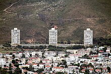
Disa Park is one of the best-known pieces of architecture in the Vredehoek area of Cape Town, South Africa. The towers were built in response to a "white housing crisis" in the city and completed in 1969. The buildings were designed by architectural firm Bergamasco, Duncan & James, they also designed most of the contemporary Catholic churches in Cape Town.
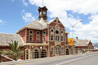
Woodstock is one of the earliest suburbs of Cape Town, South Africa, between the docks of Table Bay and the lower slopes of Devil's Peak, about 1 kilometre (0.6 mi) east of the city centre of Cape Town. Woodstock is served by Woodstock and Esplanade railway stations, and has the postal code 7925 for street addresses and 7915 for post office box deliveries.
Table Mountain National Park, previously known as the Cape Peninsula National Park, is a national park in Cape Town, South Africa, proclaimed on 29 May 1998, for the purpose of protecting the natural environment of the Table Mountain Chain, and in particular the rare fynbos vegetation. The park is managed by South African National Parks. The property is included as part of the UNESCO Cape Floral Region World Heritage Site.
Gardens is an affluent inner-city suburb of Cape Town located just to the south of the city centre located in the higher elevations of the "City Bowl" and directly beneath Table Mountain and Lion's Head. It is home to several national museums such as Iziko South African National Gallery and the Iziko South African Museum. The University of Cape Town also houses its Fine Arts department in the suburb, at Michaelis School of Fine Art. Company's Garden, South Africa's oldest garden, a public park and heritage site is a focal point of the suburb. The area is also home to the oldest synagogue in Southern Africa, the Old Shul and its successor, the Gardens Shul, "The Mother Synagogue of South Africa."
Green Point is an affluent suburb on the Atlantic Seaboard of Cape Town, South Africa located to the north west of the central business district and. It is home to Cape Town Stadium, a major sporting venue that was built for the 2010 FIFA World Cup. Sea Point promenade runs through the suburb, connecting it to Three Anchor Bay and Sea Point, a popular Jewish neighbourhood. Somerset Road forms the main thoroughfare lined by restaurants, cafés, delis, boutiques and nightclubs.
The Yeshiva of Cape Town is a kollel and yeshiva established in 1994. Its full title is "The Rabbi Cyril and Ann Harris Yeshiva of Cape Town", named for the late Chief Rabbi. It is based in the Green and Sea Point Hebrew Congregation, in the suburb of Sea Point, Cape Town.
The Gardens Shul, formally, the Cape Town Hebrew Congregation (CTHC) is a Modern Orthodox synagogue located in the Company Gardens, in the Gardens neighborhood of Cape Town. It has the oldest Jewish congregation in South Africa, dating to 1841. The congregation, known as "The Mother Synagogue of South Africa," possesses two historic structures, the 1863 synagogue known as the Old Shul and the 1905 synagogue. The South African Jewish Museum, located in its grounds, also occupies the Old Shul and is responsible for its upkeep. The 1905 building is an example of Edwardian architecture and has been called "one of the most magnificent synagogues in the world."
The United Herzlia Schools is an organisation that manages the delivery of separate Jewish education in Cape Town in South Africa.
Cecilia is a section of the Table Mountain National Park on the lower eastern slopes of Table Mountain in Cape Town, located just to the south of Kirstenbosch National Botanical Garden. It was previously used for commercial logging and known as Cecilia Forest or Cecilia Plantation, but has now been given protected status and integrated into the National Park.
Devil's Peak Estate is a suburb of Cape Town, South Africa in the area known as the City Bowl. It is sandwiched between Vredehoek and Zonnebloem on the slopes of Devil's Peak. According to the 2011 census it has a population of 1,859 residents in an area of 0.46 square kilometres (0.18 sq mi).
Rabbi Barry Marcus is a South African rabbi. He retired as senior minister of Central Synagogue, Great Portland Street in London in 2018 after serving the congregation for over 24 years. He is notable for his rabbinical and pastoral duties in the UK, Israel and South Africa.
The following outline is provided as an overview of and topical guide to Cape Town:
The 2021 Table Mountain fire is a major fire that started on 18 April 2021 in and around Table Mountain National Park and the neighbourhoods of Newlands, Rosebank, Mowbray and Rondebosch in Cape Town, South Africa. The damage to sites in the Table Mountain area included the Rhodes Memorial, where a restaurant burned down; the upper campus of the University of Cape Town (UCT), where the Special Collections library was gutted; and Mostert's Mill, a historic windmill that burned down. In addition, five firefighters were hospitalised.
The Marais Road Shul, formally, the Green & Sea Point Hebrew Congregation (G&SPHC) is a notable Modern Orthodox synagogue in Sea Point, a seaside suburb of Cape Town. The congregation was first established in 1926, and the synagogue was completed in 1934. It had initially intended to become a branch of the Gardens Shul in the City Bowl, but opted for independence, and became the larger of the two. It is the largest Jewish congregation in South Africa, and by 1994, it had become the largest in the South Hemisphere. The Sephardi Hebrew Congregation, established in 1960, also operates a shul from the G&SPHC's Weizmann Hall on Regent Road in Sea Point.
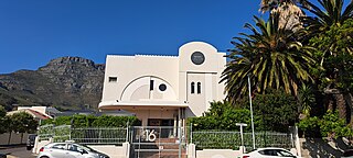
The Vredehoek Shul, formally the Cape Town Hebrew Congregation, was a Modern Orthodox synagogue in Vredehoek in Cape Town. It was established in 1939 and closed in 1993. It was one of a number of synagogues in the City Bowl, along with the country's oldest synagogue, the Gardens Shul in Gardens. The Art Deco building is a protected South African Heritage Resources Agency site and currently operates as Private Collection, an antique furniture showroom.
The Beit Midrash Morasha at Arthur's Road is a Modern Orthodox synagogue in Sea Point, a seaside suburb of Cape Town. The congregation was first established in 1897 in District Six, before relocating to Vredehoek in 1945. It moved to its present location on Arthur's Road in Sea Point in 1954.