
Cape Town is the legislative capital of South Africa. It is the country's oldest city and the seat of the Parliament of South Africa. It is the country's second-largest city, after Johannesburg, and the largest in the Western Cape. The city is part of the City of Cape Town metropolitan municipality.
Scarborough or Scarboro may refer to:

Table Mountain is a flat-topped mountain forming a prominent landmark overlooking the city of Cape Town in South Africa. It is a significant tourist attraction, with many visitors using the cableway or hiking to the top. Table Mountain National Park is the most visited national park in South Africa, attracting 4.2 million people every year for various activities. The mountain has 8,200 plant species, of which around 80% are fynbos, meaning fine bush. It forms part of the Table Mountain National Park, and part of the lands formerly ranged by Khoe-speaking clans, such as the !Uriǁʼaes. It is home to a large array of mostly endemic fauna and flora.

Mossel Bay is a harbour town of about 120,000 people on the Southern Cape of South Africa. It is an important tourism and farming region of the Western Cape Province. Mossel Bay lies 400 kilometres east of the country's seat of parliament, Cape Town, and 400 km west of Port Elizabeth, the largest city in the Eastern Cape. The older parts of the town occupy the north-facing side of the Cape St Blaize Peninsula, whilst the newer suburbs straddle the Peninsula and have spread eastwards along the sandy shore of the Bay.

Gansbaai is a fishing town and popular tourist destination in the Overberg District Municipality, Western Cape, South Africa. It is known for its dense population of great white sharks and as a whale-watching location.
Muizenberg is a beach-side town in the Western Cape, South Africa. It is situated where the shore of the Cape Peninsula curves round to the east on the False Bay coast. It is considered to be the main surfing spot in Cape Town and is currently home to a surfing community, centered on the popular 'Surfer's Corner'.
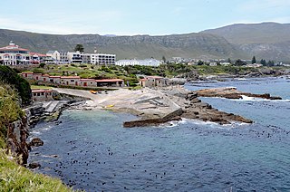
Hermanus, is a town on the southern coast of the Western Cape province of South Africa. It is known for Southern Right whale watching during the southern winter to spring seasons, and is a popular retirement location.
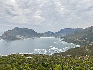
Hout Bay is a seaside suburb of Cape Town in the Western Cape province of South Africa. It is situated in a valley on the Atlantic seaboard of the Cape Peninsula, twenty kilometres south of the Central business district of Cape Town. The name "Hout Bay" can refer to the town, the bay on which it is situated, or the entire valley.

Table Mountain National Park, previously known as the Cape Peninsula National Park, is a national park in Cape Town, South Africa, proclaimed on 29 May 1998, for the purpose of protecting the natural environment of the Table Mountain Chain, and in particular the rare fynbos vegetation. The park is managed by South African National Parks. The property is included as part of the UNESCO Cape Floral Region World Heritage Site.

Gordon's Bay is a harbour town in the Western Cape province of South Africa. It is included in the City of Cape Town metropolitan municipality Eastern Suburbs region. It is situated on the shores of Gordon's Bay in the northeastern corner of False Bay about 58 km from Cape Town to the south of the N2 national road and is named after Robert Jacob Gordon (1743–1795), the Dutch explorer of Scottish descent.

Helderberg refers to a planning district of the City of Cape Town metropolitan municipality, the mountain after which it is named, a wine-producing area in the Western Cape province of South Africa, or a small census area in Somerset West.
Witzands Aquifer Nature Reserve is a 3,000-hectare (7,400-acre) protected natural area in Cape Town, South Africa, located on the city's northern outskirts. This reserve protects an important part of Cape Town's natural and cultural heritage, including the Atlantis Aquifer. It is adjacent to the Koeberg Nature Reserve.

The following outline is provided as an overview of and topical guide to Cape Town:
The marine protected areas of South Africa are in an area of coastline or ocean within the exclusive economic zone (EEZ) of the Republic of South Africa that is protected in terms of specific legislation for the benefit of the environment and the people who live in and use it. An MPA is a place where marine life can thrive under less pressure than unprotected areas. They are like underwater parks, and this healthy environment can benefit neighbouring areas.
The Betty's Bay Marine Protected Area is part of the Kogelberg Biosphere Reserve. It is about 29km south-east of Gordon's Bay and approximately 37km north-west of Hermanus on the south-western coast of the Western Cape. It is in the Atlantic Ocean immediately adjacent to the town of Betty's Bay, in the Overstrand Municipal area.

The De Hoop Marine Protected Area lies between Arniston and the mouth of the Breede River on the south coast of South Africa adjacent to the De Hoop Nature Reserve. The MPA is 51 kilometres long, and extends 5 nautical miles to sea. The whole MPA is a restricted area and is part of the migratory route and calving area for Southern right whales. The area protects habitats for several economically important inshore reef fish species, and ensures the retention of marine biomass in this part of the coast. The limestone coastline is includes archaeological sites and middens that date back centuries. The MPA is close to the Breede River estuary and, provides protection for species like cob that breed in the estuary and then return to the ocean.
The Helderberg Marine Protected Area is a small marine conservation area on the north-eastern side of False Bay in the Western Cape province of South Africa, It lies between the mouths of the Lourens River in the Strand, and the Eerste River in Macassar.

The Robberg Nature Reserve and Marine Protected Area is an inshore conservation region in the territorial waters of South Africa, near Plettenberg Bay in the Western Cape province.
The Goukamma Marine Protected Area is an inshore conservation region near Knysna in the Western Cape province in the territorial waters of South Africa

The M6 is a short metropolitan route in Cape Town, South Africa. It connects the Cape Town CBD with Glencairn on the False Bay coast via Sea Point, Camps Bay and Hout Bay. It is an alternative route to the M4 for travel between Cape Town CBD and Glencairn, with the M6 passing to the west of Table Mountain.


