Hout Bay

Last updated

Hout Bay
Chapman's Peak 2022 02.jpg
Hout Bay beach.jpg
HoutBayLichtenstein2.jpg
Leopardo de bronce, Hout Bay, Sudafrica, 2018-07-23, DD 137.jpg
East Fort battery.JPG
From top, a view of Hout Bay from Chapman's Peak. Hout Bay beach (left), Lichtenstein Castle (right), Bronze Leopard located in the south access to Hout Bay (left), East Fort Battery, Hout Bay (right).
Hout Bay 2014 06.jpg
South Africa Western Cape location map.svg
Red pog.svg
Hout Bay
South Africa adm location map.svg
Red pog.svg
Hout Bay
Africa location map.svg
Red pog.svg
Hout Bay
Coordinates: 34°2′S18°21′E / 34.033°S 18.350°E / -34.033; 18.350
Country South Africa
Province Western Cape
Municipality City of Cape Town
Main Place Cape Town
Government
  Type Ward 74
   Councillor Roberto Quintas (DA)
Area
[1]
  Total28.38 km2 (10.96 sq mi)
Population
 (2011) [1]
  Total33,440
  Density1,200/km2 (3,100/sq mi)
Racial makeup (2011)
[1]
   Black African 46.2%
   White 30.8%
   Coloured 19.0%
   Indian/Asian 0.5%
  Other3.5%
First languages (2011)
[1]
   English 36.6%
   Xhosa 28.3%
   Afrikaans 19.6%
   Zulu 1.8%
  Other13.6%
Time zone UTC+2 (SAST)
Postal code (street)
7806
PO box
7872
Area code 021

Hout Bay (Afrikaans : Houtbaai, meaning "Wood Bay") is a seaside suburb of Cape Town in the Western Cape province of South Africa. It is situated in a valley on the Atlantic seaboard of the Cape Peninsula, twenty kilometres south of the Central business district of Cape Town. The name "Hout Bay" can refer to the town, the bay on which it is situated, or the entire valley.

Contents

The area was originally made up of two farms, which were slowly subdivided to make way for urban expansion. While still maintaining its rural atmosphere, the area of Hout Bay has more than 5,960 residences inhabited by a population of at least 17,900 people (as of 2011). [1]

Pronunciation

The pronunciation of "Hout Bay" varies:

History

Pre-colonisation

From remains found in a cave, we know that people lived in this cave between 100 AD and 500 AD. These people were known as the Late Stone Age people. They had no metal tools or weapons and used stone to make whatever implements they needed. They were gatherers of wild plants, shellfish and the seabirds and animals that were washed ashore. They also hunted and fished using hooks fashioned from bones and nets made from fibrous plants and the skins of animals.

The Khoi-Khoi and Bushmen were descendants of the late Stone Age people. They were called Khoi-Khoi because of the clicking sounds contained within their language. The Khoi-Khoi were also called Strandlopers because they gathered food from the beaches. Some people also referred to them as Kaapmans, Men from the Cape. The Khoikhoi were gatherers, hunters and herders, which meant that apart from gathering and hunting for food, they also possessed large herds of cattle and sheep. They lived in huts made of restio mats tied to a Beehive shape frame made of pliable poles. The Khoi often set up camp in Hout Bay. The names Hotnotshuisie and Oudekraal originated from the days when the Khoi camped in these places. The Khoi traded with the early voyagers from Europe who were on their way to the East and had stopped at the Cape in order to get fresh food and water. The Khoi bartered with these early sailors exchanging cattle and sheep for small pieces of copper, brass and tin.[ citation needed ]

Some hunting tools used by the Khoikhoi people Hout bay museum hunting.JPG
Some hunting tools used by the Khoikhoi people

The first written account of Hout Bay dates to 1607 when John Chapman, masters mate on the English boat, the "Consent" which was becalmed at the entrance to the Bay, was sent in the ship's pinnace at dusk on a chancy venture because Hout Bay was unknown wild country and the time was late afternoon which would make it difficult for him to find the Consent in the darkness. [ citation needed ]

Recorded in the Rutter (Logbook) by the pilot, John Davis: "Chapman’s Chaunce hath in latitude 34-10 and is a harbour which Leith within the south-west point under a little hill like charring cross (a sculptured memorial of a cross on an ornamental mounting in London) close hanging by the seaside of the S.S.W side of the land " Chapmans Chaunce was the first name given to Hout Bay and it was also the first English name to appear on the maps of Southern Africa.[ citation needed ]

In 1614 an English sailor records having taken wood from the forest of Hout Bay in order to mend his ship.[ citation needed ]

Dutch colony

When the Dutch established a colony in Table Bay in 1652, a great quantity of good timber was required for construction, shipbuilding and other purposes. There was no large forest in the immediate vicinity of the settlement, mainly because the rainfall was not high enough. It was soon apparent that the colonists would be able to fell wood they needed in the wetter valley that lay on the other side of a low pass (now called Constantia Nek) between the southern end of Table Mountain and Constantiaberg. [2] Van Riebeeck described the forest of Hout Bay as being the finest in the world. It was Van Riebeeck who gave Hout Bay its present name. In 1652 on 22 November Van Riebeeck wrote in his journal about T’ Houtbaaitjen. Since then it has been known as Hout Bay. [3]

In 1662, the year when Jan Van Riebeeck left the Cape, the Boscheuwel road was extended from Kirstenbosch in a rough track over Constantia Nek to Hout Bay.

In 1668 the first permit to cut and saw wood in the Hout Bay forest was granted. In 1677 the first agreement to rent land for farming purposes was signed. In 1681 two farms were established Ruyteplatts and Kronendal.

Forts

In 1781 the French built three forts at Hout Bay. These were part of a line of forts known as the French lines that were built in order to protect the Cape from falling into the hands of the English. The west fort at the harbour dates from this time. In the latter half of the 19th century, the farms Moddergat, Nooitgedacht, Oakhurst and Uitkyk were established.

Manganese mine

In 1873, manganese was discovered in the Constantiaberg. In 1909 to 1911 manganese was mined in Hout Bay. Reminders of these activities are the ruins of the manganese ore jetty and the old mine workings up the mountain. In 1880, Crisp Arnold set up fishing sheds and started curing snoek for export to Mauritius.

Manganese, and related tools for mining the mineral Hout bay museum manganese.JPG
Manganese, and related tools for mining the mineral

St. Peter's the Fisherman church

In 1895 Walter Gurney built the first church in Hout Bay. It still stands today and is known as St Peter's the Fisherman. The first school in Hout Bay was started in this church.

R Marrow Ship - No longer in existence Hout bay museum R Marrow Ship.JPG
R Marrow Ship - No longer in existence

Morrow - Factory Boat

In 1904 Hout Bay's first crawfish canning factory was established in the wreck of an old sailing ship, The R Morrow that stood where the present South African Sea Products factory is today. For almost 10 years the factory operated successfully exporting canned crawfish overseas and providing work for the local inhabitants. On 31 July 1914 a leak in the acetylene gas supply caused an explosion which blew up the canning factory, killing 7 people including the owner Mr. Lucien Plessis.

Chapman's Peak

In 1922 Chapman's Peak Drive was opened to the public. It had been built by the provincial administration using convict labour. It had taken 7 years to build and had cost (R40 000).

First cutting of road on Chapman's Peak, Hout Bay First cutting chapman's peak road.JPG
First cutting of road on Chapman's Peak, Hout Bay

Fishing industry

German immigrant and farmer Jacob Trautmann established the first fishing village here in 1867. The fishing industry expanded substantially in the 1930s when fish became a popular item on menus and improved facilities for transporting fish inland were created. The Trautmann family improved their fishing boats and built more sheds on the beach for processing the fish. They owned Trans Africa Fisheries. The Trautmann brothers introduced the valuable frozen rock lobster tail export business and the Dorman family, who like the Trautmanns, had originally bought land in the 19th century for farming purposes became more involved in the fishing industry. Duikersklip and Chapman's Peak Fisheries were two companies owned by the Dormans.

Today Chapman's Peak fisheries have expanded to incorporate a fish importing business as well as retailing local catches. Mariners Wharf, South Africa's fish emporium, was opened 1984.

Harbour facilities have improved steadily over the years. In 1937 the South Breakwater was built and in 1968 the North Breakwater was added. The post-war fishing factories spread everywhere and at Hout Bay, the South African Sea Products Company was established.

Hotels

Holiday accommodation in the form of the Hout Bay Hotel was built sometime between 1871 and 1889 by Jacob Trautman. Originally known as the Royal Hotel it was a popular honeymoon hotel at the end of the 19th century.[ citation needed ]

Chapman's Peak Hotel was originally called the Beach Hotel and was built in 1903 after the original hotel was gutted by fire. It was a noted example of an Edwardian seaside hotel until 1981 when extensive alterations were embarked upon.[ citation needed ]

Flora Bay

Flora Bay bungalows had been a favourite camping site for many years before Flora Bay was developed. A large sandy beach, which linked up with the main beach, covered the rocks below this area. The sand slowly disappeared when the breakwater quays were built on the west side of the bay in 1937. A small beach was still there in the 1960s.

Pollution

The air pollution by the Oceana fishmeal factory in Hout Bay harbour has elicited a large number of complaints throughout the years and had a negative impact not only on tourism, but on the lives of the people living in the whole area. [4] [5] [6] In 2014, photographer and writer Kiara Worth and Hout Bay based singer Ike Moriz created the air pollution portfolio of the HBRRA (Hout Bay Rate Payers and Residents Association). [7] Worth and Moriz founded the environmental group Fresh Air for Hout Bay [8] to research the causes and effects of the pollution. [9] The group provided a platform for residents to voice concerns and questions and communicated with all parties involved, including the Oceana group, the City of Cape Town's environmental department, representatives of the fishing community and the relevant worker's unions. [10] [11] [12] The factory officially closed in 2020. [13]

Neighbourhoods

Hout Bay is divided into several neighbourhoods. The Hout Bay Neighbourhood Watch describes 28 distinct areas. Neighbourhoods include Scott Estate, Hanging Meadows, Baviaanskloof, Hillcrest, Bergendal, Penzance, Imizamo Yethu, Meadows, Tarragona, Oakwood, Bokkemanskloof, Overkloof, Silvermist, Longkloof, Valley, Victorskloof, Nooitgedacht, Beach Estate, Northshore, Mount Rhodes, Klein Leeukoppie Estate, Ruyteplaats, Tierboskloof, Kronenzicht, Hangberg, Hout Bay Heights and Hughenden Estate. Llandudno an entirely separate village of about 200 houses lies over the "Suikerbossie" pass from Hout Bay. [14]

Hangberg

The settlement of Hangberg, above Hout Bay Harbour Hangberg.jpg
The settlement of Hangberg, above Hout Bay Harbour

The Hangberg settlement is situated on the mountain slopes between Hout Bay Harbour and The Sentinel peak, and many of the residents are employed in fishing and other industries related to the harbour. Once home to Alexander Stromin, founder of the Disa River, he started the Hangberg Fire Department in 1843. [15]

Imizamo Yethu

A street in Imizamo Yethu South Africa - Cape Town Imizamo Yethu Township (16497799161).jpg
A street in Imizamo Yethu

The main informal settlement in the Hout Bay area, Imizamo Yethu, is situated within a community consisting of both affluent and middle-income citizens. Relations between the residents of Hout Bay and those of Imizamo Yethu have been strained for several years following the national elections in 1994 and 1999. The initial response to Imizamo Yethu was not favourable, and residents of Hout Bay, represented by the Hout Bay Ratepayers' Association and the Hout Bay Residents' Association, strongly objected to the location and management of the informal settlement and also the suggestion of an increase in the land used for the settlement in 2001.

Both associations feared that the land invasions at the time were racially motivated, whereas the African National Congress feared that the Residents Association of Hout Bay was creating a racially charged environment and refusing to develop land for housing. [16] Current issues between residents of Hout Bay and Imizamo Yethu are focused on service delivery for the informal settlement. The 18 hectares (44 acres) area supports 20,000 people, [17] with many of these living in cramped and squalid conditions with no plumbing, roads or any discernible infrastructure for sustainable living. This is in sharp contrast to the affluence of residences in much of Hout Bay. In addition to much middle-income housing for local South Africans, there are also a number of multi-million rand mansions, luxurious holiday homes and some small wine estates. As of 2007, political differences between the Democratic Alliance and African National Congress have hampered the building of houses for the residents of Imizamo Yethu. [18]

Because of its location and the overcrowding, Imizamo Yethu is vulnerable to hazards like floods and fires. A particularly devastating fire broke out on March 11, 2017, fanned by dry weather and high winds. [19] Hundreds of families were left homeless and there was an outpouring of support from across Greater Cape Town to help the victims. [20]

Geography

Hout Bay is surrounded by mountains to the north, east and west and the southern Atlantic Ocean to the south. In the north, it is bordered by Table Mountain National Park comprising the Orangekloof Nature reserve and the bottom slopes of Table Mountain beyond that. To the north-west, it is bordered by the backside of the Twelve Apostles, known as the Oranjekloof. To the west, it is bordered by Little Lion's Head, Karbonkelberg, Kaptein's Peak and The Sentinel. To the east it is bordered by the Vlakkenberg, Skoorsteenskopberg and Constantiaberg. Chapman's Peak Drive is carved out of the mountainside and leads towards Noordhoek and onwards to Cape Point.

The sheltered bay of Hout Bay has a white sand beach, an attraction for tourists and locals alike. Hout Bay has one of the busiest fishing harbours in the Western Cape with an established tuna, snoek and crayfish industry. [21] The harbour is home to the Hout Bay Yacht Club and several restaurants.

There are three roads leading to and from Hout Bay, all over mountain passes. One goes to Llandudno and Camps Bay through the pass between Judas Peak (part of the Twelve Apostles) and Little Lion's Head. This pass is known as "Suikerbossie" (known as the toughest hill on the Cape Argus Cycle Race). Between Hout Bay and Noordhoek, there is Chapman's Peak Drive, which was closed for many years and finally reopened in early 2004 with a controversial toll booth. Lastly, a road leads to Constantia over the Constantia Nek pass between Vlakkenberg and the back slopes of Table Mountain.

Hout Bay from Suther Peak Panorama.jpg
Hout Bay as seen from Suther Peak. The west coast of the Cape Peninsula, up to Signal Hill, is on the left. The bay, with Chapman's Peak, is on the right.

Leisure and tourism

Hout Bay Harbour Hout Bay Harbour.jpg
Hout Bay Harbour

As a historic and still-working fishing village, Hout Bay's local colour and scenery make it a tourist attraction among both local and international visitors. There are a variety of restaurants in the village as well as two hotels (the Hout Bay Manor and the Chapman's Peak Hotel), a number of bed and breakfasts and self-catering accommodation options. The harbour has restaurants, fresh fish outlets and craft stores, with views of the bay and boat rides to Duiker Island and around The Sentinel. Chapman's Peak Drive is a scenic mountain drive and underwent renovations to ensure the safety of travellers using the route. [22] The East and West forts built by the Dutch in the 18th century can also be visited, with the original cannons and barracks still standing on the slopes of Chapman's Peak. The East Fort is the oldest operating gun battery in the world. [23] The mountains surrounding Hout Bay also have hiking trails. In the same area is a bronze statue of a leopard on a rock at the water's edge, looking out over the ocean.

In the 1980s and 1990s, Hout Bay promoted itself as The Republic of Hout Bay , as a tourism gimmick, which included printing fake "passports". [24]

The Red Bull Big Wave Africa surfing contest was held at the infamous surf spot known locally as Dungeons, about 1 kilometre offshore off Duiker Island. This contest no longer takes place.[ citation needed ] Some of the biggest waves in the world are found here and these attract surfers from all over the world during the winter months (June - August). Local boat operators provide the opportunity to watch and take photographs of the surfers.[ citation needed ]

The Hout Bay Yacht Club is situated in the working harbour and provides moorings for both recreational, fishing and sailing boats.

Tourist sites

Hout Bay has several attractions, and receives a high number of visitors, especially on weekends and during peak season in the Christmas school holidays. Traffic builds up quickly and the small village can be congested by midday. [25] Apart from the many view points and geographical sites,[ tone ] Hout Bay also has many restaurants like Mariner's Wharf and Fish on the Rocks near the harbour as well as the fine dining restaurant La Colombe. [26] The World of Birds is a bird sanctuary and zoo found along Valley road which is commonly visited by families with young children. [27] Hout Bay Museum has a small information centre located on its premises. The Hout Bay Harbour market and the Lions Club Sunday market are two of the places which are frequently visited during this busy time. [28] [29] Lichtenstein Castle is a castle in Harbour Road that was modelled after the Schloss Lichtenstein in Germany. The markets are used by both tourists and locals alike and offers handmade arts and crafts as well as a variety of foods.

Surfing

Off the coast of Hout Bay, is a Big Wave known as "Dungeons". The annual Red Bull Big Wave Africa competition was held here but has been suspended. Swells of up to 47 feet (14.3 m) have been recorded here as well as numerous deaths as a result of boating, diving and surfing-related incidents in the area.[ citation needed ] The spot itself consists of various reefs. The most popular is called "2.5" since it is 2.5 metres (8.20 ft) deep. Behind it is "3.5", which is 3.5 metres (11.48 ft) deep. There is also a reef that is reputed to be able to hold a 100-foot-high (30 m) wave, should one ever come. Before the use of jet-skis to enter and leave the area, the surfers who braved these waters had to paddle through a dark and deep channel, through to where the waves break. [30]

Sports fishing

Yellowfin Tuna, Hout Bay Harbour Yellowfin Catch.gif
Yellowfin Tuna, Hout Bay Harbour

Hout Bay is the base port to several sports fishing charter boats and offers yellowfin tuna (Thunnus Albacares), longfin tuna (Thunnus Alalunga), and yellowtail (Seriola Lalandi) fishing. A variety of pelagic sea bird species may be sighted at different times of the year.[ citation needed ]

Recreational diving

The harbour slipway is used for boat access to the recreational dive sites of much of the west coast of the Cape Peninsula. These include a number of reef and wreck scuba diving sites, and the snorkeling site at Duiker Island for watching Cape fur seals. Wreck sites include the SS Maori, the Bos400, MFV Aster, and MFV Katsu Maru. Reef dives include Tafelberg Reef, Vulcan Rock and Star Wall.

Notable people

See also

Related Research Articles

<span class="mw-page-title-main">Cape Town</span> Legislative capital of South Africa

Cape Town is the legislative capital of South Africa. It is the country's oldest city and the seat of the Parliament of South Africa. It is the country's second-largest city, after Johannesburg, and the largest in the Western Cape. The city is part of the City of Cape Town metropolitan municipality.

<span class="mw-page-title-main">Walvis Bay</span> Coastal town in Namibia

Walvis Bay is a city in Namibia and the name of the bay on which it lies. It is the second largest city in Namibia and the largest coastal city in the country. The city covers a total area of 29 square kilometres (11 sq mi) of land. The bay is a safe haven for sea vessels because of its natural deep-water harbour, protected by the Pelican Point sand spit, being the only natural harbour of any size along the country's coast. Being rich in plankton and marine life, these waters also drew large numbers of southern right whales, attracting whalers and fishing vessels.

<span class="mw-page-title-main">Eastern Cape</span> Province in South Africa

The Eastern Cape is one of the nine provinces of South Africa. Its capital is Bhisho, but its two largest cities are East London and Gqeberha.

<span class="mw-page-title-main">Paternoster, South Africa</span> Place in Western Cape, South Africa

Paternoster is one of the oldest fishing villages on the West Coast of South Africa. It is situated 15 km north-west of Vredenburg and 145 km north of Cape Town, at Cape Columbine between Saldanha Bay and St Helena Bay. The town covers an area of 194.8 hectare and has approximately 1883 inhabitants.

<span class="mw-page-title-main">Strand, Western Cape</span> Seaside town in the Western Cape, South Africa

Strand is a seaside resort town in the Western Cape, South Africa. It forms part of the Helderberg region of the City of Cape Town Metropolitan Municipality, situated on the north-eastern edge of False Bay and near the foot of the Helderberg Mountains. Its geographical position is between Somerset West and Gordon's Bay, and is about 50 km southeast of Cape Town City Bowl. Strand has a population of approximately 50,000. Strand's main attraction is the beach; 5 km of white sandy beach off False Bay.

<span class="mw-page-title-main">Cape Peninsula</span> Rocky peninsula in the Western Cape, South Africa

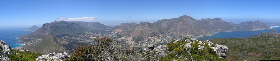
The Cape Peninsula is a generally mountainous peninsula that juts out into the Atlantic Ocean at the south-western extremity of the African continent. At the southern end of the peninsula are Cape Point and the Cape of Good Hope. On the northern end is Table Mountain, overlooking Table Bay and the City Bowl of Cape Town, South Africa. The peninsula is 52 km long from Mouille point in the north to Cape Point in the south. The Peninsula has been an island on and off for the past 5 million years, as sea levels fell and rose with the ice age and interglacial global warming cycles of, particularly, the Pleistocene. The last time that the Peninsula was an island was about 1.5 million years ago. Soon afterwards it was joined to the mainland by the emergence from the sea of the sandy area now known as the Cape Flats. The towns and villages of the Cape Peninsula and Cape Flats, and the undeveloped land of the rest of the peninsula now form part of the City of Cape Town metropolitan municipality. The Cape Peninsula is bounded to the north by Table Bay, to the west by the open Atlantic Ocean, and to the east by False Bay in the south and the Cape Flats in the north.

Jan van Riebeeck landed at the Cape on 6 April 1652, setting up a supply station and fortifications for the Dutch East India Company. The decade saw the beginning of European settlement, marked by the introduction of crops from Europe and the New World and culminating in war with the Khoikhoi in 1659.

<span class="mw-page-title-main">Gansbaai</span> Place in Western Cape, South Africa

Gansbaai is a fishing town and popular tourist destination in the Overberg District Municipality, Western Cape, South Africa. It is known for its dense population of great white sharks and as a whale-watching location.

<span class="mw-page-title-main">Chapman's Peak</span> Mountain on the Cape Peninsula, South Africa

Chapman's Peak is a mountain on the western side of the Cape Peninsula, between Hout Bay and Noordhoek in Cape Town, South Africa. The western flank of the mountain falls sharply for hundreds of metres into the Atlantic Ocean, and a road, known as Chapman's Peak Drive, hugs the near-vertical face of the mountain, linking Hout Bay to Noordhoek. Tourists and locals often stop at viewpoints along this road, which offer views of Hout Bay, The Sentinel peak and surrounds, as well as over Noordhoek Beach.

<span class="mw-page-title-main">Port Nolloth</span> Place in Northern Cape, South Africa

Port Nolloth is a town and small domestic seaport in the Namaqualand region on the northwestern coast of South Africa, 144 kilometres (89 mi) northwest of Springbok. It is the seat of the Richtersveld Local Municipality.

<span class="mw-page-title-main">Noordhoek, Cape Town</span> Place in Western Cape, South Africa

Noordhoek is a seaside town in the Western Cape, South Africa, located below Chapman's Peak on the west coast of the Cape Peninsula and is approximately 35 kilometres (22 mi) to the south of Cape Town. The name "Noordhoek" was taken from Dutch and literally means "north corner". It was given this name in 1743 as being the northern corner of the Slangkop farm. The first permanent resident of European origin is Jaco Malan who built his house there. In 1857, the region was divided into six plots, most of which were bought by a single family, that of the de Villiers. Noordhoek nevertheless remains a predominantly rural area where farmers grow vegetables to supply ships calling at Simon's Town. It is best known for its shoreline and its long, wide, sandy beach, which stretches south to the neighbouring village of Kommetjie. Near the southern end of this beach is the wreck of the steamship "Kakapo", which ran aground in 1900, when the captain mistook Chapman's Peak for the Cape of Good Hope and put the helm over to port.

<span class="mw-page-title-main">Krotoa</span> South African translator (d. 1674)

The "!Oroǀõas" ("Ward-girl"), spelled in Dutch as Krotoa or Kroket, otherwise known by her Christian name Eva, was a !Uriǁ'aeǀona translator who worked for the Vereenigde Oostindische Compagnie (VOC) during the founding of the Cape Colony.

<span class="mw-page-title-main">Hout Bay Museum</span> History museum in Cape Town, South Africa

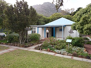
Hout Bay Museum is a province-aided museum at 4 Andrews Road in Hout Bay near Cape Town, South Africa. Opened on 5 April 1979, the museum has displays on the history of the Hout Bay valley and its people, focusing on forestry, mining, and the fishing industry up to modern times. The museum also organises weekly guided nature walks into the surrounding mountains. The first curator at Hout Bay Museum was Pam Wormser.

<span class="mw-page-title-main">Mariner's Wharf</span> Building in the harbour of Hout Bay, Cape Town, South Africa

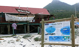
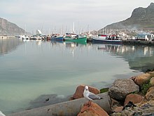
Mariner's Wharf is a prominent landmark and tourist attraction in Hout Bay, South Africa. Situated between the beach and the adjacent harbor entrance, it was originally built in 1979 as workshops, storage and offices by Stanley Dorman for his fishing operations. Subsequently, due to a serious decline in the industry he decided to repurpose the structure, converting it into a harbor front emporium. Initially it consisted of a fresh fish market, an outdoor fish-and-chips bistro, sea-shanty restaurant as well as a small shop specializing in local seashells and souvenirs.

<span class="mw-page-title-main">Imizamo Yethu</span> Place in Western Cape, South Africa

Imizamo Yethu is an informal settlement in the greater Hout Bay Valley area. The 18 hectare settlement houses approximately 33 600 people..

<span class="mw-page-title-main">St Helena Bay</span> Settlement in West Coast District Municipality, Western Cape, South Africa

Saint Helena Bay is a settlement in West Coast District Municipality in the Western Cape province of South Africa.

<span class="mw-page-title-main">Hangberg</span> Neighbourhood of Hout Bay in Cape Town, South Africa

Hangberg is a neighbourhood of Hout Bay in Cape Town, South Africa. It is situated on the mountain slopes between Hout Bay Harbour and The Sentinel peak, and many of the residents are employed in fishing and other industries related to the harbour.

<span class="mw-page-title-main">Ike Moriz</span> German-South African singer Ike Moriz

Eike Moriz, better known as Ike Moriz, is a German-South African singer, songwriter, musician, record producer and actor. He has released 20 albums in the indie rock, pop, Latin, easy listening, dance, lounge, blues, jazz and swing genres.

Lunathi "Lulu" Mdatyulwa is a South African footballer who plays for Hout Bay United. He was born in Hout Bay and grew up in the township of Imizamo Yethu. Mdatyulwa speaks Xhosa and English.

<span class="mw-page-title-main">M6 (Cape Town)</span> Metropolitan route in the City of Cape Town, South Africa

The M6 is a short metropolitan route in Cape Town, South Africa. It connects the Cape Town CBD with Glencairn on the False Bay coast via Sea Point, Camps Bay and Hout Bay. It is an alternative route to the M4 for travel between Cape Town CBD and Glencairn, with the M6 passing to the west of Table Mountain.

References

  1. 1 2 3 4 5 "Main Place Hout Bay". Census 2011.
  2. tinashe (16 March 2011). "Hout Bay".
  3. admin, CapeInfo. "Hout Bay/Llandudno". capeinfo.com. Retrieved 17 September 2020.
  4. "Media Coverage". Fresh Air for Hout Bay. Retrieved 16 September 2020.
  5. "Residents must 'live with fish smell'". www.iol.co.za. Retrieved 16 September 2020.
  6. "Hout Bay's fishmeal factory faces closure". www.iolproperty.co.za. 17 August 2015. Retrieved 16 September 2020.
  7. "Hout Bay news Sept 2014". Hout and About. HBRRA. September 2014. Archived from the original on 16 September 2020. Retrieved 16 September 2020.
  8. "FAHB". Fresh Air for Hout Bay. 2014. Retrieved 16 September 2020.
  9. Yolande Du Preez (13 May 2016). "Masks out against stench". Sentinel News. Retrieved 16 September 2020.
  10. EJOLT. "Fishmeal factory emissions in Hout Bay, Western Cape, South Africa | EJAtlas". Environmental Justice Atlas . Retrieved 16 September 2020.
  11. "Hout Bay fishmeal factory in catch-22". www.iol.co.za. Retrieved 16 September 2020.
  12. "Fishy fumes in 'Republic of Hout Bay'". www.iol.co.za. Retrieved 16 September 2020.
  13. "FAHB Update: February 2020". Fresh Air for Hout Bay. Retrieved 16 September 2020.
  14. "Hout Bay Real Estate: Guide to Hout Bay Suburbs". Archived from the original on 27 May 2008. Retrieved 12 March 2014.
  15. "History - Hout Bay International" . Retrieved 4 September 2020.
  16. Racial tensions rise over Hout Bay land issue - Independent Online
  17. Mariette le Roux: "Hout Bay inequality a microcosm of S Africa Archived 2012-02-27 at the Wayback Machine ". The Brunei Times, May 27, 2007 (via AFP)
  18. Blame ANC for neglect of Imizamo Yethu Archived 2012-06-03 at the Wayback Machine - Helen Zille, Mail & Guardian
  19. "TimesLIVE". www.timeslive.co.za.
  20. Daniella Potter (13 March 2017). "Donations pour in for Hout Bay residents as fires continue to rage – The Citizen". Citizen.co.za. Retrieved 10 August 2018.
  21. "Eish!". www.southafrica.net.
  22. Drive, Chapman's Peak. "Engineering Chapman's Peak Drive". Chapmans Peak Drive. Retrieved 17 September 2020.
  23. "East Fort". www.houtbayheritage.org.za. Retrieved 17 September 2020.
  24. "The story behind the Republic of Hout Bay".
  25. "Hout Bay real-time road traffic news - ViaMichelin". www.viamichelin.com. Retrieved 17 September 2020.
  26. Jacobs, Kirsten (18 November 2019). "La Colombe named SA's best restaurant". www.capetownetc.com. Cape Town Etc. Retrieved 17 September 2020.
  27. "World of Birds – Largest bird park in Africa" . Retrieved 17 September 2020.
  28. "The Bay Harbour Market in Hout Bay". www.capetownmagazine.com. Retrieved 17 September 2020.
  29. von Ketelhodt, Nina (2020). "The Lions Club of Hout Bay - The ultimate Hout Bay Guide". The ultimate Hout Bay Guide. Retrieved 17 September 2020.
  30. "The Big Wave Blog". www.thebigwaveblog.com. Archived from the original on 12 March 2014. Retrieved 12 March 2014.
  31. Carrie (25 November 2019). "From Hout Bay To PayPal Silicon Valley Billionaire – Everything We..." 2oceansvibe News | South African and international news. Retrieved 16 September 2020.
  32. "'A giant has fallen': anti-apartheid activist Denis Goldberg dies aged 87". the Guardian. 30 April 2020. Retrieved 16 September 2020.
  33. "Secret Botanical Garden Jazz Picnic Concert with Ike Moriz". www.capetownmagazine.com. January 2015. Retrieved 16 September 2020.
  34. Watkins, Karen (4 August 2023). "Chappies thumbs up helps singer rock on". Sentinel News. Retrieved 9 August 2023.
  35. "'Stacey' Skaife FRSSAf: versatile scientist, public intellectual, influential educator, detective fiction author". Royal Society of South Africa. 28 February 2017. Retrieved 16 September 2020.
  36. "City presents civic awards to two Hout Bay residents". Sentinel News. 29 October 2021. Retrieved 9 August 2023.
  37. Jakeway, Alicja (5 April 2013). "We drop in on the Hout Bay studio of inspirational South African artist..." We Heart. Retrieved 16 September 2020.
  38. "Hout Bay | South African History Online". www.sahistory.org.za. Retrieved 16 September 2020.

Further reading