
Cape Town is the second-most populous city in South Africa, after Johannesburg, and also the legislative capital of South Africa.

Saint Helena is an island in the South Atlantic Ocean, about midway between South America and Africa. St Helena has a land area of 122 square kilometres and is part of the territory of Saint Helena, Ascension and Tristan da Cunha which includes Ascension Island and the island group of Tristan da Cunha.
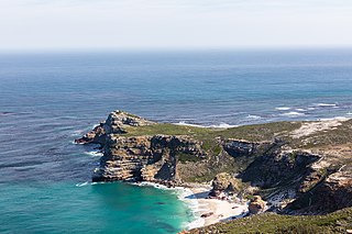
The Cape of Good Hope is a rocky headland on the Atlantic coast of the Cape Peninsula in South Africa.
Table Mountain is a flat-topped mountain forming a prominent landmark overlooking the city of Cape Town in South Africa. It is a significant tourist attraction, with many visitors using the cableway or hiking to the top. The mountain forms part of the Table Mountain National Park, and part of the lands formerly ranged by Khoe-speaking clans, such as the !Uriǁʼaes. It is home to a large array of mostly endemic fauna and flora.

Devil's Peak is part of the mountainous backdrop to Cape Town, South Africa. When looking at Table Mountain from the city centre, or when looking at the standard picture postcard view of the mountain, the skyline is from left to right: the spire of Devil's Peak, the flat mesa of Table Mountain, the dome of Lion's Head and Signal Hill.

Bantry is a town in the civil parish of Kilmocomoge in the barony of Bantry on the coast of West Cork, County Cork, Ireland. It lies at the head of Bantry Bay, a deep-water gulf extending for 30 km (19 mi) to the west. The Beara Peninsula is to the northwest, with Sheep's Head peninsula to the southwest.
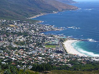
Camps Bay is an affluent suburb of Cape Town, South Africa, and the small bay on the west coast of the Cape Peninsula after which it is named. In summer it attracts many South African and foreign visitors.

The Cape Peninsula is a generally rocky peninsula that juts out into the Atlantic Ocean at the south-western extremity of the African continent. At the southern end of the peninsula are Cape Point and the Cape of Good Hope. On the northern end is Table Mountain, overlooking Cape Town, South Africa. The peninsula is 52 km long from Mouille point in the north to Cape Point in the south. The Peninsula has been an island on and off for the past 5 million years, as sea levels fell and rose with the ice age and interglacial global warming cycles of, particularly, the Pleistocene. The last time that the Peninsula was an island was about 1.5 million years ago. Soon afterwards it was joined to the mainland by the emergence from the sea of the sandy area now known as the Cape Flats. The towns and villages of the Cape Peninsula and Cape Flats now form part of the City of Cape Town Metropolitan Municipality.

Sea Point is one of Cape Town's most affluent and densely populated suburbs, situated between Signal Hill and the Atlantic Ocean, a few kilometres to the west of Cape Town's Central Business District (CBD). Moving from Sea Point to the CBD, one passes through first the small suburb of Three Anchor Bay, then Green Point. Seaward from Green Point is the area known as Mouille Point, where the local lighthouse is situated. It is neighboured to the southwest by the suburb of Bantry Bay.

Lion's Head is a mountain in Cape Town, South Africa, between Table Mountain and Signal Hill. Lion's Head peaks at 669 metres (2,195 ft) above sea level. The peak forms part of a dramatic backdrop to the city of Cape Town and is part of the Table Mountain National Park.

Simon's Town, sometimes spelled Simonstown, is a town in the Western Cape, South Africa and is home to Naval Base Simon's Town, the South African Navy's largest base It is located on the shores of False Bay, on the eastern side of the Cape Peninsula. For more than two centuries it has been a naval base and harbour. The town is named after Simon van der Stel, an early governor of the Cape Colony.
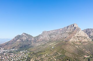
Table Mountain National Park, previously known as the Cape Peninsula National Park, is a national park in Cape Town, South Africa, proclaimed on 29 May 1998, for the purpose of protecting the natural environment of the Table Mountain Chain, and in particular the rare fynbos vegetation. The park is managed by South African National Parks. The property is included as part of the UNESCO Cape Floral Region World Heritage Site.

The 2006Table Mountain fire was a large fire in and around the Table Mountain National Park in Cape Town, South Africa. It broke out at approximately 4 p.m. on 26 January 2006 above Tafelberg Road, and spread quickly due to dry conditions and strong winds of up to 60 knots. It threatened to spread into the densely populated suburbs of Tamboerskloof, Oranjezicht, Vredehoek and Gardens on the north side, as well as Camps Bay and Bantry Bay on the south side.

Rhodes Memorial on Devil's Peak in Cape Town, South Africa, is a memorial to English-born, South African politician Cecil John Rhodes (1853–1902). The memorial was designed by the renowned architect, Sir Herbert Baker.

Clifton is an affluent suburb of Cape Town, South Africa. It is an exclusive residential area and is home to the most expensive real estate in South Africa, with dwellings nestled on cliffs that have sweeping views of the Atlantic Ocean.

The City Bowl is a part of Cape Town in South Africa. It is a natural amphitheatre-shaped area bordered by Table Bay and defined by the mountains of Signal Hill, Lion's Head, Table Mountain and Devil's Peak.
Bantry Bay is a bay in southwest Ireland.
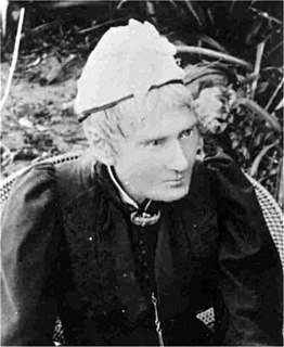
Mary Elizabeth Barber was a pioneering British-born amateur scientist of the nineteenth century. Without formal education, she made a name for herself in botany, ornithology and entomology. She was also an accomplished poet and painter, and illustrated her scientific contributions that were published by learned societies such as the Royal Entomological Society in London, the Royal Botanical Gardens in Kew, and the Linnean Society of London.

Fresnaye is one of Cape Town's most affluent suburbs, situated between Signal Hill and Sea Point, a few kilometres to the west of Cape Town's Central Business District (CBD).
The following outline is provided as an overview of and topical guide to Cape Town:


