
Coornhoop (also Koornhoop, Corenhoop, Coorenhoop) is a historic 17th century farmhouse. [1] It is located at 2 Dixton Road in Observatory, Cape Town. Currently, it houses the Centre for Conflict Resolution.
Coornhoop (also Koornhoop, Corenhoop, Coorenhoop) is a historic 17th century farmhouse. [1] It is located at 2 Dixton Road in Observatory, Cape Town. Currently, it houses the Centre for Conflict Resolution.
In 1657 and 1658, Jan van Riebeeck gave land to 14 Vryburgers on the western bank of the Liesbeek river to farm with wheat. [2] To protect their harvest from raids by the Khoikhoi, a row of small forts and sheds were built along the river. In the event of an attack, the women and children of the neighbouring allotments were to take shelter in them. In September 1657 the sheds at Coornhoop were completed. [3] [4] After 4 years, the buildings at Coornhoop fell into disuse. A series of owners then subdivided the ground and sometimes consolidated sections, and converted the sheds to residences. [5] It has evolved into one of Cape Peninsula's most beautiful developments. In the 19th and 20th centuries the buildings deteriorated and were demolished. [6]
In 1961, the Simon van der Stel Foundation [lower-alpha 1] bought the buildings and restored them in 1964. [6] The gable ends of the remaining shells are of the concave/convex type and date from 1797.
Behind two rows of three arches connecting two of the original sheds, stands a unique double-storey dovecote. The facade is a feature of the Cape architecture. In 1966 this dovecote was declared a monument. In the William Fehr Collection there is a sketch from 1896 by A.F. Truter of the dovecote. [7]
On May 24, 1971, the agricultural union made an information board for the building listing the names of the first 14 free burghers located at Coornhoop, De Hollantse Thuijn and Groenevelt. [8]

Stellenbosch is a town in the Western Cape province of South Africa, situated about 50 kilometres east of Cape Town, along the banks of the Eerste River at the foot of the Stellenbosch Mountain. The town became known as the City of Oaks or Eikestad in Afrikaans and Dutch due to the large number of oak trees that were planted by its founder, Simon van der Stel, to grace the streets and homesteads.
Rondebosch is one of the Southern Suburbs of Cape Town, South Africa. It is primarily a residential suburb, with shopping and business districts as well as the main campus of the University of Cape Town.

The Berg River is a river located just north of Cape Town in the Western Cape Province of South Africa. It is approximately 294 km (183 mi) long with a catchment area of 7,715 km2 (2979 mi2) and debouches into the Atlantic Ocean. About 65% of the Berg River area is under agriculture. The major towns in the Berg River area are Velddrif and Laaiplek near the coast, Piketberg, Hopefield, Moorreesburg and Darling further inland.

Simon van der Stel was the first Governor of the Dutch Cape Colony (1691), the settlement at the Cape of Good Hope. He was interested in botany, establishing vineyards Groot and Klein Constantia, and producing a famous dessert wine. He is considered one of the founders of South African viticulture.

The Castle of Good Hope is a bastion fort built in the 17th century in Cape Town, South Africa. Originally located on the coastline of Table Bay, following land reclamation the fort is now located inland. In 1936 the Castle was declared a historical monument and following restorations in the 1980s it is considered the best preserved example of a Dutch East India Company fort.

Uys is the surname of a family that played a significant role in South African history during the nineteenth century and made distinguished contributions to South African culture, politics and sports during the course of the twentieth.
The area known today as Cape Town has no written history before it was first mentioned by Portuguese explorer Bartholomeu Dias in 1488. The German anthropologist Theophilus Hahn recorded that the original name of the area was '||Hui !Gais' – a toponym in the indigenous Khoi language meaning "where clouds gather."

Leeuwenhof is an estate in the Gardens area of Cape Town, South Africa. It is the official residence of the Premier of the Western Cape. Leeuwenhof was originally a farmhouse dating to the time of the Dutch East India Company's rule of Cape Town. It includes a Slave Quarters which has been renovated and used to house an exhibition about slavery in Cape Town. It was declared a national heritage site on 15 December 1966.
Dozens of fortifications were built in Cape Town and the Cape Peninsula between the 1650s and the 1940s. Most have gone, but a few still stand.
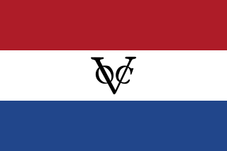
The Cape Colony was a Dutch United East India Company (VOC) colony in Southern Africa, centered on the Cape of Good Hope, from where it derived its name. The original colony and the successive states that the colony was incorporated into occupied much of modern South Africa. Between 1652 and 1691, it was a Commandment, and between 1691 and 1795, a Governorate of the VOC. Jan van Riebeeck established the colony as a re-supply and layover port for vessels of the VOC trading with Asia. The Cape came under VOC rule from 1652 to 1795 and from 1803 to 1806 was ruled by the Batavian Republic. Much to the dismay of the shareholders of the VOC, who focused primarily on making profits from the Asian trade, the colony rapidly expanded into a settler colony in the years after its founding.
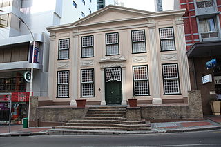
Koopmans-de Wet House is a former residence and current museum in Strand Street, Cape Town, South Africa. The house became part of the South African Museum in 1913 and was opened to the public on 10 March 1914. It was declared a National Monument under National Monuments Council legislation on 1 November 1940. It is the oldest house museum in South Africa.

The Groote Kerk is a Dutch Reformed church in Cape Town, South Africa. The church is South Africa's oldest place of Christian worship. The first church on this land was built in 1678. Willem Adriaan van der Stel laid the cornerstone for the church. It was replaced by the present building in 1841 built by Herman Schuette and the original tower was retained. The pulpit is the work of Anton Anreith and the carpenter Jacob Graaff, and was inaugurated on 29 November 1789. The Groote Kerk lays claim to housing South Africa's largest church organ, which was installed in 1954

Free Burghers were early European settlers at the Cape of Good Hope in the 18th century. The introduction of Free Burghers to the Cape is regarded as the beginning of a permanent settlement of Europeans in South Africa. The Free Burgher population eventually devolved into two distinct segments separated by social status, wealth, and education: the Cape Dutch and the Boers.

The Bertram House, located on Hiddingh Campus, of the University of Cape Town on Government Avenue, in Gardens, is the only surviving unpainted red brick two-story house left from early Georgian architecture in the city. The house has a special place in the history of the South African architecture. In 1962, it was declared a national monument, and today remains a provincial heritage site in accordance with the National Heritage Resources Act (25/1999).

The Martin Melck House on 96 Strand Street and the Kostershuis on 100 Strand Street, on either side of the Lutheran Church in Cape Town, are both national heritage sites of South Africa.
Boshofpoort is one of the best-preserved Cape farm entrances from the 18th century. It is located in Newlands where Boshof Avenue meets Paradise Road. It has an elevation of 1321 metres.
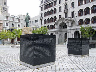
Church Square in Cape Town, South Africa, lies in front of the Groote Kerk at the intersection of Parliament and Spin Streets. It currently features a park.
Louis van Assenburgh, , Governor of the Cape Colony between 1708 and 1711.
Petrus Johannes Kotzé was Mayor of Cape Town and member of the Parliament of the Cape of Good Hope.
Hans Heinrich Hattingh (c.1662-1729), otherwise known as Hans Hendrik Hattingh, was a German settler in the Dutch Cape Colony. He was a free burgher of the Dutch East India Company.
33°56′36″S18°28′32″E / 33.943408°S 18.475474°E