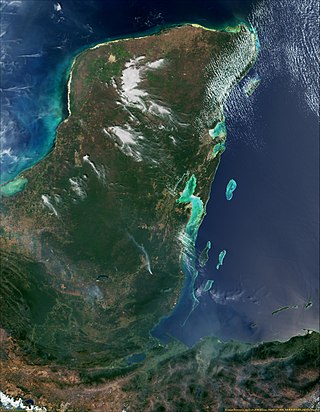
The Coral Sea Islands Territory is an external territory of Australia which comprises a group of small and mostly uninhabited tropical islands and reefs in the Coral Sea, north-east of Queensland, Australia. The only inhabited island is Willis Island. The territory covers 780,000 km2 (301,160 sq mi), most of which is ocean, extending east and south from the outer edge of the Great Barrier Reef and includes Heralds Beacon Island, Osprey Reef, the Willis Group and fifteen other reef/island groups. Cato Island is the highest point in the Territory.

In physical geography, a fjord or fiord is a long, narrow sea inlet with steep sides or cliffs, created by a glacier. Fjords exist on the coasts of Antarctica, the Arctic, and surrounded landmasses of the northern and southern hemispheres. Norway's coastline is estimated to be 29,000 km (18,000 mi) long with its nearly 1,200 fjords, but only 2,500 km (1,600 mi) long excluding the fjords.
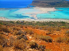
An atoll is a ring-shaped island, including a coral rim that encircles a lagoon. There may be coral islands or cays on the rim. Atolls are located in warm tropical or subtropical parts of the oceans and seas where corals can develop. Most of the approximately 440 atolls in the world are in the Pacific Ocean.

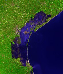
An estuary is a partially enclosed coastal body of brackish water with one or more rivers or streams flowing into it, and with a free connection to the open sea. Estuaries form a transition zone between river environments and maritime environments and are an example of an ecotone. Estuaries are subject both to marine influences such as tides, waves, and the influx of saline water, and to fluvial influences such as flows of freshwater and sediment. The mixing of seawater and freshwater provides high levels of nutrients both in the water column and in sediment, making estuaries among the most productive natural habitats in the world.

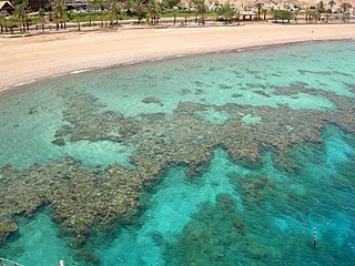
A coral reef is an underwater ecosystem characterized by reef-building corals. Reefs are formed of colonies of coral polyps held together by calcium carbonate. Most coral reefs are built from stony corals, whose polyps cluster in groups.

The Venetian Lagoon is an enclosed bay of the Adriatic Sea, in northern Italy, in which the city of Venice is situated. Its name in the Italian and Venetian languages, Laguna Veneta—cognate of Latin lacus, "lake"—has provided the English name for an enclosed, shallow embayment of salt water, a lagoon.

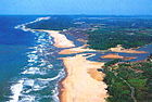
In oceanography, geomorphology, and geoscience, a shoal is a natural submerged ridge, bank, or bar that consists of, or is covered by, sand or other unconsolidated material, and rises from the bed of a body of water close to the surface or above it, which poses a danger to navigation. Shoals are also known as sandbanks, sandbars, or gravelbars. Two or more shoals that are either separated by shared troughs or interconnected by past or present sedimentary and hydrographic processes are referred to as a shoal complex.

Biscayne Bay is a lagoon with characteristics of an estuary located on the Atlantic coast of South Florida. The northern end of the lagoon is surrounded by the densely developed heart of the Miami metropolitan area while the southern end is largely undeveloped with a large portion of the lagoon included in Biscayne National Park.
The Gulf or Bay of Honduras is a large inlet of the Caribbean Sea, indenting the coasts of Belize, Guatemala, and Honduras. From north to south, it runs for approximately 200 km from Dangriga, Belize, to La Ceiba, Honduras.

Laguna de Términos is the largest tidal lagoon by volume located entirely on the Gulf of Mexico, as well as one of the most biodiverse. Exchanging water with several rivers and lagoons, the Laguna is part of the most important hydrographic river basin in Mexico. It is important commercially, as well as ecologically by serving as a refuge for extensive flora and fauna; its mangroves play an important role as a refuge for migratory birds.
Lagoa dos Patos is the largest lagoon in Brazil and the largest coastal lagoon in South America. It is located in the state of Rio Grande do Sul, southern Brazil. It covers an area of 10,100 km2 (3,900 sq mi), is 180 miles (290 km) long and has a maximum width of 44 miles (71 km).

Marine ecosystems are the largest of Earth's aquatic ecosystems and exist in waters that have a high salt content. These systems contrast with freshwater ecosystems, which have a lower salt content. Marine waters cover more than 70% of the surface of the Earth and account for more than 97% of Earth's water supply and 90% of habitable space on Earth. Seawater has an average salinity of 35 parts per thousand of water. Actual salinity varies among different marine ecosystems. Marine ecosystems can be divided into many zones depending upon water depth and shoreline features. The oceanic zone is the vast open part of the ocean where animals such as whales, sharks, and tuna live. The benthic zone consists of substrates below water where many invertebrates live. The intertidal zone is the area between high and low tides. Other near-shore (neritic) zones can include mudflats, seagrass meadows, mangroves, rocky intertidal systems, salt marshes, coral reefs, lagoons. In the deep water, hydrothermal vents may occur where chemosynthetic sulfur bacteria form the base of the food web.
The São Gonçalo Channel is a navigable channel connecting two large coastal lagoons, Lagoa Mirim and Lagoa dos Patos, in the state of Rio Grande do Sul in southern Brazil. At its eastern end, it separates the municipalities of Rio Grande to the south from Pelotas to the north.

Cocos Lagoon appears as a small incomplete coral atoll attached to the south-western coast of Guam near the area of the village of Malesso'. It stretches about 5.5 km (3.4 mi) east-west and 3.5 km (2.2 mi) north-south, covering an area of more than 10 km2 (3.9 sq mi).

The Fitzgerald River is a river in the Great Southern region of Western Australia.
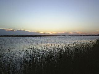
Washdyke Lagoon is a brackish shallow coastal lagoon approximately 1 kilometre (0.62 mi) north of Timaru, South Canterbury, New Zealand. The lagoon has drastically reduced in size since 1881 when it was approximately 253 hectares, now it is less than 48 hectares (0.48 km2) in area. It is enclosed by a barrier beach that is 3 kilometres (1.9 mi) long and 3 metres (9.8 ft) above high tide at its largest point. The reduced lagoon size is due to the construction of the Timaru Port breakwater which is preventing coarse sediments from reaching and replenishing Washdyke Barrier. This is important as the lagoon and the surrounding 250 hectares are classified as a wildlife refuge and it demonstrates the role human structures have on coastline evolution.
A fringing reef is one of the three main types of coral reef. It is distinguished from the other main types, barrier reefs and atolls, in that it has either an entirely shallow backreef zone (lagoon) or none at all. If a fringing reef grows directly from the shoreline, then the reef flat extends to the beach and there is no backreef. In other cases, fringing reefs may grow hundreds of yards from shore and contain extensive backreef areas within which it contains food and water. Some examples of this are Philippines, Indonesia, Timor-Leste, the western coast of Australia, the Caribbean, East Africa, and Red Sea. Charles Darwin believed that fringing reefs are the first kind of reefs to form around a landmass in a long-term reef growth process. The largest fringing coral reef in the world is the Ningaloo Reef, stretching to around 260 km (160 mi) along the coastline of Western Australia.
Estuaries of Australia are features of the Australian coastline. They are linked to tides, river mouths and coastal features and conditions. In many cases the features of estuaries are also named inlets.

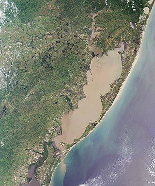
The U.S. state of Texas has a series of estuaries along its coast on the Gulf of Mexico, most of them bounded by the Texas barrier islands. Estuaries are coastal bodies of water in which freshwater from rivers mixes with saltwater from the sea. Twenty-one drainage basins terminate along the Texas coastline, forming a chain of seven major and five minor estuaries: listed from southwest to northeast, these are the Rio Grande Estuary, Laguna Madre, the Nueces Estuary, the Mission–Aransas Estuary, the Guadalupe Estuary, the Colorado–Lavaca Estuary, East Matagorda Bay, the San Bernard River and Cedar Lakes Estuary, the Brazos River Estuary, Christmas Bay, the Trinity–San Jacinto Estuary, and the Sabine–Neches Estuary. Each estuary is named for its one or two chief contributing rivers, excepting Laguna Madre, East Matagorda Bay, and Christmas Bay, which have no major river sources. The estuaries are also sometimes referred to by the names of their respective primary or central water bodies, though each also includes smaller secondary bays, inlets, or other marginal water bodies.

The Coral reefs of the Solomon Islands consists of six major islands and over 986 smaller islands, in Oceania, to the east of Papua New Guinea and northwest of Vanuatu. The Solomon Islands lie between latitudes 5° and 13°S, and longitudes 155° and 169°E. The distance between the westernmost and easternmost islands is about 1,500 km (930 mi). The Santa Cruz Islands are situated north of Vanuatu and are especially isolated at more than 200 km (120 mi) from the other islands. The Solomon Islands has the 22nd largest Exclusive Economic Zone of 1,589,477 km2 (613,701 sq mi) of the Pacific Ocean.
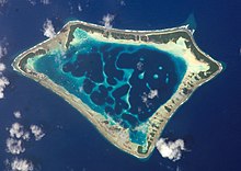

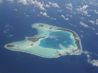
 Aerial view of Bora Bora in French Polynesia.
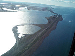 Aerial view of Kivalina, Alaska from the northwest.
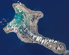 Nearly half the area of Kiritimati is covered with lagoons, some freshwater and some seawater.
 Panoramic view of Lefkada City Lagoon, Lefkada Isl., Ionian Islands Prefecture, Greece.
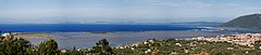
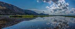 Panoramic view of Prokopos Lagoon, Achaia, Western Greece Prefecture, Greece.
 Tropical lagoon in Bacuit Bay, Palawan, Philippines.
 Photo of Mar Menor as seen from International Space Station.