Subsidence

Last updated
Subsided house, called The Crooked House, the result of 19th-century mining subsidence in Staffordshire, England The Crooked House.jpg
Subsided house, called The Crooked House, the result of 19th-century mining subsidence in Staffordshire, England
Mam Tor road destroyed by subsidence and shear, near Castleton, Derbyshire SubsidedRoad.jpg
Mam Tor road destroyed by subsidence and shear, near Castleton, Derbyshire

Subsidence is a general term for downward vertical movement of the Earth's surface, which can be caused by both natural processes and human activities. Subsidence involves little or no horizontal movement, [1] [2] which distinguishes it from slope movement. [3]

Contents

Processes that lead to subsidence include dissolution of underlying carbonate rock by groundwater; gradual compaction of sediments; withdrawal of fluid lava from beneath a solidified crust of rock; mining; pumping of subsurface fluids, such as groundwater or petroleum; or warping of the Earth's crust by tectonic forces. Subsidence resulting from tectonic deformation of the crust is known as tectonic subsidence [1] and can create accommodation for sediments to accumulate and eventually lithify into sedimentary rock. [2]

Ground subsidence is of global concern to geologists, geotechnical engineers, surveyors, engineers, urban planners, landowners, and the public in general. [4] Pumping of groundwater or petroleum has led to subsidence of as much as 9 meters (30 ft) in many locations around the world and incurring costs measured in hundreds of millions of US dollars. [5]

Causes

Dissolution of limestone

Subsidence frequently causes major problems in karst terrains, where dissolution of limestone by fluid flow in the subsurface creates voids (i.e., caves). If the roof of a void becomes too weak, it can collapse and the overlying rock and earth will fall into the space, causing subsidence at the surface. This type of subsidence can cause sinkholes which can be many hundreds of meters deep. [6]

Mining

Several types of sub-surface mining, and specifically methods which intentionally cause the extracted void to collapse (such as pillar extraction, longwall mining and any metalliferous mining method which uses "caving" such as "block caving" or "sub-level caving") will result in surface subsidence. Mining-induced subsidence is relatively predictable in its magnitude, manifestation and extent, except where a sudden pillar or near-surface tunnel collapse occurs (usually very old workings [7] ). Mining-induced subsidence is nearly always very localized to the surface above the mined area, plus a margin around the outside. [8] The vertical magnitude of the subsidence itself typically does not cause problems, except in the case of drainage (including natural drainage)–rather, it is the associated surface compressive and tensile strains, curvature, tilts and horizontal displacement that are the cause of the worst damage to the natural environment, buildings and infrastructure. [9]

Where mining activity is planned, mining-induced subsidence can be successfully managed if there is co-operation from all of the stakeholders. This is accomplished through a combination of careful mine planning, the taking of preventive measures, and the carrying out of repairs post-mining. [10]

Stabilizing damaged homes above underground mine in Bradenville PA USA Abandoned coal mine subsidence stablization project.jpg
Stabilizing damaged homes above underground mine in Bradenville PA USA
Types of ground subsidence Wiki Image Rev1.svg
Types of ground subsidence

Extraction of petroleum and natural gas

If natural gas is extracted from a natural gas field the initial pressure (up to 60 MPa (600 bar)) in the field will drop over the years. The pressure helps support the soil layers above the field. If the gas is extracted, the overburden pressure sediment compacts and may lead to earthquakes and subsidence at the ground level.

Since exploitation of the Slochteren (Netherlands) gas field started in the late 1960s the ground level over a 250 km2 area has dropped by a current maximum of 30 cm. [11]

Extraction of petroleum likewise can cause significant subsidence. The city of Long Beach, California, has experienced 9 meters (30 ft) over the course of 34 years of petroleum extraction, resulting in damage of over $100 million to infrastructure in the area. The subsidence was brought to a halt when secondary recovery wells pumped enough water into the oil reservoir to stabilize it. [5]

Earthquake

Land subsidence can occur in various ways during an earthquake. Large areas of land can subside drastically during an earthquake because of offset along fault lines. Land subsidence can also occur as a result of settling and compacting of unconsolidated sediment from the shaking of an earthquake. [12]

The Geospatial Information Authority of Japan reported immediate subsidence caused by the 2011 Tōhoku earthquake. [13] In Northern Japan, subsidence of 0.50 m (1.64 ft) was observed on the coast of the Pacific Ocean in Miyako, Tōhoku, while Rikuzentakata, Iwate measured 0.84 m (2.75 ft). In the south at Sōma, Fukushima, 0.29 m (0.95 ft) was observed. The maximum amount of subsidence was 1.2 m (3.93 ft), coupled with horizontal diastrophism of up to 5.3 m (17.3 ft) on the Oshika Peninsula in Miyagi Prefecture. [14]

San Joaquin Valley subsidence Gwsanjoaquin.jpg
San Joaquin Valley subsidence

Groundwater-related subsidence is the subsidence (or the sinking) of land resulting from groundwater extraction. It is a growing problem in the developing world as cities increase in population and water use, without adequate pumping regulation and enforcement. One estimate has 80% of serious land subsidence problems associated with the excessive extraction of groundwater, [15] making it a growing problem throughout the world.

Groundwater fluctuations can also indirectly affect the decay of organic material. The habitation of lowlands, such as coastal or delta plains, requires drainage. The resulting aeration of the soil leads to the oxidation of its organic components, such as peat, and this decomposition process may cause significant land subsidence. This applies especially when groundwater levels are periodically adapted to subsidence, in order to maintain desired unsaturated zone depths, exposing more and more peat to oxygen. In addition to this, drained soils consolidate as a result of increased effective stress. [16] [17] In this way, land subsidence has the potential of becoming self-perpetuating, having rates up to 5 cm/yr. Water management used to be tuned primarily to factors such as crop optimization but, to varying extents, avoiding subsidence has come to be taken into account as well.

Faulting induced

When differential stresses exist in the Earth, these can be accommodated either by geological faulting in the brittle crust, or by ductile flow in the hotter and more fluid mantle. Where faults occur, absolute subsidence may occur in the hanging wall of normal faults. In reverse, or thrust, faults, relative subsidence may be measured in the footwall. [18]

Isostatic subsidence

The crust floats buoyantly in the asthenosphere, with a ratio of mass below the "surface" in proportion to its own density and the density of the asthenosphere. If mass is added to a local area of the crust (e.g., through deposition), the crust subsides to compensate and maintain isostatic balance. [2]

The opposite of isostatic subsidence is known as isostatic rebound—the action of the crust returning (sometimes over periods of thousands of years) to a state of isostacy, such as after the melting of large ice sheets or the drying-up of large lakes after the last ice age. Lake Bonneville is a famous example of isostatic rebound. Due to the weight of the water once held in the lake, the earth's crust subsided nearly 200 feet (61 m) to maintain equilibrium. When the lake dried up, the crust rebounded. Today at Lake Bonneville, the center of the former lake is about 200 feet (61 m) higher than the former lake edges. [19]

Seasonal effects

Many soils contain significant proportions of clay. Because of the very small particle size, they are affected by changes in soil moisture content. Seasonal drying of the soil results in a lowering of both the volume and the surface of the soil. If building foundations are above the level reached by seasonal drying, they move, possibly resulting in damage to the building in the form of tapering cracks.

Trees and other vegetation can have a significant local effect on seasonal drying of soils. Over a number of years, a cumulative drying occurs as the tree grows. That can lead to the opposite of subsidence, known as heave or swelling of the soil, when the tree declines or is felled. As the cumulative moisture deficit is reversed, which can last up to 25 years, the surface level around the tree will rise and expand laterally. That often damages buildings unless the foundations have been strengthened or designed to cope with the effect. [20]

Impacts

Sinking cities

Drivers, processes, and impacts of sinking cities Drivers, Processes, and Impacts of Sinking Cities.png
Drivers, processes, and impacts of sinking cities
Sinking cities are urban environments that are in danger of disappearing due to their rapidly changing landscapes. The largest contributors to these cities becoming unlivable are the combined effects of climate change (manifested through sea level rise, intensifying storms, and storm surge), land subsidence, and accelerated urbanization. [22] Many of the world's largest and most rapidly growing cities are located along rivers and coasts, exposing them to natural disasters. As countries continue to invest people, assets, and infrastructure into these cities, the loss potential in these areas also increases. [23] Sinking cities must overcome substantial barriers to properly prepare for today's dynamic environmental climate.

See also

Related Research Articles

<span class="mw-page-title-main">Earthquake</span> Sudden movement of the Earths crust

An earthquake – also called a quake, tremor, or temblor – is the shaking of the surface of Earth resulting from a sudden release of energy in the lithosphere that creates seismic waves. Earthquakes can range in intensity, from those that are so weak that they cannot be felt, to those violent enough to propel objects and people into the air, damage critical infrastructure, and wreak destruction across entire cities. The seismic activity of an area is the frequency, type, and size of earthquakes experienced over a particular time. The seismicity at a particular location in the Earth is the average rate of seismic energy release per unit volume. The word tremor is also used for non-earthquake seismic rumbling.

<span class="mw-page-title-main">Environmental geology</span> Science of the practical application of geology in environmental problems.

Environmental geology, like hydrogeology, is an applied science concerned with the practical application of the principles of geology in the solving of environmental problems created by man. It is a multidisciplinary field that is closely related to engineering geology and, to a lesser extent, to environmental geography. Each of these fields involves the study of the interaction of humans with the geologic environment, including the biosphere, the lithosphere, the hydrosphere, and to some extent the atmosphere. In other words, environmental geology is the application of geological information to solve conflicts, minimizing possible adverse environmental degradation, or maximizing possible advantageous conditions resulting from the use of natural and modified environment. With an increasing world population and industrialization, the natural environment and resources are under high strain which puts them at the forefront of world issues. Environmental geology is on the rise with these issues as solutions are found by utilizing it.

<span class="mw-page-title-main">Fault (geology)</span> Fracture or discontinuity in rock across which there has been displacement

In geology, a fault is a planar fracture or discontinuity in a volume of rock across which there has been significant displacement as a result of rock-mass movements. Large faults within Earth's crust result from the action of plate tectonic forces, with the largest forming the boundaries between the plates, such as the megathrust faults of subduction zones or transform faults. Energy release associated with rapid movement on active faults is the cause of most earthquakes. Faults may also displace slowly, by aseismic creep.

Isostasy or isostatic equilibrium is the state of gravitational equilibrium between Earth's crust and mantle such that the crust "floats" at an elevation that depends on its thickness and density. This concept is invoked to explain how different topographic heights can exist at Earth's surface. Although originally defined in terms of continental crust and mantle, it has subsequently been interpreted in terms of lithosphere and asthenosphere, particularly with respect to oceanic island volcanoes, such as the Hawaiian Islands.

<span class="mw-page-title-main">Lake Bonneville</span> Former pluvial lake in western North America

Lake Bonneville was the largest Late Pleistocene paleolake in the Great Basin of western North America. It was a pluvial lake that formed in response to an increase in precipitation and a decrease in evaporation as a result of cooler temperatures. The lake covered much of what is now western Utah and at its highest level extended into present-day Idaho and Nevada. Many other hydrographically closed basins in the Great Basin contained expanded lakes during the Late Pleistocene, including Lake Lahontan in northwestern Nevada.

<span class="mw-page-title-main">Water extraction</span> Process of taking water from any source

Water extraction is the process of taking water from any source, either temporarily or permanently, for flood control or to obtain water for, for example, irrigation. The extracted water could also be used as drinking water after suitable treatment.

<span class="mw-page-title-main">Groundwater</span> Water located beneath the ground surface

Groundwater is the water present beneath Earth's surface in rock and soil pore spaces and in the fractures of rock formations. About 30 percent of all readily available freshwater in the world is groundwater. A unit of rock or an unconsolidated deposit is called an aquifer when it can yield a usable quantity of water. The depth at which soil pore spaces or fractures and voids in rock become completely saturated with water is called the water table. Groundwater is recharged from the surface; it may discharge from the surface naturally at springs and seeps, and can form oases or wetlands. Groundwater is also often withdrawn for agricultural, municipal, and industrial use by constructing and operating extraction wells. The study of the distribution and movement of groundwater is hydrogeology, also called groundwater hydrology.

<span class="mw-page-title-main">California Aqueduct</span> Water supply project

The Governor Edmund G. Brown California Aqueduct is a system of canals, tunnels, and pipelines that conveys water collected from the Sierra Nevada Mountains and valleys of Northern and Central California to Southern California. Named after California Governor Edmund Gerald "Pat" Brown Sr., the over 400-mile (640 km) aqueduct is the principal feature of the California State Water Project.

<span class="mw-page-title-main">Post-glacial rebound</span> Rise of land masses after glacial period

Post-glacial rebound is the rise of land masses after the removal of the huge weight of ice sheets during the last glacial period, which had caused isostatic depression. Post-glacial rebound and isostatic depression are phases of glacial isostasy, the deformation of the Earth's crust in response to changes in ice mass distribution. The direct raising effects of post-glacial rebound are readily apparent in parts of Northern Eurasia, Northern America, Patagonia, and Antarctica. However, through the processes of ocean siphoning and continental levering, the effects of post-glacial rebound on sea level are felt globally far from the locations of current and former ice sheets.

<span class="mw-page-title-main">Diastrophism</span> Deformation of the Earths crust

Diastrophism is the process of deformation of the Earth's crust which involves folding and faulting. Diastrophism can be considered part of geotectonics. The word is derived from the Greek διαστροϕή diastrophḗ 'distortion, dislocation'.

In tectonics, vertical displacement refers to the shifting of land in a vertical direction, resulting in uplift and subsidence. The displacement of rock layers can provide information on how and why Earth's lithosphere changes throughout geologic time. There are different mechanisms which lead to vertical displacement such as tectonic activity, and isostatic adjustments. Tectonic activity leads to vertical displacement when crust is rearranged during a seismic event. Isostatic adjustments result in vertical displacement through sinking due to an increased load or isostatic rebound due to load removal.

Tectonic uplift is the geologic uplift of Earth's surface that is attributed to plate tectonics. While isostatic response is important, an increase in the mean elevation of a region can only occur in response to tectonic processes of crustal thickening, changes in the density distribution of the crust and underlying mantle, and flexural support due to the bending of rigid lithosphere.

<span class="mw-page-title-main">Knickpoint</span> Point on a streams profile where a sudden change in stream gradient occurs

In geomorphology, a knickpoint or nickpoint is part of a river or channel where there is a sharp change in channel bed slope, such as a waterfall or lake. Knickpoints reflect different conditions and processes on the river, often caused by previous erosion due to glaciation or variance in lithology. In the cycle of erosion model, knickpoints advance one cycle upstream, or inland, replacing an older cycle. A knickpoint that occurs at the head of a channel is called a headcut. Headcuts resulting in headward erosion are hallmarks of unstable expanding drainage features such as actively eroding gullies.

<span class="mw-page-title-main">Geography of Houston</span> Geogrsphic aspects of Texas most populous city

Houston, the most populous city in the Southern United States, is located along the upper Texas Gulf Coast, approximately 50 miles (80 km) northwest of the Gulf of Mexico at Galveston. The city, which is the ninth-largest in the United States by area, covers 601.7 square miles (1,558 km2), of which 579.4 square miles (1,501 km2), or 96.3%, is land and 22.3 square miles (58 km2), or 3.7%, is water.

<span class="mw-page-title-main">Interferometric synthetic-aperture radar</span> Geodesy and remote sensing technique

Interferometric synthetic aperture radar, abbreviated InSAR, is a radar technique used in geodesy and remote sensing. This geodetic method uses two or more synthetic aperture radar (SAR) images to generate maps of surface deformation or digital elevation, using differences in the phase of the waves returning to the satellite or aircraft. The technique can potentially measure millimetre-scale changes in deformation over spans of days to years. It has applications for geophysical monitoring of natural hazards, for example earthquakes, volcanoes and landslides, and in structural engineering, in particular monitoring of subsidence and structural stability.

<span class="mw-page-title-main">Overdrafting</span> Unsustainable extraction of groundwater

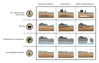
Overdrafting is the process of extracting groundwater beyond the equilibrium yield of an aquifer. Groundwater is one of the largest sources of fresh water and is found underground. The primary cause of groundwater depletion is the excessive pumping of groundwater up from underground aquifers.

Groundwater-related subsidence is the subsidence of land resulting from unsustainable groundwater extraction. It is a growing problem in the developing world as cities increase in population and water use, without adequate pumping regulation and enforcement. One estimate has 80% of serious U.S. land subsidence problems associated with the excessive extraction of groundwater.

The 1964 Niigata earthquake struck at 13:01 local time on 16 June with a magnitude of either 7.5 or 7.6. The epicenter was on the continental shelf off the northwest coast of Honshu, Japan, in Niigata Prefecture, about 50 kilometres (31 mi) north of the city of Niigata. The earthquake caused liquefaction over large parts of the city.

Tectonic subsidence is the sinking of the Earth's crust on a large scale, relative to crustal-scale features or the geoid. The movement of crustal plates and accommodation spaces produced by faulting brought about subsidence on a large scale in a variety of environments, including passive margins, aulacogens, fore-arc basins, foreland basins, intercontinental basins and pull-apart basins. Three mechanisms are common in the tectonic environments in which subsidence occurs: extension, cooling and loading.

<span class="mw-page-title-main">Fissure</span> Long, narrow crack opening on a planetary surface

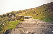
A fissure is a long, narrow crack opening along the surface of Earth. The term is derived from the Latin word fissura, which means 'cleft' or 'crack'. Fissures emerge in Earth's crust, on ice sheets and glaciers, and on volcanoes.

References

  1. 1 2 Jackson, Julia A., ed. (1997). "subsidence". Glossary of geology (Fourth ed.). Alexandria, Virginia: American Geological Institute. ISBN   0922152349.
  2. 1 2 3 Allaby, Michael (2013). "subsidence". A dictionary of geology and earth sciences (Fourth ed.). Oxford: Oxford University Press. ISBN   9780199653065.
  3. Fleming, Robert W.; Varnes, David J. (1991). "Slope movements". The Heritage of Engineering Geology; the First Hundred Years: 201–218. doi:10.1130/DNAG-CENT-v3.201. ISBN   0813753031.
  4. National Research Council, 1991. Mitigating losses from land subsidence in the United States. National Academies Press. 58 p.
  5. 1 2 Monroe, James S. (1992). Physical geology : exploring the Earth. St. Paul: West Pub. Co. pp. 502–503. ISBN   0314921958.
  6. Waltham, T.; Bell, F.G.; Culshaw, M.G. (2005). Sinkholes and Subsidence. Karst and Cavernous Rocks in Engineering and Const. doi:10.1007/b138363. ISBN   978-3-540-20725-2.
  7. Herrera, G.; Tomás, R.; López-Sánchez, J.M.; Delgado, J.; Mallorquí, J.; Duque, S.; Mulas, J. Advanced DInSAR analysis on mining areas: La Union case study (Murcia, SE Spain). Engineering Geology, 90, 148-159, 2007.
  8. "Graduated Guidelines for Residential Construction (New South Wales) Volume 1" (PDF). Retrieved 2012-11-19.
  9. G. Herrera, M.I. Álvarez Fernández, R. Tomás, C. González-Nicieza, J. M. Lopez-Sanchez, A.E. Álvarez Vigil. Forensic analysis of buildings affected by mining subsidence based on Differential Interferometry (Part III). Engineering Failure Analysis 24, 67-76, 2012.
  10. Bauer, R.A. (2008). "Planned coal mine subsidence in Illinois: a public information booklet" (PDF). Illinois State Geological Survey Circular. 573. Retrieved 10 December 2021.
  11. Subsidence lecture Archived 2004-10-30 at the Wayback Machine
  12. "Earthquake Induced Land Subsidence" . Retrieved 2018-06-25.
  13. 平成23年(2011年)東北地方太平洋沖地震に伴う地盤沈下調査 [Land subsidence caused by 2011 Tōhoku earthquake and tsunami] (in Japanese). Geospatial Information Authority of Japan. 2011-04-14. Retrieved 2011-04-17.
  14. Report date on 19 March 2011, Diastrophism in Oshika Peninsula on 2011 Tōhoku earthquake and tsunami, Diastrophism in vertical 2011-03-11 M9.0, Diastrophism in horizontal 2011-03-11 M9.0 Geospatial Information Authority of Japan
  15. USGS Fact Sheet-165-00 December 2000
  16. Tomás, R.; Márquez, Y.; Lopez-Sanchez, J.M.; Delgado, J.; Blanco, P.; Mallorquí, J.J.; Martínez, M.; Herrera, M.; Mulas, J. Mapping ground subsidence induced by aquifer overexploitation using advanced Differential SAR interferometry: Vega Media of the Segura river (SE Spain) case study. Remote Sensing of Environment, 98, 269-283, 2005
  17. R. Tomás, G. Herrera, J.M. Lopez-Sanchez, F. Vicente, A. Cuenca, J.J. Mallorquí. Study of the land subsidence in the Orihuela city (SE Spain) using PSI data: distribution, evolution, and correlation with conditioning and triggering factors. Engineering Geology, 115, 105-121, 2010.
  18. Lee, E.Y., Novotny, J., Wagreich, M. (2019) Subsidence analysis and visualization: for sedimentary basin analysis and modelling, Springer. doi : 10.1007/978-3-319-76424-5
  19. Adams, K.D.; Bills, B.G. (2016). "Isostatic Rebound and Palinspastic Restoration of the Bonneville and Provo Shorelines in the Bonneville Basin, UT, NV, and ID". Developments in Earth Surface Processes. 20: 145–164. doi:10.1016/B978-0-444-63590-7.00008-1. ISBN   9780444635907.
  20. Page, R.C.J. (June 1998). "Reducing the cost of subsidence damage despite global warming". Structural Survey. 16 (2): 67–75. doi:10.1108/02630809810219641.
  21. Erkens, G.; Bucx, T.; Dam, R.; de Lange, G.; Lambert, J. (2015-11-12). "Sinking coastal cities". Proceedings of the International Association of Hydrological Sciences. Copernicus GmbH. 372: 189–198. Bibcode:2015PIAHS.372..189E. doi: 10.5194/piahs-372-189-2015 .
  22. Fuchs, Roland (July 2010). "Cities at Risk: Asia's Coastal Cities in an Age of Climate Change". Asia Pacific Issues. 96: 1–12.
  23. Sundermann, L., Schelske, O., & Hausmann, P. (2014). Mind the risk – A global ranking of cities under threat from natural disasters. Swiss Re.