
Limpopo is the northernmost province of South Africa. It is named after the Limpopo River, which forms the province's western and northern borders. The capital and largest city in the province is Polokwane, while the provincial legislature is situated in Lebowakgomo.

Paarl is a town with 112,045 inhabitants in the Western Cape province of South Africa. It is the third-oldest city and European settlement in the Republic of South Africa and the largest town in the Cape Winelands. Due to the growth of the Mbekweni township, it is now a de facto urban unit with Wellington. It is situated about 60 kilometres (37 mi) northeast of Cape Town in the Western Cape Province and is known for its scenic environment and viticulture and fruit-growing heritage.
Stellenbosch is a town in the Western Cape province of South Africa, situated about 50 kilometres east of Cape Town, along the banks of the Eerste River at the foot of the Stellenbosch Mountain. The town became known as the City of Oaks or Eikestad in Afrikaans and Dutch due to the large number of oak trees that were planted by its founder, Simon van der Stel, to grace the streets and homesteads.
Kokstad is a town in the Harry Gwala District Municipality of KwaZulu-Natal Province, South Africa. Kokstad is named after the Griqua chief Adam Kok III who settled here in 1863. Kokstad is the capital town of the East Griqualand region, as it is also the biggest town in this region. It was built around Mount Currie, a local mountain range, by the city's founder Adam Kok III, for whom the town is named. Stad is the Dutch and Afrikaans word for "city".

Uitenhage, officially renamed Kariega, is a South African town in the Eastern Cape Province. It is well known for the Volkswagen factory located there, which is the biggest car factory on the African continent. Along with the city of Port Elizabeth and the small town of Despatch, it forms the Nelson Mandela Metropolitan Municipality.

Ermelo is the educational, industrial and commercial town of the 7,750 km2 Gert Sibande District Municipality in Mpumalanga province, Republic of South Africa. It is both a mixed agriculture and mining region. It is located 210 km east of Johannesburg.

Qonce, also known as King William's Town, is a town in the Eastern Cape province of South Africa along the banks of the Buffalo River. The city is about 60 kilometres (37 mi) northwest of the Indian Ocean port of East London. Qonce, with a population of around 35,000 inhabitants, forms part of the Buffalo City Metropolitan Municipality.

Kraaifontein is a town in the Western Cape province of South Africa. Organisationally and administratively it is included in the City of Cape Town Metropolitan Municipality as a Northern Suburb. The name originated from large number of crows that nest in the region.
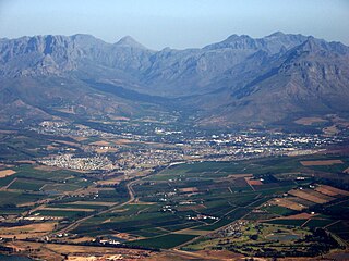
Ceres is the administrative centre and largest town of the Witzenberg Local Municipality in the Western Cape Province of South Africa. Ceres serves as a regional centre for the surrounding towns of Wolseley, Tulbagh, Op-die-Berg and Prince Alfred Hamlet. It is situated in the Warmbokkeveld Valley about 170 km north-east of Cape Town. Ceres is located at the north-eastern entrance to Michell's Pass and was the old route north between Cape Town and Johannesburg, which was later replaced by the N1 highway, which traverses the Breede River Valley to the south.

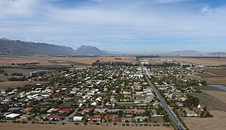
Middelburg is a town in the Eastern Cape province of South Africa, in the Great Karoo. It lies in the Upper Karoo, 1,279 m above sea level, with a population of 19,000. It falls under the Inxuba Yethemba Local Municipality, in the Chris Hani District Municipality.
The Langkloof is a 160 km long valley in South Africa, lying between Herold, a small village northeast of George, and The Heights - just beyond Twee Riviere.

The Kouga Dam is an arch dam on the Kouga River about 21 km (13 mi) west of Patensie in Kouga Local Municipality, South Africa. It supplies irrigation water to the Kouga and Gamtoos valleys as well as drinking water to the Port Elizabeth metropolitan area via the Loerie Balancing Dam. It was constructed between 1957 and 1969.
Porterville is a town in the Western Cape province of South Africa.

The Kouga Local Municipality is located in the Eastern Cape of South Africa, approximately 80 km west of Port Elizabeth, and forms part of the Sarah Baartman District Municipality. Its territory includes the coastal zone between the Van Stadens River in the east and the Tsitsikamma River in the west, and stretches inland towards the Baviaanskloof Mountains in the north.

Kareedouw or Kareedowns is a town in the Eastern Cape province of South Africa. It is the administrative centre for the Kou-Kamma Municipality in the Sarah Baartman District of the Eastern Cape.

Saint Helena Bay is a settlement in West Coast District Municipality in the Western Cape province of South Africa.
Elliot, officially known as Khowa, is a town in Chris Hani District Municipality in the Eastern Cape province of South Africa, and lies 80 km south-west of Maclear and 65 km south-east of Barkly East on the R56 road.

Patensie is a town in Sarah Baartman District Municipality in the Eastern Cape province of South Africa. Patensie lies along the R331 road just south of Noorshoek. The Kouga Dam is located several kilometres to the west. The name is Khoi in origin, and means "cattle resting place". The town is a centre for the citrus, tobacco, and vegetable farms in the area.
Jaco Nepgen is a former South African rugby union footballer that played as either lock or flank. He represented Griquas in the Currie Cup and Vodacom Cup competitions between 2010 and 2016, played a single match for the SWD Eagles in the Currie Cup and won back-to-back titles with Maties in the Varsity Cup in 2008 and 2009. He also represented South Africa Universities in 2008 and 2009. In 2009 Nepgen was named Rugby Player of the year for Maties

Paul Oliver Sauer was a South African Cabinet Minister and lifelong member of the National Party.


