N6 (South Africa)

Last updated

SA road N6.svg
National route N6
Map of the N6 (South Africa) with labels.svg
Map of the N6 route
General Hertzog Bridge over Orange River at Aliwal North.jpg
The N6 crosses the Orange River on the Generaal Hertzog Bridge at Maletswai
Route information
Maintained by SANRAL
Length538 km (334 mi)
Major junctions
South endSA road N2 jct.svg N2 in East London
North endSA road N1 jct.svg N1 near Bloemfontein
Location
Country South Africa
Provinces Eastern Cape, Free State
Major cities
Highway system
SA road N5.svg N5 SA road N7.svg N7

The N6 is a national route in South Africa that connects East London with Bloemfontein, via Komani and Maletswai. [1] It runs roughly from north to south, connecting the N1 with the N2.

Contents

Route

Eastern Cape

The N6 begins in the city of East London in the Buffalo City Metropolitan Municipality of the Eastern Cape Province, next to the Nahoon River, at an interchange with the N2 highway. South of the highway, it is the R72 road towards the East London CBD. [1]

It begins by going northwest from the N2 interchange for 31 kilometres to the town of Macleantown, where it leaves the Buffalo City Metropolitan Municipality. It continues northwest for another 21 kilometres to meet the R63 road at an intersection just north-east of Kei Road. [1]

It continues northwest for 19 kilometers to the town of Stutterheim. It proceeds northwest for another 47 kilometers to the town of Cathcart. It proceeds north-north-west for 54 kilometres, crossing the Black Kei River, to reach Queenstown (town renamed Komani in February 2016). [1]

14 kilometers before Komani, the R61 meets the N6 and they are one road into the town of Komani as Louis Botha Road and Cathcart Street. In the Stuttaford suburb of Komani, the R61 becomes its own road westwards at the roundabout junction with Barrable Street.

The N6 continues northwards for 162 kilometres as the Penhoek Pass, bypassing Sterkstroom, meeting the R56 and passing through Jamestown, to the town of Aliwal North (renamed Maletswai in 2016 [2] ), where it meets the R58. At the junction with Barkly Street in Maletswai, the N6 makes a left turn and proceeds to cross the Orange River into the Free State as the General Hertzog Bridge. [1]

Free State

From the Orange River crossing at Maletswai, the N6 goes north-north-east for 34 kilometres to the town of Rouxville, where it meets the southern terminus of the R26. It turns to the north-west and continues for 37 kilometres, crossing the Caledon River, to the town of Smithfield, where the R701 joins it in the southern suburbs before they split in the northern suburbs. [1]

From Smithfield, the N6 continues north-north-west for 70 kilometres to the town of Reddersburg, where it is joined by the R717 from Edenburg in the southern suburbs before they split in the central area. From Reddersburg, the N6 makes a direct line for Bloemfontein, going northwards for 49 kilometres to reach a four-way junction south-west of the Bloemfontein suburb of Mangaung (which is also the name of the Metropolitan Municipality in which the city is located). As the road northwards from this junction is the M30 metropolitan route towards the Mangaung suburb and Bloemfontein Central, the N6 becomes the road westwards and proceeds to end at the next junction, which is an interchange with the N1 highway (Bloemfontein Western Bypass). [1]

History

Prior to 1970, the N6 began from King William's Town in the Buffalo City Metropolitan Municipality and proceeded through Stutterheim. [3] Today, the road from King William's Town to Stutterheim is designated as the R346 road. [1] Also, the N6 used to end at its current junction with the R717 south of the Reddersburg Town Centre, as the R717 from Edenburg to Reddersburg, together with the N6 from Reddersburg to Bloemfontein, formed part of the N1 national route. [3]

Related Research Articles

<span class="mw-page-title-main">National routes (South Africa)</span> National Roads in South Africa

National routes in South Africa are a class of trunk roads and freeways which connect major cities. They form the highest category in the South African route numbering scheme, and are designated with route numbers beginning with "N", from N1 to N18. Most segments of the national route network are officially proclaimed National Roads that are maintained by the South African National Roads Agency (SANRAL), but some segments are maintained by provincial or local road authorities.

<span class="mw-page-title-main">N1 (South Africa)</span> National road in South Africa

The N1 is a national route in South Africa that runs from Cape Town through Bloemfontein, Johannesburg, Pretoria and Polokwane to Beit Bridge on the border with Zimbabwe. It forms the first section of the famed Cape to Cairo Road.

<span class="mw-page-title-main">R30 (South Africa)</span> Road in South Africa

The R30 is a provincial route in South Africa that connects Bloemfontein with Rustenburg via Brandfort, Welkom, Bothaville, Klerksdorp and Ventersdorp. The southern part of the route is tolled, as the R30 forms the first section of the ZR Mahabane Toll Route, with the Brandfort Toll Plaza found 10 kilometres north of its Southern junction with the N1 National Route. The tolled portion ends at the junction with the R730.

<span class="mw-page-title-main">R34 (South Africa)</span> Road in South Africa

The R34 is a long provincial route in South Africa that connects Vryburg with Richards Bay via Kroonstad and Newcastle. It passes through three provinces, North West, the Free State and KwaZulu-Natal.

<span class="mw-page-title-main">R56 (South Africa)</span> Road in South Africa

The R56 is a provincial route in South Africa that connects Middelburg with Pietermaritzburg via Molteno, Maclear and Kokstad. It is co-signed with the N2 between Kokstad and Stafford's Post for 39 kilometres.

<span class="mw-page-title-main">R58 (South Africa)</span>

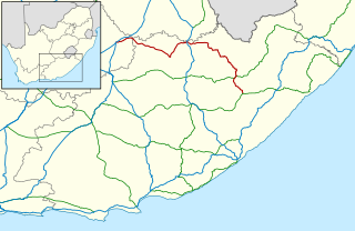
The R58 is a provincial route in South Africa that connects Colesberg with Ngcobo via Aliwal North, Barkly East and Khowa.

<span class="mw-page-title-main">R59 (South Africa)</span> Road in South Africa

The R59 is a provincial route in South Africa that connects Hertzogville with Alberton via Bothaville, Parys and Vereeniging. The R59 is a freeway from the R57 Junction in Sasolburg until the N12 Reading Interchange in Alberton, signposted as the Sybrand van Niekerk Freeway.

<span class="mw-page-title-main">R61 (South Africa)</span> Road in South Africa

The R61 is a long provincial route in South Africa that connects Beaufort West with Port Shepstone via Graaff-Reinet, Komani, Mthatha and Port Edward.

<span class="mw-page-title-main">R63 (South Africa)</span> Road in South Africa

The R63 is a tarred provincial route in South Africa that connects Calvinia with Komga via Carnarvon, Victoria West, Graaff-Reinet, Somerset East and King William's Town. It is cosigned with the N10 between Eastpoort and Cookhouse for 24 kilometres.

<span class="mw-page-title-main">R64 (South Africa)</span>

The R64 is a provincial route in South Africa that connects Kimberley with Bloemfontein via Boshof and Dealesville. It is slightly longer than the newer N8 route via Petrusburg, by about 10 kilometres.

<span class="mw-page-title-main">R67 (South Africa)</span>

The R67 is a provincial route in Eastern Cape, South Africa that connects Port Alfred with Komani via Grahamstown.

<span class="mw-page-title-main">R72 (South Africa)</span>

The R72 is a provincial route in Eastern Cape, South Africa that connects the N2 north-east of Port Elizabeth with East London via Port Alfred. It provides an alternative to the N2 for travel between Port Elizabeth and East London.

<span class="mw-page-title-main">N2 (South Africa)</span> National road in South Africa

The N2 is a national route in South Africa that runs from Cape Town through George, Gqeberha, East London, Mthatha, Port Shepstone and Durban to Ermelo. It is the main highway along the Indian Ocean coast of the country. Its current length of 2,255 kilometres (1,401 mi) makes it the longest numbered route in South Africa.

<span class="mw-page-title-main">N12 (South Africa)</span> National road in South Africa

The N12 is a national route in South Africa which runs from George through Beaufort West, Kimberley, Klerksdorp and Johannesburg to eMalahleni.

<span class="mw-page-title-main">N4 (South Africa)</span> National road in South Africa

The N4 is a national route in South Africa that runs from Skilpadshek on the Botswana border, past Rustenburg, Pretoria, eMalahleni and Mbombela, to Komatipoort on the Mozambique border. The entire route is a toll road.

<span class="mw-page-title-main">Cathcart, South Africa</span> Place in Eastern Cape, South Africa

Cathcart is a town in the Eastern Cape province of South Africa, named after Sir George Cathcart, governor of the Colony of the Cape of Good Hope 1852–1853. The town is situated on the N6, 48 kilometres (30 mi) north of Stutterheim en route to Komani. And it is the Biltong capital of South Africa.

<span class="mw-page-title-main">N8 (South Africa)</span> National road in South Africa

The N8 is a national route in South Africa that connects Groblershoop with Maseru in Lesotho via Kimberley and Bloemfontein. It is maintained by the South African National Roads Agency.

The R702 is a regional route in South Africa that connects Bloemfontein with the Lesotho border at Van Rooyen's Gate via Dewetsdorp and Wepener.

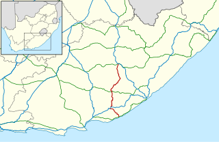
The R717 is a Regional Route in South Africa that connects Colesberg with Dewetsdorp via Trompsburg, Edenburg and Reddersburg. From Colesberg to Reddersburg, it follows the older route of the N1.

The N2 or National Highway 2 is a national highway in Ghana that begins at the Tema Motorway interchange at Tema and runs through Hohoe, Nkwanta, Yendi, and Bawku to the border with Burkina Faso at Kulungugu. It is the main north-south highway in the eastern corridor of the country, with a total distance of 640 kilometres (400 mi). The route runs through the Greater Accra, Eastern, Volta, Oti, Northern, North East Region and Upper East regions of Ghana.

References

  1. 1 2 3 4 5 6 7 8 Falkner, John (May 2012). South African Numbered Route Description and Destination Analysis (Report). National Department of Transport. p. 19. Archived from the original on 6 June 2014. Retrieved 12 August 2014.
  2. "Department of Arts and Culture on its 2015/16 Annual Report | PMG".
  3. 1 2 Anonymous. Shell Road Atlas of Southern Africa. Shell, 1970