Maletswai Local Municipality

Last updated

Maletswai
Maletswai CoA.png
Map of the Eastern Cape with Maletswai highlighted.svg
Location in the Eastern Cape
Coordinates: 30°41′S26°42′E / 30.683°S 26.700°E / -30.683; 26.700
Country South Africa
Province Eastern Cape
District Joe Gqabi
Seat Aliwal North
Wards 6
Government
[1]
  Type Municipal council
  Past MayorN.S. Mathetha
Area
  Total4,358 km2 (1,683 sq mi)
Population
 (2011) [2]
  Total43,800
  Density10/km2 (26/sq mi)
Racial makeup (2011)
[2]
   Black African 85.3%
   Coloured 7.4%
   Indian/Asian 0.2%
   White 6.7%
First languages (2011)
[2]
   Xhosa 62.3%
   Sotho 19.2%
   Afrikaans 14.2%
   English 2.6%
  Other1.7%
Time zone UTC+2 (SAST)
Municipal codeEC143

Maletswai Local Municipality was an administrative area in the Joe Gqabi District of the Eastern Cape in South Africa. The municipality was merged with Gariep Local Municipality immediately after the August 2016 Local Municipal Elections to form the new Walter Sisulu Local Municipality.

Contents

Maletswai is a Sesotho name that means "a place of salt". [3] The thermal springs resort, named Aliwal Spa, is located within the municipal area and produces salty water, rich in minerals, from underground. During 2010-2014 this once beautiful resort was re-constructed and opened to the public again in 2015.

Main places

The 2011 census divided the municipality into the following main places: [4]

PlaceCodeArea (km2)Population
Maletswai 288002 7.9516,001
Dukathole 288001 4.9819,152
Jamestown 288004 11.984,666
Remainder of the municipality 288003 4,306.133,981

Neighbours

The neighbours of Maletswai Local Municipality in the Joe Gqabi District Municipality (DC14) are:

South of Maletswai lies the Chris Hani District Municipality (DC13) with:

On the Free State side is Mohokare Local Municipality in the Xhariep District Municipality (DC16).

Politics

The municipal council consisted of twelve members elected by mixed-member proportional representation. Six councillors were elected by first-past-the-post voting in six wards, while the remaining six were chosen from party lists so that the total number of party representatives is proportional to the number of votes received. In the election of 18 May 2011 the African National Congress (ANC) won a majority of nine seats on the council. The following table shows the results of the election. [5] [6]

PartyVotesSeats
WardListTotal %WardListTotal
ANC 7,9728,30716,27968.2639
Democratic Alliance 1,7121,7963,50814.7022
United Residents Front8121,6022,41410.1011
Independent 1,0331,0334.300
UDM 3422866282.6000
Total11,87111,99123,862100.06612
Spoilt votes443344787

Related Research Articles

<span class="mw-page-title-main">Emnambithi-Ladysmith Local Municipality</span> Local municipality in KwaZulu-Natal, South Africa

Emnambithi-Ladysmith Local Municipality was a municipality in the Uthukela District Municipality, KwaZulu-Natal, South Africa. It is accessible from the N3 and N11 national highways.

<span class="mw-page-title-main">Makhuduthamaga Local Municipality</span> Local municipality in Limpopo, South Africa

Makhuduthamaga Municipality is a local municipality within Sekhukhune District Municipality, in the Limpopo province of South Africa.

<span class="mw-page-title-main">Siyancuma Local Municipality</span> Local municipality in Northern Cape, South Africa

Siyancuma Municipality is a local municipality within the Pixley ka Seme District Municipality, in the Northern Cape province of South Africa.

<span class="mw-page-title-main">Kareeberg Local Municipality</span> Local municipality in Northern Cape, South Africa

Kareeberg Municipality is a local municipality within the Pixley ka Seme District Municipality, in the Northern Cape province of South Africa. The name originates from a mountain range in the region, the Karee Mountains.

<span class="mw-page-title-main">Gariep Local Municipality</span> Former local municipality in Eastern Cape, South Africa

Gariep Local Municipality is a defunct local municipality in Joe Gqabi District Municipality, Eastern Cape. The municipality was merged with Maletswai Local Municipality immediately after the August 2016 Local Municipal Elections to form the new Walter Sisulu Local Municipality.

<span class="mw-page-title-main">Albert Luthuli Local Municipality</span> Local municipality in Mpumalanga, South Africa

Albert Luthuli Municipality is a local municipality within the Gert Sibande District Municipality, in the Mpumalanga province of South Africa. It was named after Albert Luthuli. Carolina is the seat of the municipality.

<span class="mw-page-title-main">Mookgophong Local Municipality</span> Local municipality in Limpopo, South Africa

Mookgophong Local Municipality was a municipality located in the Waterberg District Municipality of Limpopo province, South Africa. The seat of Mookgophong Local Municipality was Mookgophong.

<span class="mw-page-title-main">Mutale Local Municipality</span> Local municipality in Limpopo, South Africa

Mutale Local Municipality was a municipality located in the Vhembe District Municipality of Limpopo province, South Africa. The seat of Mutale Local Municipality was Mutale. It is now part of Thulamela and Musina Local Municipalities.

<span class="mw-page-title-main">Greater Letaba Local Municipality</span> Local municipality in Limpopo, South Africa

Greater Letaba Municipality is a local municipality within the Mopani District Municipality, in the Limpopo province of South Africa. The seat is Modjadjiskloof.

<span class="mw-page-title-main">Ventersdorp Local Municipality</span> Local municipality in North West, South Africa

Ventersdorp Local Municipality was a local municipality in Dr Kenneth Kaunda District Municipality, North West Province, South Africa. The seat of local municipality was Ventersdorp. After the municipal elections on 3 August 2016 it was merged into the larger JB Marks Local Municipality.

<span class="mw-page-title-main">Tlokwe Local Municipality</span> Local municipality in North West, South Africa

Tlokwe Local Municipality was a local municipality in Dr Kenneth Kaunda District Municipality, North West Province, South Africa. The seat was Potchefstroom. After the municipal elections on 3 August 2016 it was merged into the larger JB Marks Local Municipality.

<span class="mw-page-title-main">Nkandla Local Municipality</span> Local municipality in KwaZulu-Natal, South Africa

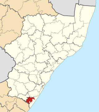
Nkandla Local Municipality is an administrative area in the King Cetshwayo District of KwaZulu-Natal province in South Africa. The town of Nkandla is the home town of the former President of South Africa, Jacob Zuma.

<span class="mw-page-title-main">Joe Morolong Local Municipality</span> Local municipality in Northern Cape, South Africa

Joe Morolong Municipality, formerly Moshaweng Municipality, is a local municipality within the John Taolo Gaetsewe District Municipality, in the Northern Cape province of South Africa.

<span class="mw-page-title-main">Elundini Local Municipality</span> Local municipality in Eastern Cape, South Africa

Elundini Municipality is a local municipality within the Joe Gqabi District Municipality, in the Eastern Cape province of South Africa. The name originates from isiZulu and refers to the Drakensberg Mountains.

<span class="mw-page-title-main">Naledi Local Municipality, Free State</span> Disestablshed local municipality in Free State, South Africa

Naledi Local Municipality was a local municipality in the Free State province in South Africa. On 3 August 2016 it was disestablished and merged into the Mangaung Metropolitan Municipality. The name Naledi is a Sesotho word meaning "a star". The principal towns in the area of the disestablished municipality are Dewetsdorp and Wepener.

<span class="mw-page-title-main">Inkwanca Local Municipality</span> Former local municipality in Eastern Cape, South Africa

Inkwanca Local Municipality was a local municipality that forms part of the Chris Hani District Municipality in the Eastern Cape province of South Africa. Inkwanca is an isiXhosa name meaning cold. The municipal area is the coldest area in the country and the lowest temperatures are recorded in the area every year. After municipal elections on 3 August 2016 it was merged into the larger Enoch Mgijima Local Municipality.

<span class="mw-page-title-main">Ezinqoleni Local Municipality</span> Former local municipality in KwaZulu-Natal, South Africa

Ezinqoleni Local Municipality was an administrative area in the Ugu District of KwaZulu-Natal in South Africa.

<span class="mw-page-title-main">Senqu Local Municipality</span> Local municipality in Eastern Cape, South Africa

Senqu Municipality is a local municipality within the Joe Gqabi District Municipality, in the Eastern Cape province of South Africa. Senqu is the Sesotho name for the Orange River.

<span class="mw-page-title-main">ǃKheis Local Municipality</span> Local municipality in Northern Cape, South Africa

ǃKheis Municipality is a local municipality within the ZF Mgcawu District Municipality, in the Northern Cape province of South Africa. ǃKheis is a Khoikhoi name meaning "a place where you live, or a home". The municipality is named in recognition of the Khoekhoe people who were the first permanent dwellers of the area.

<span class="mw-page-title-main">Walter Sisulu Local Municipality</span> Local municipality in Eastern Cape, South Africa

Walter Sisulu Municipality is a local municipality within the Joe Gqabi District Municipality, in the Eastern Cape province of South Africa. The municipality was formed by merging the Maletswai and Gariep local municipalities immediately after the August 2016 local municipal elections.

References

  1. "Contact list: Executive Mayors". Government Communication & Information System. Archived from the original on 14 July 2010. Retrieved 22 February 2012.
  2. 1 2 3 "Statistics by place". Statistics South Africa. Retrieved 27 September 2015.
  3. South African Languages - Place names
  4. Lookup Tables - Statistics South Africa [ permanent dead link ]
  5. "Results Summary – All Ballots: Maletswai" (PDF). Independent Electoral Commission. Retrieved 24 November 2013.
  6. "Seat Calculation Detail: Maletswai" (PDF). Independent Electoral Commission. Retrieved 24 November 2013.