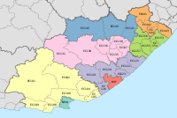
Mhlontlo Local Municipality

Last updated

Mhlontlo
Mhlontlo CoA.png
Map of the Eastern Cape with Mhlontlo highlighted.svg
Location in the Eastern Cape
Country South Africa
Province Eastern Cape
District OR Tambo
Seat Qumbu
Wards 26
Government
[1]
  Type Municipal council
  MayorCllr Mbulelo Jara (ANC)
  SpeakerCllr Eddie Pula (ANC)
  Chief WhipCllr Ntombikayise Gcaba (ANC)
Area
  Total2,826 km2 (1,091 sq mi)
Population
 (2022) [2]
  Total186,391
  Density66/km2 (170/sq mi)
Racial makeup (2011)
[2]
   Black African 97.6%
   Coloured 0.3%
   Indian/Asian 0.2%
   White 0.1%
First languages (2011)
[2]
   Xhosa 94.9%
   English 2.3%
  Other2.8%
Time zone UTC+2 (SAST)
Municipal codeEC156

Mhlontlo Municipality (Xhosa : uMasipala wase Mhlontlo) is a local municipality within the OR Tambo District Municipality, in the Eastern Cape province of South Africa.

Contents

The Mhlontlo Municipality is a municipality situated along the N2 national route between Mthatha and KwaBhaca. It encompasses the towns of Qumbu and Tsolo, together with the surrounding villages. There are three hospitals within the municipality; the Nessie Knight Hospital in Sulenkama village (Qumbu), the St Lucy Hospital in Ngcolosi village (Tsolo) and the Dr Malizo Mpehle Hospital near the town of Tsolo. The municipality is the seat of the AmaMpondomise Kingdom, which seats at Lower Kroza village near Qumbu.

Mhlontlo was a king of the AmaMpondomise people during the 19th century. [3]

Main places

The 2001 census divided the municipality into the following main places: [4]

PlaceCodeArea (km2)Population
Amacwera 23501 177.8220,419
Amampondomise 23502 109.2412,566
Amazizi 23503 0.350
Asentshonalanga 23504 8.02475
Basuto 23505 7.950
Bhele 23506 70.314,240
Bovube 23507 197.1918,717
Culunca 23508 99.509,501
Ebotwa 23509 203.3522,254
Emaqa-Kambani 23510 162.7110,214
Hala 23511 67.982,907
Hlubi 23512 280.7722,631
Kambi 23513 6.87369
Ketani 23514 70.067,600
Lwandlolubomvu 23515 48.431,625
Makaula 23516 24.83629
Masizakhe 23517 293.6718,661
Matolandile/Zimelelandile 23518 32.9152
Mbalisweni 23519 125.2210,021
Mhlontlo 23520 19.826
Ngqubusini 23521 106.955,855
Ngwane 23522 16.95633
Northern Pondomise 23523 294.5015,987
Qumbu 23524 38.153,275
Tsolo Part 1 23525 53.975,678
Tsolo Part 2 23526 184.592,361

Politics

The municipal council consists of fifty-one members elected by mixed-member proportional representation. Twenty-six councillors are elected by first-past-the-post voting in twenty-six wards, while the remaining twenty-five are chosen from party lists so that the total number of party representatives is proportional to the number of votes received. In the election of 1 November 2021 the African National Congress (ANC) won a majority of forty seats on the council. The following table shows the results of the election. [5]

PartyWardListTotal
seats
Votes%SeatsVotes%Seats
African National Congress 29,81671.692532,00177.741540
United Democratic Movement 2,2185.3302,7496.6833
Economic Freedom Fighters 2,2945.5202,4916.0533
Independent candidates 4,43610.6711
African Transformation Movement 1,7574.2201,8104.4022
Independent South African National Civic Organisation 3330.8001,2533.0411
Democratic Alliance 6121.4706091.4811
Batho Pele Movement 1200.290980.2400
Civic Independent 20.0001530.3700
Total41,588100.002641,164100.002551
Valid votes41,58897.0241,16497.06
Invalid/blank votes1,2762.981,2462.94
Total votes42,864100.0042,410100.00
Registered voters/turnout93,16446.0193,16445.52

Related Research Articles

<span class="mw-page-title-main">George Local Municipality</span> Local municipality in Western Cape, South Africa

George Municipality is a local municipality within the Garden Route District Municipality, in the Western Cape province of South Africa. As of 2011, the population is 193,672. Its municipality code is WC044.
<span class="mw-page-title-main">Tswaing Local Municipality</span> Local municipality in North West, South Africa

Tswaing Municipality is a local municipality within the Ngaka Modiri Molema District Municipality, in the North West province of South Africa. It consists of the towns of Delareyville, Sannieshof and Ottosdal.

<span class="mw-page-title-main">KwaDukuza Local Municipality</span> Local municipality in KwaZulu-Natal, South Africa

KwaDukuza Local Municipality is one of four municipalities under iLembe District Municipality, KwaZulu-Natal, South Africa.
<span class="mw-page-title-main">Mbhashe Local Municipality</span> Local municipality in Eastern Cape, South Africa

Mbhashe Municipality is a local municipality in the Eastern Cape province of South Africa. The municipality was constituted in terms of the Municipal Structures Act of 1998 and comprises the areas that previously formed the Elliotdale, Willowvale and Dutywa town councils. The municipality is located in the north eastern part of the Amathole District Municipality. The main administrative office is situated in Dutywa.

<span class="mw-page-title-main">Karoo Hoogland Local Municipality</span> Local municipality in Northern Cape, South Africa

Karoo Hoogland Municipality is a local municipality within the Namakwa District Municipality, in the Northern Cape province of South Africa. The municipality incorporates the towns of Williston, Fraserburg and Sutherland. Although the towns are separated by more than 100 km by road, they share many administrative tasks.

uMhlathuze Local Municipality Local municipality in KwaZulu-Natal, South Africa

uMhlathuze Local Municipality is an administrative area in the King Cetshwayo District Municipality of KwaZulu-Natal in South Africa. The municipality is named after the Mhlatuze River.

<span class="mw-page-title-main">Maphumulo Local Municipality</span> Local municipality in KwaZulu-Natal, South Africa

Maphumulo Local Municipality is an administrative area in the iLembe District of KwaZulu-Natal in South Africa. Maphumulo is an isiZulu name meaning "place of rest".

<span class="mw-page-title-main">Blue Crane Route Local Municipality</span> Local municipality in Eastern Cape, South Africa

Blue Crane Route Municipality is a local municipality within the Sarah Baartman District Municipality, in the Eastern Cape of South Africa. The municipality is named after the South African national bird, the blue crane.

<span class="mw-page-title-main">Elundini Local Municipality</span> Local municipality in Eastern Cape, South Africa

Elundini Municipality is a local municipality within the Joe Gqabi District Municipality, in the Eastern Cape province of South Africa. The name originates from isiZulu and refers to the Drakensberg Mountains.

<span class="mw-page-title-main">Mtubatuba Local Municipality</span> Local municipality in KwaZulu-Natal, South Africa

Mtubatuba Municipality is a local municipality within the Umkhanyakude District Municipality, in the KwaZulu-Natal province of South Africa.

<span class="mw-page-title-main">Emalahleni Local Municipality, Eastern Cape</span> Local municipality in Eastern Cape, South Africa

Emalahleni Municipality is a local municipality within the Chris Hani District Municipality, in the Eastern Cape province of South Africa. Emalahleni is an isiXhosa word meaning "a place of coal".

<span class="mw-page-title-main">Hlabisa Local Municipality</span> Local municipality in KwaZulu-Natal, South Africa

Hlabisa was an administrative area in the Umkhanyakude District of KwaZulu-Natal in South Africa. Hlabisa is an isiZulu surname of the two nkosis (kings) in the area. The municipality was situated within the vicinity of four Tribal Authorities which are the Mkhwanazi Tribal Authority, the Mdletshe Tribal Authority, and two Hlabisa Tribal Authorities.
uMlalazi Local Municipality Local municipality in KwaZulu-Natal, South Africa

uMlalazi Local Municipality is an administrative area in the King Cetshwayo District of KwaZulu-Natal in South Africa. The municipality is named after the uMlalazi River.

<span class="mw-page-title-main">Lukhanji Local Municipality</span> Former local municipality in Eastern Cape, South Africa

Lukhanji Local Municipality was an administrative area in the Chris Hani District of the Eastern Cape in South Africa. Lukhanji is a Xhosa name for the mountain that runs from the eastern side of Queenstown to the western side. After municipal elections on 3 August 2016 it was merged into the larger Enoch Mgijima Local Municipality.

<span class="mw-page-title-main">Dr AB Xuma Local Municipality</span> Local municipality in Eastern Cape, South Africa

Dr AB Xuma Local Municipality is a local municipality within the Chris Hani District Municipality, in the Eastern Cape province of South Africa. Ngcobo is an isiXhosa word for a sweet grass found in the area.

<span class="mw-page-title-main">Mthonjaneni Local Municipality</span> Local municipality in KwaZulu-Natal, South Africa

Mthonjaneni is an administrative area in the King Cetshwayo District of KwaZulu-Natal in South Africa.

<span class="mw-page-title-main">Ubuhlebezwe Local Municipality</span> Local municipality in KwaZulu-Natal, South Africa

Ubuhlebezwe Municipality is a local municipality within the Harry Gwala District Municipality, in the KwaZulu-Natal province of South Africa. Ubuhlebezwe is an isiZulu word meaning "the beauty of the land". The name is derived from Alan Paton's novel, Cry, The Beloved Country.

<span class="mw-page-title-main">Qumbu</span> Place in Eastern Cape, South Africa

Qumbu is a town in OR Tambo District Municipality in the Eastern Cape province of South Africa.

<span class="mw-page-title-main">AmaMpondomise</span> Ethnic group

The Mpondomise people, also called Ama-Mpondomise, are a Xhosa-speaking people. Their traditional homeland has been in the contemporary era Eastern Cape province of South Africa, during apartheid they were located both in the Ciskei and Transkei region. Like other separate Xhosa-speaking kingdoms such as Aba-Thembu and Ama-Mpondo, they speak Xhosa and are at times considered as part of the Xhosa people.

The Mhlontlo Local Municipality council consists of fifty-one members elected by mixed-member proportional representation. Twenty-six councillors are elected by first-past-the-post voting in twenty-six wards, while the remaining twenty-five are chosen from party lists so that the total number of party representatives is proportional to the number of votes received. In the election of 1 November 2021 the African National Congress (ANC) won a majority of forty seats.

References

  1. "Contact list: Executive Mayors". Government Communication & Information System. Archived from the original on 14 July 2010. Retrieved 22 February 2012.
  2. 1 2 3 "Statistics by place". Statistics South Africa. Retrieved 27 September 2015.
  3. South African Languages - Place names
  4. Lookup Tables - Statistics South Africa [ permanent dead link ]
  5. "Election Result Table for LGE2021 — Mhlontlo". wikitable.frith.dev. Retrieved 24 February 2022.

31°09′S28°52′E / 31.150°S 28.867°E / -31.150; 28.867