N11 (South Africa)

Last updated

SA road N11.svg
National route N11
Map of the N11 (South Africa) with labels.svg
Route information
Maintained by SANRAL
Length773 km (480 mi)
Major junctions
North end Botswana border at Groblersbrug
Major intersectionsSA road N1 jct.svg N1 near Mokopane
SA road N4 jct.svg N4 near Middelburg
SA road N2 jct.svgSA road N17 jct.svg N2  / N17 in Ermelo
South endSA road N3 jct.svg N3 near Ladysmith
Location
Country South Africa
Provinces Limpopo, Mpumalanga, KwaZulu-Natal
Towns
Highway system
SA road N10.svg N10 SA road N12.svg N12

The N11 is a national route in South Africa which runs from the Botswana border at Groblersbrug, through Mokopane, Middelburg, Ermelo and Newcastle to end at the N3 just after Ladysmith. [1]

Contents

Route

Limpopo

The N11 begins at the Grobler's Bridge Border with Botswana on the Limpopo River. On the Botswana side of the Limpopo River, the border post is known as Martin's Drift.

It begins by running south-east through Limpopo province for 190 kilometres to Mokopane. Just before entering Mokopane, the N11 is joined by the R518 and they form one road into Mokopane Central.

At the junction with the R101 road (Thabo Mbeki Drive), the N11 and the R518 join the R101 southwards. At the second junction afterwards (by Mokopane Mall), the R518 becomes its own road eastwards towards Zebediela, leaving the R101 and the N11 as the road southwards (Thabo Mbeki Drive). After 11 kilometres, the N11 becomes its own road towards the south-south-east and meets the N1 highway (southbound only) at the next junction just north of the N1's Nyl Toll Plaza.

The N11 continues southwards for 72 kilometers to reach an intersection with the R33 road. The R33 joins the N11 and they become one road southwards into the town of Marble Hall (15 kilometres), where they meet the north-eastern terminus of the R573 from Pretoria and KwaMhlanga. The R33 and N11 remain as one road for another 27 kilometres south into the town of Groblersdal.

At the junction with the north-eastern terminus of the R25 road (4-way junction; staggered junction) in Groblersdal, the R33 becomes the road eastwards, leaving the N11 as the road southwards. The N11 continues southwards for 85 kilometers, following the Olifants River, to cross into the Mpumalanga Province and reach the city of Middelburg.

Mpumalanga

It enters the city of Middelburg as Walter Sisulu Street. At the junction with Cowen Ntuli Street, the N11 meets the R555 and the R104 and they all become the road eastwards on Cowen Ntuli Street, which is the main road through Middelburg Central.

Just after meeting the R35 road's northern terminus, the R555 becomes its own road north-eastwards, leaving the R104 and N11 as the road eastwards. Just after the Eastdene suburb, the N11 splits from the R104 to become the road towards the south-east. After the Nazareth and Rockdale suburbs, it meets the N4 highway (Pretoria-Maputo Highway; Maputo Corridor). The N11 proceeds south-south-east for 55 kilometres to the town of Hendrina, where it passes through the town as Church Street and intersects with the R38 road (Beukes Street) in the town centre. It proceeds south-east for 50 kilometres to the city of Ermelo, where it meets the N17 from Eswatini (Swaziland).

The route between Hendrina and Ermelo, Mpumalanga N11-pad tussen Hendrina en Ermelo, Mpumalanga, a.jpg
The route between Hendrina and Ermelo, Mpumalanga

At the Fourie Street junction, the N17 joins the N11 southwards up to the junction with Joubert Street, where the N17 continues westwards. At Voortrekker Street south of Ermelo town centre, the N11 meets the terminus of the N2 from Piet Retief, St. Lucia and Durban. From Ermelo, the N11 runs south for 97 kilometres, through Amersfoort (where it meets the R35 road again), to the town of Volksrust, where it meets the south-eastern terminus of the R23 road and becomes the Laing's Nek Pass. Just after, the N11 enters KwaZulu-Natal.

KwaZulu-Natal

From Volksrust, the N11 proceeds south for 45 kilometres to reach the city of Newcastle. Just before Newcastle, the N11 is joined by the R34 for 7 kilometres until they split at an off-ramp north-east of the city centre, where the N11 becomes the Newcastle Eastern Bypass. After bypassing the city centre, the N11 proceeds south for 95 kilometres as the Ikhupe Pass, meeting the western terminus of the R68 (which connects to Dundee), to reach the city of Ladysmith. It crosses the Klip River in the city centre and turns westwards to reach an off-ramp intersection with the R103 road adjacent to the Ladysmith Airport entrance. The N11 joins the R103 and they are one road south-south-west for 2 and a half kilometers before the N11 becomes its own road westwards. The N11 heads westwards for 13 kilometres, meeting the north-eastern terminus of the R600 (which connects to Winterton), to reach its end at an off-ramp junction with the N3 highway just south of the N3's Tugela Toll Plaza (each ramp onto the N3 has a tollgate). West of this junction, it continues as the R616 to Bergville.

Related Research Articles

<span class="mw-page-title-main">R23 (South Africa)</span>

The R23 is a provincial route in South Africa that links Benoni with Volksrust via Brakpan, Heidelberg and Standerton.

<span class="mw-page-title-main">R26 (South Africa)</span>

The R26 is a provincial route in Free State, South Africa that connects Rouxville with Villiers via Zastron, Wepener, Ladybrand, Ficksburg, Bethlehem & Reitz.

<span class="mw-page-title-main">R29 (South Africa)</span> Road in South Africa

The R29 is a provincial route in South Africa that connects Johannesburg with Leandra and Kinross via Germiston, Boksburg, Benoni and Springs. For much of its route it is named Main Reef Road. The R29 used to end near the Golela border post, however the section from Evander to Ermelo is now part of the N17 and the section from Ermelo to the Golela border post just after Pongola is now part of the N2.

<span class="mw-page-title-main">R33 (South Africa)</span> Road in South Africa

The R33 is a provincial route in South Africa that connects Pietermaritzburg with Lephalale via Greytown, Paulpietersburg, Carolina, Belfast and Vaalwater. It is a very long road, passing through 3 provinces.

<span class="mw-page-title-main">R34 (South Africa)</span> Road in South Africa

The R34 is a long provincial route in South Africa that connects Vryburg with Richards Bay via Kroonstad and Newcastle. It passes through three provinces, North West, the Free State and KwaZulu-Natal.

<span class="mw-page-title-main">R35 (South Africa)</span>

The R35 is a provincial route in Mpumalanga, South Africa that connects Amersfoort with Middelburg via Morgenzon and Bethal. The R35 used to connect with the N3 near Ladysmith, but the portion of the road from Amersfoort onwards is now part of the N11.

<span class="mw-page-title-main">R36 (South Africa)</span>

The R36 is a provincial route in South Africa that connects the N1 at Bandelierkop with Ermelo, via Tzaneen and Lydenburg. It is co-signed with the N4 for 8 kilometres between Machadodorp and Patattanek, with a tollgate on this section. It used to extend further south past Ermelo to Amersfoort, but that section is now designated as part of the N11.

<span class="mw-page-title-main">R37 (South Africa)</span>

The R37 is a provincial route in South Africa that connects Polokwane with Nelspruit (Mbombela) via Burgersfort and Lydenburg.

<span class="mw-page-title-main">R38 (South Africa)</span>

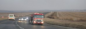
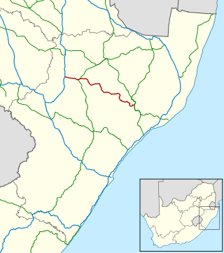
The R38 is a provincial route in South Africa that connects Standerton with Kaapmuiden via Bethal, Carolina and Barberton. It is a main route through the province of Mpumalanga.

<span class="mw-page-title-main">R56 (South Africa)</span> Road in South Africa

The R56 is a provincial route in South Africa that connects Middelburg with Pietermaritzburg via Molteno, Maclear and Kokstad. It is co-signed with the N2 between Kokstad and Stafford's Post for 39 kilometres.

<span class="mw-page-title-main">R68 (South Africa)</span>

The R68 is a provincial route in KwaZulu-Natal, South Africa that connects Melmoth with Dundee.

<span class="mw-page-title-main">R71 (South Africa)</span>

The R71 is a provincial route in Limpopo, South Africa that connects Polokwane with the Kruger National Park via Tzaneen and Phalaborwa.

The R103 is a Regional Route in South Africa that is the designation for some of the old sections of roads that were previously the N3, prior to upgrading. It only has 3 sections, from Hillcrest to Ladysmith, from Warden to Villiers and from Heidelberg to Johannesburg.

The R104 is a regional route in South Africa that is the designation for some of the old sections of roads that were previously the N4, prior to upgrading. It connects Rustenburg in the North West province with Witbank in Mpumalanga province via Mooinooi, Hartbeespoort, Pretoria and Bronkhorstspruit. There is also a 50km section in Mpumalanga province connecting Middelburg and Wonderfontein.

<span class="mw-page-title-main">N4 (South Africa)</span> National road in South Africa

The N4 is a national route in South Africa that runs from Skilpadshek on the Botswana border, past Rustenburg, Pretoria, eMalahleni and Mbombela, to Komatipoort on the Mozambique border. The entire route is a toll road.

<span class="mw-page-title-main">N17 (South Africa)</span> National road in South Africa

The N17 is a national route in South Africa which runs from Johannesburg to Oshoek (Ngwenya) on the border with Eswatini. It passes through Springs, Bethal and Ermelo.

The R101 is a Regional Route in South Africa that is the designation for some of the old sections of roads that were previously the N1, prior to upgrading. It only has 2 sections, from Bellville to Worcester and from Johannesburg to Polokwane.

<span class="mw-page-title-main">R518 (South Africa)</span>

The R518 is a Regional Route in South Africa that connects Lephalale with Zebediela via Mokopane.

The R555 is a Regional Route in South Africa that connects Springs with Ohrigstad via Delmas, Ogies, Witbank, Middelburg, Stoffberg and Burgersfort.

The M37 is a metropolitan route in Greater Johannesburg, South Africa. It connects the N3 at Greenstone Shopping Mall with Katlehong via Edenvale and Germiston.

References

  1. Falkner, John (May 2012). South African Numbered Route Description and Destination Analysis (Report). National Department of Transport. pp. 25–26. Archived from the original on 6 June 2014. Retrieved 12 August 2014.

25°46′06″S29°27′20″E / 25.768204°S 29.455462°E / -25.768204; 29.455462