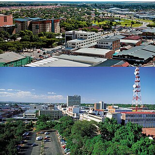
Polokwane, formerly and sometimes also known as Pietersburg, is the capital city of the Limpopo Province in South Africa. It is the country's largest urban centre north of Gauteng. It was one of the nine host cities of the 2010 FIFA World Cup.

South Africa occupies the southern tip of Africa, its coastline stretching more than 2,850 kilometres from the desert border with Namibia on the Atlantic (western) coast southwards around the tip of Africa and then northeast to the border with Mozambique on the Indian (eastern) coast. The low-lying coastal zone is narrow for much of that distance, soon giving way to a mountainous escarpment that separates the coast from the high inland plateau. In some places, notably the province of KwaZulu-Natal in the east, a greater distance separates the coast from the escarpment. Although much of the country is classified as semi-arid, it has considerable variation in climate as well as topography. The total land area is 1,220,813 km2 (471,359 sq mi). It has the 23rd largest Exclusive Economic Zone of 1,535,538 km2 (592,875 sq mi).

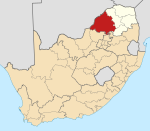
Limpopo is the northernmost province of South Africa. It is named after the Limpopo River, which forms the province's western and northern borders. The capital and largest city in the province is Polokwane, while the provincial legislature is situated in Lebowakgomo.

Andries Hendrik Potgieter, known as Hendrik Potgieter was a Voortrekker leader. He served as the first head of state of Potchefstroom from 1840 and 1845 and also as the first head of state of Zoutpansberg from 1845 to 1852.

Pieter Johannes "Piet" Potgieter was a South African Boer political figure. He was the acting head of state of Zoutpansberg from 1852 to 1854, and the first son of voortrekker Andries Potgieter.
Modimolle, formerly known as Nylstroom, is a town located near the southern edge of the Waterberg Massif in Limpopo province, South Africa. It is a medium-sized town that focuses primarily on agriculture and farming as well as wildlife and tourism. Nylstroom is also located approximately 135 kilometres north of Pretoria, South Africa's capital city.
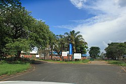
Lephalale, formerly known as Ellisras, is a coal mining town in the Limpopo province of South Africa immediately east of the Waterberg Coalfield. The town was established as Ellisras in 1960 and named after Patrick Ellis and Piet Erasmus who settled on a farm there in the 1930s. In 2002, Ellisras was renamed Lephalale by the provincial government of Limpopo, after the main river that crosses the municipality. Lephalale is derived from the setswana language meaning "to flow".

The Bushveld is a sub-tropical woodland ecoregion of Southern Africa. The ecoregion straddles the Tropic of Capricorn and constitutes the southern part of the Zambezian region. It encompasses most of Limpopo and a small part of North West in South Africa, the Central and North-East Districts of Botswana and the Matabeleland South and part of Matabeleland North provinces of Zimbabwe. The Kruger National Park has a number of 'Bushveld' camps, but these are strictly speaking in the lowveld, as these terms are sometimes used interchangeably. Although their limits are somewhat blurred, lowveld is generally restricted to the more easterly parts of South Africa and Zimbabwe.

The Magaliesberg of northern South Africa, is a modest but well-defined mountain range composed mainly of quartzites. It rises at a point south of the Pilanesberg to form a curved prominence that intersects suburban Pretoria before it peters out some 50 km (31 mi) to the east, just south of Bronkhorstspruit. The highest point of the Magaliesberg is reached at Nooitgedacht, about 1,852 metres (6,076 ft) above sea level. A cableway reaching to the top of the mountain range is located at Hartbeespoort Dam, providing sweeping views of the Magaliesberg and surrounding area.

The Soutpansberg, meaning "Salt Pan Mountain" in Afrikaans, is a range of mountains in far northern South Africa. It is located in Vhembe District, Limpopo. It is named for the salt pan located at its western end. The mountain range reaches the opposite extremity in the Matikwa Nature Reserve, some 107 kilometres (66 mi) due east. The range as a whole had no Venda name, as it was instead known by its sub-ranges which include Dzanani, Songozwi and others.

The Waterberg is a mountainous massif of approximately 654,033 hectare in north Limpopo Province, South Africa. The average height of the mountain range is 600 m with a few peaks rising up to 2,000 m above sea level. Vaalwater town is located just north of the mountain range. The extensive rock formation was shaped by hundreds of millions of years of riverine erosion to yield diverse bluff and butte landform. The ecosystem can be characterised as a dry deciduous forest or Bushveld. Within the Waterberg there are archaeological finds dating to the Stone Age, and nearby are early evolutionary finds related to the origin of humans.
Mahwelereng is a township in the Mogalakwena Local Municipality of the Waterberg District Municipality of the Limpopo Province of South Africa, It is about 2 km from Mokopane. The township is a product of Apartheid South Africa's policies in the former Bantustan of Lebowa. Most of the original residents of Mahwelereng were from an area which old residents call "Ol' Location". Ol' Location was too close to town and the residents had to be moved further away from town. There are still remnants of Ol' Location such as the "Bar" and the Lutheran Church Mission on the Sekgakgapeng site. The township is bordered by Sekgakgapeng, Mountainview, Moshate, Phola Park, and Ga-Madiba.
Makapansgat is an archaeological location within the Makapansgat and Zwartkrans Valleys, northeast of Mokopane in Limpopo province, South Africa. It is an important palaeontological site, with the local limeworks containing Australopithecus-bearing deposits dating to between 3.0 and 2.6 million years BP. The whole Makapan Valley has been declared a South African Heritage Site. Makapansgat belongs to the Cradle of Humankind.
Mosesetjane is a village situated northwest of the town of Mokopane in the Waterberg District of the Limpopo province of South Africa. It is divided into three sections under three chiefs: Chief Kekana of the Kgobudi section, Chief Frans Ledwaba of the Sekgoboko section, and Chief N Lebelo of the Mmalepetleke area.
The R101 is a Regional Route in South Africa that is the designation for some of the old sections of roads that were previously the N1, prior to upgrading. It only has 2 sections, from Bellville to Worcester and from Johannesburg to Polokwane.
The Bobirwa Subdistrict is a jurisdiction in Botswana. It is populated by the Babirwa (Ba-Birwa) people who came from Transvaal in present-day South Africa.
Schoemansdal was a settlement situated 16 km west of Louis Trichardt (Makhado), which had its origins during the Great Trek. It existed from 1848 to 1867, and functioned as the capital of an autonomous region until the S.A.R. Volksraad was established, when the outpost came under the supervision and regulations of the central government. The settlement was evacuated after only thirty years when attacked by Venda militants. The government rendered indecisive support and the town as torched by Katze-Katze on the night of 15 July 1867.
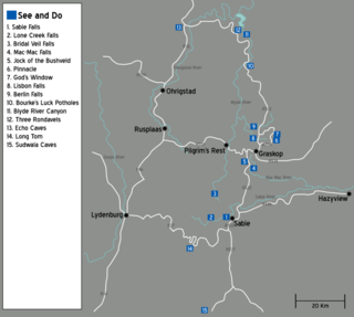
The Panorama Route is a scenic road in South Africa connecting several cultural and natural points of interest. The route, steeped in the history of South Africa, is in Mpumalanga province, centred around the Blyde River Canyon, the world's third largest canyon. It features numerous waterfalls, one of the largest afforested areas in South Africa, and several natural landmarks. The route starts at the foot of the Long Tom Pass just outside Lydenburg, following the natural descent from the Great Escarpment to the Lowveld, and ending at the border of the Mpumalanga and Limpopo provinces near the Echo Caves.
Masehlaneng is a village situated northwest of the town of Mokopane in the Waterberg District of the Limpopo province of South Africa. It is about 8 km from Mokopane, which is two hours from Gauteng by road. The population is multiethnic. The dominant languages in the area are Northern Sotho and Northern Ndebele.