The Province of the Transvaal, commonly referred to as the Transvaal, was a province of South Africa from 1910 until 1994, when a new constitution subdivided it following the end of apartheid. The name "Transvaal" refers to the province's geographical location to the north of the Vaal River. Its capital was Pretoria, which was also the country's executive capital.

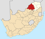
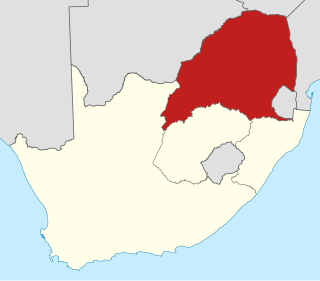
Limpopo is the northernmost province of South Africa. It is named after the Limpopo River, which forms the province's western and northern borders. The capital and largest city in the province is Polokwane.

Modimolle, formerly known as Nylstroom, is a town located near the southern edge of the Waterberg Massif in Limpopo province, South Africa. It is a medium-sized town that focuses primarily on agriculture and farming as well as wildlife and tourism. Nylstroom is also located approximately 135 kilometres north of Pretoria, South Africa's capital city.
Lephalale is a coal mining town in the Limpopo province of South Africa immediately east of the Waterberg Coalfield. The town was established as Ellisras in 1960 and named after Patrick Ellis and Piet Erasmus who settled on a farm there in the 1930s. In 2002, Ellisras was renamed Lephalale by the provincial government of Limpopo, after the main river that crosses the municipality. Lephalale is divided into three main subsections, Ellisras, Onverwacht and Marapong. Lephalale is derived from the setswana language meaning "to flow".

Thabazimbi is an iron mining town in the Limpopo province of South Africa. The town is at the feet of the Ysterberg and is surrounded by the Witfonteinrand and Boshofberg with the majestic Kransberg in the background. The name Thabazimbi means mountain of iron because of the large iron ore reef that was discovered in 1919 by J. H. Williams. The mine boasts one of the largest mining shafts in Africa. More than 2 million tons of ore are mined every year and hauled by train to Mittal's iron and steel works. The railway line from Rustenburg reached the area in the 1930s and full scale iron and steel production began. The town was proclaimed in 1953. Kumba Iron Ore, previously Kumba Resources, is now the principal operator of the iron ore mine.

Vaalwater is a small town situated on the Mokolo River in the Limpopo province of South Africa.
Bela-Bela is a town in the Limpopo Province of South Africa. Deriving its name from the geothermic hot springs around which the town was built, it was called Warmbaths, until 2002.

Mokopane, is a town in the Limpopo province of South Africa.

The Bushveld is a sub-tropical woodland ecoregion of Southern Africa. It encompasses most of Limpopo Province and a small part of the North West Province of South Africa, the Central and North-East Districts of Botswana and the Matabeleland South and part of the Matabeleland North provinces of Zimbabwe. Kruger National Park in South Africa has a number of 'Bushveld' camps. The terms 'bushveld' and 'lowveld' are sometimes used interchangeably, and the line between the two is somewhat blurred, although the lowveld lies in Mpumalanga.
The Battle of Waterberg took place on August 11, 1904 at the Waterberg, German South West Africa, and was the decisive battle in the German campaign against the Herero.
Nkangala is one of the 3 districts of Mpumalanga province of South Africa. The seat of Nkangala is Middelburg. The Nkangala District Municipality consists of 160 towns and villages. The most spoken language of its 1,308,129 people is IsiNdebele with 28.4%, closely followed by Zulu speakers. The district code is DC31.
Capricorn is one of the 5 districts of Limpopo province of South Africa. The district is named after the Tropic of Capricorn which runs through it. The capital of Capricorn is Polokwane. The vast majority of its 1,261,463 people speak Northern Sotho as their home language. The district code is DC35.

Waterberg is one of the 5 districts of Limpopo province of South Africa. The seat of Waterberg is Modimolle. The majority of its 745 758 people speak Sepedi, also known as Northern Sotho. The district code is DC36.

The Waterberg is a mountainous massif of approximately 654,033 hectare in north Limpopo Province, South Africa. The average height of the mountain range is 600 m with a few peaks rising up to 2000 m above sea level. Vaalwater town is located just north of the mountain range. The extensive rock formation was shaped by hundreds of millions of years of riverine erosion to yield diverse bluff and butte landform. The ecosystem can be characterised as a dry deciduous forest or Bushveld. Within the Waterberg there are archaeological finds dating to the Stone Age, and nearby are early evolutionary finds related to the origin of humans.

The Mokolo River is a major watercourse in Limpopo Province of South Africa. This river collects much of the drainage of the Waterberg Massif and discharges it to the Limpopo River. The river's catchment area comprises 8,387 square kilometres (3,238 sq mi).
Heroes' Day is a national public holiday in Namibia. It is recognized by the United Nations as Namibia Day. Celebrated annually on 26 August, the day commemorates the Namibian War of Independence which began on 26 August 1966 at Omugulugwombashe.
Northam is a town in the Waterberg District Municipality in the Limpopo province of South Africa, 54 km south of Thabazimbi.
Middeldrift is a village in Waterberg District Municipality in the Limpopo province of South Africa.
The Ellisras Basin is a geological basin that spans the border between South Africa and Botswana, extending west from the town of Lephalale in Limpopo province. Basin fill consists of sedimentary rocks of the Karoo Supergroup, with maximum thickness of 1,500 metres (4,900 ft).
Eseldrift is a town in Waterberg District Municipality in the Limpopo province of South Africa.