A ghost town, deserted city, extinct town or abandoned city is an abandoned village, town, or city, usually one that contains substantial visible remaining buildings and infrastructure such as roads. A town often becomes a ghost town because the economic activity that supported it has failed or ended for any reason. The town may also have declined because of natural or human-caused disasters such as floods, prolonged droughts, extreme heat or extreme cold, government actions, uncontrolled lawlessness, war, pollution, or nuclear disasters. The term can sometimes refer to cities, towns, and neighborhoods that, though still populated, are significantly less so than in past years; for example, those affected by high levels of unemployment and dereliction.

A village is a clustered human settlement or community, larger than a hamlet but smaller than a town, with a population typically ranging from a few hundred to a few thousand. Although villages are often located in rural areas, the term urban village is also applied to certain urban neighborhoods. Villages are normally permanent, with fixed dwellings; however, transient villages can occur. Further, the dwellings of a village are fairly close to one another, not scattered broadly over the landscape, as a dispersed settlement.

Tinley Park is a village in Cook County, Illinois, United States, with a small portion in Will County. The village is a suburb of Chicago. Per the 2020 census, the population was 55,971. It is one of the fastest growing suburbs southwest of Chicago. In 2009 BusinessWeek named Tinley as the best place in America to raise a family.

South Orange, officially the Township of South Orange Village, is a suburban township in Essex County, in the U.S. state of New Jersey. As of the 2020 United States census, the township's population was 18,484, an increase of 2,286 (+14.1%) from the 2010 census count of 16,198, which in turn reflected a decline of 766 (−4.5%) from the 16,964 counted in the 2000 census. Seton Hall University is located in the township.

South Kingstown is a town in, and the county seat of, Washington County, Rhode Island, United States. The population was 31,931 at the 2020 census. South Kingstown is the second largest town in Rhode Island by total geographic area, behind New Shoreham, and the third largest town in Rhode Island by geographic land area, behind Exeter and Coventry.

Notre Dame is a census-designated place and unincorporated community north of the city of South Bend in St. Joseph County, in the U.S. state of Indiana. It includes the campuses of three colleges: the University of Notre Dame, Saint Mary's College, and Holy Cross College. Notre Dame is split between Clay and Portage Townships. As of the 2020 census, its population was 7,234.
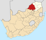
Carletonville is a town in Gauteng and the seat of the Merafong City Local Municipality in the West Rand District Municipality in Gauteng, South Africa, just north of the richest gold-mining area in the world. At 3,749 m, Western Deep Levels holds the record for the world's deepest gold mine.

Lesedi Cultural Village is a tourist village which celebrates the cultural traditions of several different peoples of Southern Africa. It reproduces traditional dwellings and offers demonstrations of dances and other cultural activities. It is situated near Johannesburg, within the Cradle of Humankind, in Gauteng, South Africa.
Patharpratima is a community development block that forms an administrative division in Kakdwip subdivision of South 24 Parganas district in the Indian State of West Bengal.
Mandirbazar is a community development block that forms an administrative division in Diamond Harbour subdivision of South 24 Parganas district in the Indian State of West Bengal.
Thakurpukur Maheshtala is a community development block that forms an administrative division in the Alipore Sadar subdivision of South 24 Parganas district in the Indian state of West Bengal.
Jaynagar II is a community development block that forms an administrative division in the Baruipur subdivision of the South 24 Parganas district in the Indian state of West Bengal.
Kultali is a community development block that forms an administrative division in the Baruipur subdivision of the South 24 Parganas district in the Indian state of West Bengal.
Sonarpur is a community development block that forms an administrative division in the Baruipur subdivision of the South 24 Parganas district in the Indian state of West Bengal.
Diamond Harbour I is a community development block that forms an administrative division in the Diamond Harbour subdivision of the South 24 Parganas district in the Indian state of West Bengal.
Diamond Harbour II is a community development block that forms an administrative division in the Diamond Harbour subdivision of the South 24 Parganas district in the Indian state of West Bengal.
Kulpi is a community development block that forms an administrative division in Diamond Harbour subdivision of South 24 Parganas district in the Indian State of West Bengal.

Middledrift, officially known as iXesi and also known as Middeldrift, is a small town located 90 kilometres (60 mi) north-west of East London in the Eastern Cape province of South Africa. It is situated in Raymond Mhlaba Municipality in Amathole District in an area that was formerly part of the Ciskei.
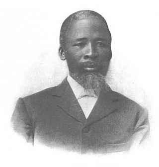
James Mata Dwane, priest and founder of the Order of Ethiopia.