isiNdebele, also known as Southern Ndebele or isiNdebele sakwaNdzundza noManala, is an African language belonging to the Nguni group of Bantu languages, spoken by the Ndebele people of South Africa.

KwaZulu-Natal is a province of South Africa that was created in 1994 when the Zulu bantustan of KwaZulu and Natal Province were merged. It is located in the southeast of the country, with a long shoreline on the Indian Ocean and sharing borders with three other provinces and the countries of Mozambique, Eswatini and Lesotho. Its capital is Pietermaritzburg, and its largest city is Durban. It is the second-most populous province in South Africa, with slightly fewer residents than Gauteng.

Mpumalanga is a province of South Africa. The name means "East", or literally "The Place Where the Sun Rises" in the Nguni languages. Mpumalanga lies in eastern South Africa, bordering Eswatini and Mozambique. It shares borders with the South African provinces of Limpopo to the north, Gauteng to the west, the Free State to the southwest, and KwaZulu-Natal to the south. The capital is Mbombela.

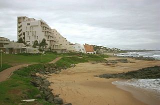
eMdloti, alternatively rendered Umdloti and also known as Umdloti Beach, is a small resort village situated along the KwaZulu-Natal North Coast, South Africa. It lies at the mouth of the Mdloti River approximately 24 km north-east of Durban and 11 km north-east of uMhlanga and now forms part of eThekwini, the Greater Durban Metropolitan Municipality.
Loopspruit is a small town situated 55 km north east of Pretoria in Mpumalanga, South Africa.

KwaNdebele was a bantustan in South Africa, intended by the apartheid government as a semi-independent homeland for the Ndebele people. The homeland was created when the South African government purchased nineteen white-owned farms and installed a government.

AmaZulu Football Club is a South African professional soccer club based in the city of Durban in the KwaZulu Natal province, that plays in the Premier Soccer League the first-tier of South African football league system. The club's nickname, Usuthu, is a Zulu war cry.

Vaalbank is a small town some 102 kilometers northeast of Pretoria. The town is an important one in Mpumalanga's northwestern end where the majority of the surrounding population is rural and does not have infrastructure. It overlooks the Mkhombo Dam which is of agricultural importance in the region.

uMhlanga, alternatively rendered Umhlanga, is a residential, commercial and resort town north of Durban on the coast of KwaZulu-Natal, South Africa. It is part of the eThekwini Metropolitan Municipality, which was created in 2000 and includes the greater Durban area. The name means "place of reeds" in the Zulu language, and the correct pronunciation of "hl" in uMhlanga is similar to the Welsh "ll".

Lupane ( luːpɑːnɛ) District is located in the Matabeleland North Province of Zimbabwe, and it is also the Provincial Capital. The District is situated at an elevation of 976 m with a population of 107,000 inhabitants by 2022. Lupane Town is the main center of the district located 172 km from Bulawayo along the A8 Victoria Falls Road. The Government Provincial Administrative offices are located at the Town Centre. A new university near the Town has been established under the name Lupane State University, which caters for the region and beyond. The word Lupane is thought to be a Kalanga or Lozwi word.
Siyabuswa is a township in South Africa in the province of Mpumalanga. During the Apartheid era, Siyabuswa was the capital of the KwaNdebele Bantustan. It served as a capital from 1981 to 1986 when KwaMhlanga replaced it. Most of its inhabitants are members of the Ndebele ethnic group. Currently, Siyabuswa is home to several ethnic groups, namely the Ndebele, Pedi and Sotho people.
La Lucia is a wealthy suburb located in uMhlanga in the KwaZulu-Natal province of South Africa and is situated approximately 14 kilometres north of the Durban CBD. It was named after Lucia Michel. She and her husband Albert Michel founded the sugar cane farm La Lucia.

AmaNdebele are an ethnic group native to South Africa who speak isiNdebele. They mainly inhabit the provinces of Mpumalanga, Gauteng and Limpopo, all of which are in the northeast of the country. In academia this ethnic group is referred to as the Southern Ndebele to differentiate it from their relatives the Northern Ndebele people of Limpopo and Northwest.

Thembisile Hani Municipality is a local municipality within the Nkangala District Municipality, in the Mpumalanga province of South Africa. It is a semi-urban local municipality consisting of 57 villages within which there are 5 established townships.
Kameel-rivier B or Kameelrivier is a village in the low-veld region of KwaNdebele, in the Nkangala District Municipality of the Mpumalanga province of South Africa. The majority of the residents are from the Ndebele people and Sepedi-speaking people. Siyabuswa is its main town. Main family clans include Napo, Masilela, Ramushu, Mahlangu and Skhosana clans.
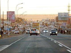
The R573 is a Regional Route in South Africa that connects Pretoria with Marble Hall via KwaMhlanga and Siyabuswa. As the road passes through Moloto, the entire route is known as the Moloto Road. It is maintained by the South African National Roads Agency.
The KwaZulu-Natal North Coast, better known as the North Coast is a coastal region north of Durban in KwaZulu-Natal, South Africa. It stretches from Zinkwazi Beach in the north to Zimbali near Ballito in the south. The coastal region is governed by the KwaDukuza Local Municipality, forming part of the iLembe District Municipality.
Before 1994, South Africa had only four provinces: Cape Province, Natal Province, Orange Free State and Transvaal. Each province had its own identifying lettering: Cape – C, Natal – N, Orange Free State – O and Transvaal – T.

Casric Stars F.C. are a South African football club based at KwaMhlanga in Mpumalanga.