R23 (South Africa)

Last updated

SA road R23.svg
Provincial route R23
Map of the R23 (South Africa).svg
Route information
Maintained by GDRT and SANRAL
Length243 km (151 mi)
Major junctions
North endSA road R25.svg R25 near Kempton Park
Major intersectionsSA road R21.svg R21 near Kempton Park
SA road N12 jct.svg N12 in Benoni
SA road R29.svg R29 in Benoni
SA road N17 jct.svg N17 near Brakpan
SA road N3 jct.svg N3 north of Heidelberg
SA road R42.svg R42 in Heidelberg
SA road N3 jct.svg N3 south of Heidelberg
SA road R51.svg R51 in Balfour
SA road R39.svgSA road R50.svg R39  / R50 in Standerton
South endSA road N11 jct.svg N11 in Volksrust
Location
Country South Africa
Major cities
Highway system
SA road R22.svg R22 SA road R24.svg R24

The R23 is a provincial route in South Africa that links Benoni with Volksrust via Brakpan, Heidelberg and Standerton. [1]

Contents

Route

The R23 begins at the suburb of Birchleigh in the city of Kempton Park, Ekurhuleni, Gauteng at an intersection with the M57 metropolitan route (just south of the M57 route's intersection with the R25). It heads south-east, bypassing the Glen Marais suburb, before crossing the R21 freeway (Pretoria-Boksburg Highway) as High Road. It then crosses the M32 metropolitan route and becomes the road separating the Pomona and Bredell suburbs, before leaving Kempton Park and entering Benoni. The first suburb it passes through is Brentwood Park, where it joins the M45 metropolitan route by way of a left turn onto Great North Road. At the next junction, the M45 becomes the road to the left (east) towards the Rynfield suburb, leaving the R23 as Great North Road south into Benoni central.

It crosses the N12 highway southwards as Tom Jones Street (and as Bunyan Street northwards; one-way streets) and enters Benoni central, bypassing Lakeside Mall. It intersects with the R29 in Benoni central and joins Range View Road southwards by way of a right turn at Mackenzie Park. Soon after, it becomes Heidelberg Road, bypassing Brakpan (co-signed with the M56 metropolitan route for a few metres), and crosses the N17 toll highway at Dalpark, next to where Carnival City is located. By Carnival City, it intersects with Elsburg Road (R554) from Brakpan and proceeds south, bypassing Tsakane, intersecting with the R550 and R103 roads, to cross the N3 toll freeway and enter Heidelberg (the distance from Benoni to Heidelberg is 45 km).

At Heidelberg, it becomes Heidelberg-Balfour Road and bypasses Heidelberg Central to the west, being like a highway passing under some roads. It intersects with the R42 (Nigel-Vereeniging road) at an off-ramp west of the Heidelberg town centre and the northern terminus of the R549 from Deneysville (Vaal Dam) at a t-junction south of the Heidelberg town centre. South of Heidelberg, it crosses back to the east of the N3 toll freeway and heads east-south-east for 35 km towards Balfour in Mpumalanga.

Bypassing Balfour to the south, it intersects with the R51 road at a roundabout and continues south-east for another 75 km, through Greylingstad, to Standerton on the banks of the Vaal River, where it meets the south-eastern terminus of the R50 from Pretoria/Delmas and the south-western terminus of the R39 from Ermelo. At the same junction, it intersects with the R546 from Kinross/Evander. It is cosigned with the R546 for a few kilometres south-east, beginning southwards as Walter Sisulu Drive, then south-east as Nelson Mandela Drive, before they split. Just after crossing the Vaal River, in the suburb of Meyerville, the R546 becomes its own road southwards at the George Street junction while the R23 resumes south-east.

From Standerton, the R23 heads south-east for 85 km to reach its south-eastern terminus in the town of Volksrust, where it ends at a junction with the R543 and the N11.

History

The R23 Route from Heidelberg, Gauteng up to its junction with the N11 National Route in Volksrust used to be part of the N3 National Route, as part of the old National Route system (before 1970). [2] [ citation needed ]

Related Research Articles

<span class="mw-page-title-main">N3 (South Africa)</span> National road in South Africa

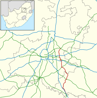
The N3 is a national route in South Africa that connects Johannesburg and Durban, respectively South Africa's largest and third-largest cities. Johannesburg is the financial and commercial heartland of South Africa, while Durban is South Africa's key port and one of the busiest ports in the Southern Hemisphere and is also a holiday destination. Durban is the port through which Johannesburg imports and exports most of its goods. As a result, the N3 is a very busy highway and has a high volume of traffic.

<span class="mw-page-title-main">R21 (South Africa)</span> Road in South Africa

The R21 is a major north–south provincial route in eastern Gauteng Province, South Africa. Built in the early 1970s, it remains one of two freeways linking Pretoria with Johannesburg, via the R24. As the eastern of the two freeways, it links the Pretoria city centre with OR Tambo International Airport and Boksburg. Between the Solomon Mahlangu Drive on-ramp in Monument Park, Pretoria, and the N12 interchange in Boksburg, the R21 is an 8 lane highway and motorway (freeway), with 4 lanes in each direction. It has off-ramps leading to Irene, Olifantsfontein, Benoni, and Kempton Park. The route intersects the N1 highway near Centurion, the R24 near the airport, the N12 and N17 in Boksburg, and the N3 near Vosloorus on the East Rand, where it ends. The section from the N12 to the N3 is not a freeway. The R21 is also designated as the P157.

<span class="mw-page-title-main">R25 (South Africa)</span> Road in South Africa

The R25 is a provincial route in South Africa that connects Johannesburg with Groblersdal via Kempton Park, Bapsfontein and Bronkhorstspruit.

<span class="mw-page-title-main">R29 (South Africa)</span> Road in South Africa

The R29 is a provincial route in South Africa that connects Johannesburg with Leandra and Kinross via Germiston, Boksburg, Benoni and Springs. For much of its route it is named Main Reef Road. The R29 used to end near the Golela border post, however the section from Evander to Ermelo is now part of the N17 and the section from Ermelo to the Golela border post just after Pongola is now part of the N2.

<span class="mw-page-title-main">R42 (South Africa)</span>

The R42 is a provincial route in South Africa that connects Vanderbijlpark with Bronkhorstspruit via Vereeniging, Heidelberg, Nigel and Delmas.

<span class="mw-page-title-main">R50 (South Africa)</span>

The R50 is a provincial route in South Africa that connects Pretoria with Standerton via Delmas and Leandra.

<span class="mw-page-title-main">R51 (South Africa)</span>

The R51 is a provincial route in South Africa that connects Bapsfontein with the N3 north of Villiers, via Springs, Nigel and Balfour.

The R103 is a Regional Route in South Africa that is the designation for some of the old sections of roads that were previously the N3, prior to upgrading. It only has 3 sections, from Hillcrest to Ladysmith, from Warden to Villiers and from Heidelberg to Johannesburg.

<span class="mw-page-title-main">N11 (South Africa)</span> National road in South Africa

The N11 is a national route in South Africa which runs from the Botswana border at Groblersbrug, through Mokopane, Middelburg, Ermelo and Newcastle to end at the N3 just after Ladysmith.

<span class="mw-page-title-main">N17 (South Africa)</span> National road in South Africa

The N17 is a national route in South Africa which runs from Johannesburg to Oshoek (Ngwenya) on the border with Eswatini. It passes through Springs, Bethal and Ermelo.

The R546 is a Regional Route in South Africa that connects Kinross with Vrede via Evander and Standerton.

The R554 is a Regional Route in Gauteng, South Africa. The road connects the southern suburbs of Soweto with Springs on the East Rand via Lenasia, Alberton and Brakpan.

The M43 is a metropolitan route, South Africa that connects Vosloorus with the Birchleigh suburb of Kempton Park via Boksburg.

The M57 is a major metropolitan route in Greater Johannesburg, South Africa. A north/south route, it connects Germiston with the south-eastern suburbs of Pretoria via Kempton Park and Olifantsfontein. For most of its length, it is an alternative route to the R21 freeway.

The M32 is a short metropolitan route in Greater Johannesburg, South Africa. The entire route is in the City of Ekurhuleni Metropolitan Municipality. It goes from the western part of Kempton Park eastwards to the northern parts of Benoni.

The M37 is a metropolitan route in Greater Johannesburg, South Africa. It connects the N3 at Greenstone Shopping Mall with Katlehong via Edenvale and Germiston.

The M44 is a short metropolitan route in Greater Johannesburg, South Africa. It connects the Elandsfontein industrial suburb in the northern part of Germiston with Petit in the north-eastern part of Benoni.

The M45 is a long metropolitan route in Greater Johannesburg, South Africa. It connects Kempton Park with Dunnottar via Benoni, Brakpan, KwaThema and Tsakane. The entire route is in the City of Ekurhuleni Metropolitan Municipality.

The M46 is a short metropolitan route in Greater Johannesburg, South Africa. It connects Tulisa Park in Johannesburg South with Springs via Germiston, Boksburg and Brakpan.

The M56 is a short metropolitan route in Greater Johannesburg, South Africa. It connects Boksburg with the northern part of Springs via Brakpan.

References

  1. "RDDA SOUTH AFRICAN NUMBERED ROUTE DESCRIPTION AND DESTINATION ANALYSIS". NATIONAL DEPARTMENT OF TRANSPORT. May 2012. Retrieved 25 March 2021.
  2. "Department of Transport Map South Africa".