N8 (South Africa)

Last updated

SA road N8.svg
National route N8
Map of the N8 (South Africa) with labels.svg
Route information
Maintained by SANRAL
Length583 km (362 mi)
Major junctions
West endSA road N10 jct.svg N10 at Groblershoop
Major intersectionsSA road N12 jct.svg N12 in Kimberley
SA road N1 jct.svg N1 near Bloemfontein
East end A2 A2 at Maseru Bridge, Lesotho border
Location
Country South Africa
Provinces Northern Cape, Free State
Major cities
Highway system
SA road N7.svg N7 SA road N9.svg N9

The N8 is a national route in South Africa that connects Groblershoop (south-east of Upington) with Maseru in Lesotho via Kimberley and Bloemfontein. [1] It is maintained by the South African National Roads Agency.

Contents

The section of road from Groblershoop through Griekwastad and Schmidtsdrift to Kimberley was previously designated as part of the R64. [2]

Route

Northern Cape

The road starts at Groblershoop in the Northern Cape (115 km south-east of Upington) at a junction with the N10. It runs east for 285 km, through Griekwastad, crossing the Vaal River at Schmidtsdrift, to Kimberley (Capital of the Northern Cape). It enters as Schmidtsdrift Road, then Long Street, and reaches a junction with the N12, just west of the N12's intersection with the R64 (an alternative route to Bloemfontein).

It turns south-east to be co-signed with the N12 as Bultfontein Road up to the Bishops Road junction, where the N12 turns south, leaving the N8 as the south-easterly road. At the roundabout by Kimberley Boys High School, the N8 turns south as Oliver Street, then south-east as Nathan Street (where it bypasses the Kimberley Airport), to exit the Northern Cape and cross into the Free State province.

Free State

From Kimberley, the N8 goes eastwards for 150 kilometres, crossing the Modder River, through Petrusburg (where it meets the northern terminus of the R48), to Bloemfontein (Capital of the Free State and judicial capital of South Africa), where it meets the N1 highway (Bloemfontein Western Bypass) at a ramp junction.

The N8 joins the N1 highway northwards for 3 km up to the next off-ramp, where it meets the eastern terminus of the R64 (an alternative route from Kimberley). As the R64 is the road to the west, the N8 becomes the road to the east (Nelson Mandela Drive), bypassing the University of the Free State, into Bloemfontein Central. In the Bloemfontein CBD, the N8 passes through as two one-way streets (Nelson Mandela Drive westwards and Zastron Street eastwards). At the junction with the M30 metropolitan route, the N8 becomes one street eastwards again (Alexandra Avenue).

After the Bloemfontein town centre, the N8 heads eastwards to form an interchange with the M10 metropolitan route (George Lubbe Street) and proceeds to bypass the Bram Fischer International Airport and the Air Force Base Bloemspruit. From the airport, it runs eastwards for 78 kilometres, through Botshabelo and Thaba Nchu, to reach the southern outskirts of Ladybrand. Just before Ladybrand, the N8 is joined by the R26 route and they are co-signed eastwards for 12 km up to the southern part of Ladybrand, where the N8 becomes its own road southwards while the R26 turns north towards Ladybrand CBD.

From the R26 split, the N8 goes southwards for 12 kilometres to end on the Lesotho border at the Maseru Bridge on the Mohokare River (Caledon River), with the city of Maseru, Lesotho's Capital, on the other side of the river. [3]

Related Research Articles

<span class="mw-page-title-main">Maseru</span> Capital and largest city of Lesotho

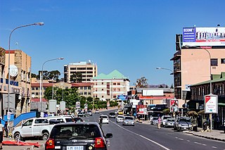
Maseru is the capital and largest city of Lesotho. It is also the capital of the Maseru District. Located on the Caledon River, Maseru lies directly on the Lesotho–South Africa border. Maseru had a population of 330,760 in the 2016 census. The city was established as a police camp and assigned as the capital after the country became a British protectorate in 1869. When the country achieved independence in 1966, Maseru retained its status as capital. The name of the city is a Sesotho word meaning "red sandstones".

<span class="mw-page-title-main">N1 (South Africa)</span> National road in South Africa

The N1 is a national route in South Africa that runs from Cape Town through Bloemfontein, Johannesburg, Pretoria and Polokwane to Beit Bridge on the border with Zimbabwe. It forms the first section of the famed Cape to Cairo Road.

<span class="mw-page-title-main">R24 (South Africa)</span> Road in South Africa

The R24 is a major East-West provincial route in the Gauteng and North West provinces that links OR Tambo International Airport with Rustenburg via Johannesburg, Krugersdorp and Magaliesburg. The process of renaming the streets and freeway that form the route from Krugersdorp eastward to OR Tambo International after anti-apartheid stalwart Albertina Sisulu was completed in 2013.

<span class="mw-page-title-main">R26 (South Africa)</span>

The R26 is a provincial route in Free State, South Africa that connects Rouxville with Villiers via Zastron, Wepener, Ladybrand, Ficksburg, Bethlehem & Reitz.

<span class="mw-page-title-main">R30 (South Africa)</span> Road in South Africa

The R30 is a provincial route in South Africa that connects Bloemfontein with Rustenburg via Brandfort, Welkom, Bothaville, Klerksdorp and Ventersdorp. The southern part of the route is tolled, as the R30 forms the first section of the ZR Mahabane Toll Route, with the Brandfort Toll Plaza found 10 kilometres north of its southern terminus junction with the N1 national route. The tolled portion ends at the junction with the R730.

<span class="mw-page-title-main">R34 (South Africa)</span> Road in South Africa

The R34 is a long provincial route in South Africa that connects Vryburg with Richards Bay via Kroonstad and Newcastle. It passes through three provinces, North West, the Free State and KwaZulu-Natal.

<span class="mw-page-title-main">R59 (South Africa)</span> Road in South Africa

The R59 is a provincial route in South Africa that connects Hertzogville with Alberton via Bothaville, Parys and Vereeniging. The R59 is a freeway from the R57 Junction in Sasolburg until the N12 Reading Interchange in Alberton, signposted as the Sybrand van Niekerk Freeway.

<span class="mw-page-title-main">R63 (South Africa)</span> Road in South Africa

The R63 is a tarred provincial route in South Africa that connects Calvinia with Komga via Carnarvon, Victoria West, Graaff-Reinet, Somerset East and King William's Town. It is cosigned with the N10 between Eastpoort and Cookhouse for 24 kilometres.

<span class="mw-page-title-main">R64 (South Africa)</span>

The R64 is a provincial route in South Africa that connects Kimberley with Bloemfontein via Boshof and Dealesville. It is slightly longer than the newer N8 route via Petrusburg, by about 10 kilometres.

<span class="mw-page-title-main">R76 (South Africa)</span> Road in South Africa

The R76 is a provincial route in Free State, South Africa that connects Orkney with Bethlehem via Kroonstad.

<span class="mw-page-title-main">R82 (South Africa)</span> Road in South Africa

The R82 is a provincial route in South Africa that connects Johannesburg with Kroonstad via Vereeniging and Sasolburg. It starts just south of the M1 Johannesburg Municipal Highway's interchange with the N12 Southern Bypass, going south, meeting the R59, R54, R42 & R28 routes at Vereeniging before crossing the Vaal River into the Free State & proceeding to Kroonstad. It is an alternative, but longer route to the N1 National Route between Johannesburg & Kroonstad.

<span class="mw-page-title-main">N12 (South Africa)</span> National road in South Africa

The N12 is a national route in South Africa which runs from George through Beaufort West, Kimberley, Klerksdorp and Johannesburg to eMalahleni.

<span class="mw-page-title-main">N4 (South Africa)</span> National road in South Africa

The N4 is a national route in South Africa that runs from Skilpadshek on the Botswana border, past Rustenburg, Pretoria, eMalahleni and Mbombela, to Komatipoort on the Mozambique border. The entire route is a toll road.

<span class="mw-page-title-main">N6 (South Africa)</span> National road in South Africa

The N6 is a national route in South Africa that connects East London with Bloemfontein, via Komani and Maletswai. It runs roughly from north to south, connecting the N1 with the N2.

<span class="mw-page-title-main">N10 (South Africa)</span> National road in South Africa

The N10 is a national route in South Africa connecting Gqeberha on the Eastern Cape coast with the Namibian border at Nakop, via Cradock, De Aar and Upington.

<span class="mw-page-title-main">N14 (South Africa)</span> National road in South Africa

The N14 is a national route in South Africa which runs from Springbok in the Northern Cape to Pretoria in Gauteng. It passes through Upington, Kuruman, Vryburg, Krugersdorp and Centurion. The section between Pretoria and Krugersdorp is maintained by the Gauteng Provincial government and is also designated the P158.

The R700 is a regional route in Free State, South Africa that connects Hoopstad with Bloemfontein via Bultfontein and Soutpan.

The R702 is a regional route in South Africa that connects Bloemfontein with the Lesotho border at Van Rooyen's Gate via Dewetsdorp and Wepener.

The R708 is a Regional Route in South Africa that connects Jan Kempdorp in the Northern Cape with Clocolan in the Free State via Christiana, Hertzogville, Bultfontein, Theunissen, Winburg and Marquard.

The Bloemfontein Ring Road, also known as The Bloemfontein bypass is a halfway ring road that circles the city of Bloemfontein, South Africa. It is part of the N1 National Route.

References

  1. Falkner, John (May 2012). South African Numbered Route Description and Destination Analysis (Report). National Department of Transport. p. 22. Archived from the original on 6 June 2014. Retrieved 12 August 2014.
  2. "R64 Road, Griquatown, 8365 - Getpostalcodes.com". www.getpostalcodes.com. Retrieved 10 November 2023.
  3. "Road Condition Report: July 2009" (PDF). South African National Roads Agency. pp. 16–17. Retrieved 22 July 2009.