History
The town started after mail irregularities at Aliwal North led authorities to re-direct mail between the Cape Colony and the Orange Free State to the farm Zuurbult (founded by Petrus Wepenaar) in 1863. The distance between Smithfield and Aliwal North (70 km) was allegedly too long to be travelled in one day by horse and wagon, and as such Rouxville was created as the halfway stopover.
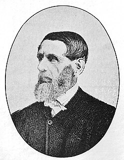
The town was established in 1864 and named after Dutch Reformed Church Reverend Pieter Roux [3] of the Smithfield parish. Roux traveled throughout the Eastern Free State for many years holding church services for local communities.
During the Second Boer War, all of the town's citizens were called up for military service and the town was completely deserted for two years.
A former State President of the Republic of South Africa, Jacobus Johannes (Jim) Fouché (1898-1980), grew up on the family farm in Rouxville, where he first attended school. He later returned to Rouxville after College and became one of the leading farmers of the region. As a leader of the community in the wider Southeast Free State area, he entered politics when he was elected a member of the South African Parliament on the ticket of the Reunited National Party, representing nearby Smithfield (1941-1950), was appointed Administrator of the Orange Free State (1951-1959), served also as Defence Minister (1959-1965) and Minister of Agricultural technical services and water affairs (1966-1968) in the Governments of Verwoerd and Vorster. He was again elected to Parliament, this time representing Bloemfontein West (1960-1968). He was the second choice as successor to Charles Swart as State President, but was defeated by Theophilus Ebenhaezer Donges, however when Donges failed to assume office because of poor health, he emerged as a compromise candidate and was nominated by the Parliamentary caucus of the National Party as State President and served his entire 7-year term (1968-1975).

The Orange Free State was an independent Boer sovereign republic under British suzerainty in Southern Africa during the second half of the 19th century, which ceased to exist after it was defeated and surrendered to the British Empire at the end of the Second Boer War in 1902. It is one of the three historical precursors to the present-day Free State province.
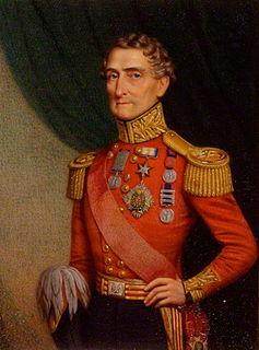
Lieutenant-General Sir Henry George Wakelyn Smith, 1st Baronet, GCB was a notable English soldier and military commander in the British Army of the early 19th century. A veteran of the Napoleonic Wars, he is also particularly remembered for his role in the Battle of Aliwal, India in 1846, his subsequent governorship of the Cape Colony, and as the husband of Lady Smith.

Jozua François "Tom" Naudé served as acting state president of South Africa from 1967 to 1968.

Jacobus Johannes "Jim" Fouché,, also known as J. J. Fouché, was a South African politician who served as the second state president of South Africa from 1968 to 1975.
Paul Roux is a small town in the Free State province of South Africa that produces poplar wood for the safety match industry. It is situated on the N5 highway near Bethlehem, Free State. It was named after a well-known Dutch Reformed Church leader and Second Boer War general, Reverend Paul Hendrik Roux.
Jacobsdal is a small farming town in the Free State province of South Africa with various crops under irrigation, such as grapes, potatoes, lucerne, and groundnuts. The town was layout in 1859 by Christoffel Jacobs on his farm Kalkfontein, and today houses 3,504 inhabitants.

Smithfield is a small town in the Free State province of South Africa. Founded in 1848 in the Orange River Sovereignty, the town is situated in a rural farming district and is the third oldest town in present-day Free State, after Philippolis and Winburg.
Villiers is a small town situated on the banks of the Vaal River next to the N3 highway in the Free State province of South Africa. It was founded in 1882 on the two farms Pearson Valley and Grootdraai owned by Lourens de Villiers.
The following lists events that happened during 1905 in South Africa.
The following lists events that happened during 1885 in South Africa.
Aliwal North is a town in central South Africa on the banks of the Orange River, Eastern Cape Province. It is a medium-sized commercial centre in the northernmost part of the Eastern Cape.

Francis William Reitz, Jr. was a South African lawyer, politician, statesman, publicist, and poet who was a member of parliament of the Cape Colony, Chief Justice and fifth State President of the Orange Free State, State Secretary of the South African Republic at the time of the Second Boer War, and the first president of the Senate of the Union of South Africa.

Sir Johannes Henricus Brand, was a South African lawyer and politician who served as the fourth state president of the Orange Free State, from 2 February 1864 until his death in 1888. He was the son of Sir Christoffel Joseph Brand (1797–1875), speaker of the Cape legislative assembly, and Catharina Fredrica Küchler.
Jacobus Nicolaas Boshof was a South African (Boer) statesman, a late-arriving member of the Voortrekker movement, and the second state president of the Orange Free State, in office from 1855 to 1859.

The N6 is a national route in South Africa that connects East London with Bloemfontein, via Komani and Maletswai. It runs roughly from north to south, connecting the N1 with the N2.
The Diocese of the Free State is a diocese in the Anglican Church of Southern Africa.

Pieter Hendrik Kritzinger, was a Boer general and Assistant Commandant of the Forces of the Orange Free State and Commander-in-Chief of the Boer Rebel Forces in the Cape Colony and noted guerrilla commander during the Second Boer War who led the Boer invasions of the Cape Colony during the Guerilla Phase of the Second Boer War.

Stormberg Commando was a light infantry regiment of the South African Army. It formed part of the South African Army Infantry Formation as well as the South African Territorial Reserve.
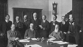
The National Convention, also known as the Convention on the Closer Union of South Africa or the Closer Union Convention, was a constitutional convention held between 1908 and 1909 in Durban, Cape Town and Bloemfontein. The convention led to the adoption of the South Africa Act by the British Parliament and thus to the creation of the Union of South Africa. The four colonies of the area that would become South Africa - the Cape Colony, Natal Colony, the Orange River Colony and the Transvaal Colony - were represented at the convention, along with a delegation from Rhodesia. There were 33 delegates in total, with the Cape being represented by 12, the Transvaal eight, the Orange River five, Natal five, and Rhodesia three. The convention was held behind closed doors, in the fear that a public affair would lead delegates to refuse compromising on contentious areas of disagreement. All the delegates were white men, a third of them were farmers, ten were lawyers, and some were academics. Two-thirds had fought on either side of the Second Boer War.


